This item has been sold, but you can get on the Waitlist to be notified if another example becomes available, or purchase a digital scan.
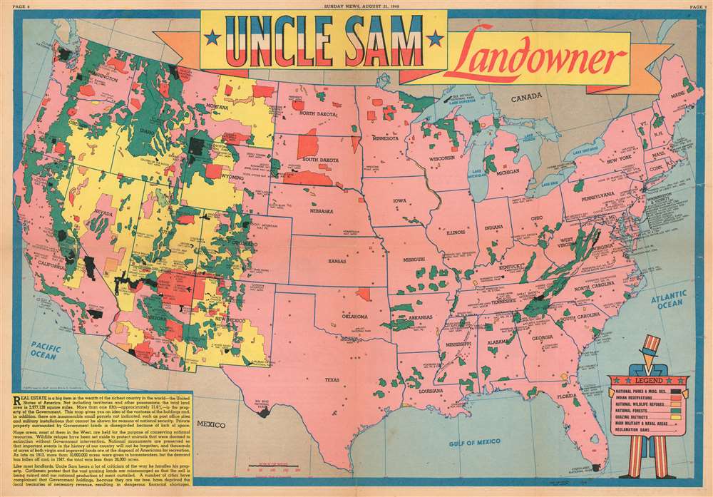
1949 Sundberg Map of United States National Parks, Forests, and Monuments
UncleSamLandowner-sundberg-1949$175.00

Title
Uncle Sam Landowner.
1949 (dated) 14.5 x 21 in (36.83 x 53.34 cm) 1 : 8700000
1949 (dated) 14.5 x 21 in (36.83 x 53.34 cm) 1 : 8700000
Description
This is a 1949 Edwin Sundberg map of the United States marking national parks, forests, monuments, and Indian reservations. The map depicts the continental United States from the Pacific Ocean to the Atlantic Ocean and from Canada to Mexico and the Gulf of Mexico. With the U.S. shaded in pink, the federal lands, highlighted in various different colors, are clearly apparent. National parks, including Yellowstone, Acadia, Grand Canyon, Sequoia, and Yosemite, are shaded black, giving them the most prominent place visually. Red areas are Indian reservations. The green areas are, naturally, national forests, while the orange areas denote national wildlife refuges and the yellow grazing districts. All of the states are labeled, and the national parks are prominently identified by block lettering. Smaller block lettering labels national monuments, while national forests, grazing districts, and Indian reservations remain unidentified by name. The only city referenced, even indirectly, is Washington, D.C. since the District is outlined. The stars that dot the U.S. from coast to coast denote 'military and naval areas'. A legend, held by a caricature of Uncle Sam, is situated in the lower right corner.
Publication History and Census
This map was drawn by Edwin L. Sundberg and published by the Sunday News on August 21, 1949. Even though Sundberg's works were produced for a New York City newspaper, his maps vary in scarcity today. We have been unable to locate any known examples in institutional collections and this map is very rare on the private market.Cartographer
Edwin L. Sundberg (1898 - 1978) was an American cartographer known for his pictorial pieces. Sundberg was a staff artist for the Sunday News in New York City and eventually became Chief Cartographer in charge of a small staff of artists. More by this mapmaker...
Condition
Very good. Newsprint. Closed margin tears professionally repaired on verso, with a handful entering the printed area along the right side. Wear along original fold lines. Text and printed photographs on verso.