1830 Streit Map of the Kingdom of Hungary
UngarischenLandern-streit-1830$950.00

Title
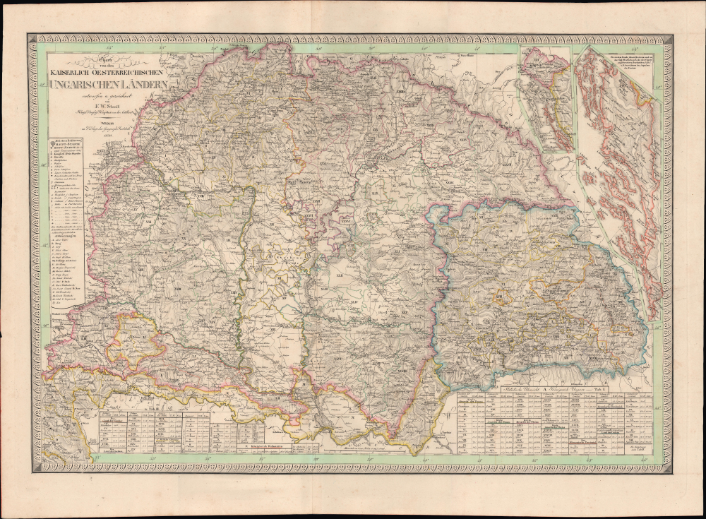
Charte von den Kaiserlich Oesterreichischen Ungarischen Ländern.
1830 (dated) 19.5 x 28.5 in (49.53 x 72.39 cm)
1830 (dated) 19.5 x 28.5 in (49.53 x 72.39 cm)
Description
This is Friedrich Wilhelm Streit's rare 1830 map of the Kingdom of Hungary and associated territories, published by the Geographisches Institut, Weimar. It displays the Lands of the Hungarian Crown, including Transylvania, Slovakia, and much of today's Croatia, in the wake of the Napoleonic Wars (1803 - 1815) as the Habsburgs adjusted to a changed political landscape.
This map was no doubt influenced by Lipszky János' 'Mappa Generalis Regni Hungariae…,' prepared between 1804 and 1806, a groundbreaking work utilizing astronomical positioning (triangulation) that was the basis for maps of the Hungarian realm throughout the early-mid 19th century.
Francis was an arch-conservative who implemented unpopular centralizing policies without consulting the nobility, let alone the common people. When he finally did convene the Diet in 1825 after a very long hiatus, numerous grievances were aired, and calls for reform floated. Count István Széchenyi (1791 - 1860) undertook the daring and even scandalous act of delivering a speech in the Diet in Hungarian instead of Latin, advocating for the establishment of a Hungarian Academy of Sciences. Széchenyi also called for a raft of reforms such as the abolition of serfdom, the creation of a national bank, and major public works, including the first permanent bridge over the Danube linking Buda and Pest (opened in 1849), which still exists and today bears his name. But Széchenyi did not propose separation from Austria and, in fact, believed Hungary's modernization necessitated closer links with Austria. Conversely, a group of lesser nobles led by Lajos Kossuth (1802 - 1894) called for more radical reforms, including parliamentary democracy and de facto independence from Austria. (Kossuth served as Hungary's Governor-President during a brief period of autonomy in 1848 - 1849.)
The calls for reform were impossible to ignore without the danger of provoking even greater unrest, and the monarchy agreed to a degree of diminution of power, with the King convening a Diet every three years. Hungarian was also introduced as an official language alongside Latin, which is likely why it appears here. However, Hungarian had been used in some cartographic works since the late 18th century (by 1850, Hungarian was the kingdom's sole official language). Still, these reforms were not sufficient to dampen widespread discontent, which exploded alongside other revolutions throughout Europe in 1848.
A Closer Look
Coverage extends from the borders of Austria (including Vienna) and Moravia at the top-left nearly to the Adriatic Sea at the bottom-left, and from the Western Carpathian Mountains at the top-right to the borders of Serbia and Wallachia at the bottom-right. A tremendous amount of detail is included, beginning with the complex territorial subdivisions of the lands of the Hungarian monarchy, including directly administered lands (marked with Roman numerals), Croatian lands, Dalmatia, military frontier administrations, and special border zones inhabited by ethnic minorities like the Szeklers (or Székelys). A detailed legend and table of abbreviations at the left indicate the symbols for cities and towns, villages, military garrisons, roads, river crossings, Roman ruins, and other features. Mountains are also indicated with hachures, and waterways are noted throughout, including the Danube (Donau) flowing past Vienna and many of the great cities of the realm, including Buda and Pest. Two insets at the top-right display the lands of the Hungarian crown along the Adriatic coast, which belonged to the Kingdom of Croatia or its semi-autonomous subdivision, the Kingdom of Slavonia. At the bottom are tables of statistics recording the area and population of different administrative regions (comitate).This map was no doubt influenced by Lipszky János' 'Mappa Generalis Regni Hungariae…,' prepared between 1804 and 1806, a groundbreaking work utilizing astronomical positioning (triangulation) that was the basis for maps of the Hungarian realm throughout the early-mid 19th century.
Historical Context
This map was produced in the context of the Hungarian Reform Era (1825 - 1848). These reforms were, in large part, a result of the Age of Revolutions and the Napoleonic Wars, which impacted the Habsburg monarchy and awakened social and national movements that would define the following decades. The changes instituted were meant to mollify both Hungarian nationalist sentiment and discontent from the serfs and other unfree people who composed the vast majority of the population. The Absolutist monarch Francis II (r. 1792 - 1835) had led Hungary and the wider Habsburg lands through the trials of the Napoleonic Wars, which saw the end of the Holy Roman Empire and the creation of the Empire of Austria, whose emperor (kaiser) was also the King of Hungary (who also ruled Slovakia and much of today's Croatia).Francis was an arch-conservative who implemented unpopular centralizing policies without consulting the nobility, let alone the common people. When he finally did convene the Diet in 1825 after a very long hiatus, numerous grievances were aired, and calls for reform floated. Count István Széchenyi (1791 - 1860) undertook the daring and even scandalous act of delivering a speech in the Diet in Hungarian instead of Latin, advocating for the establishment of a Hungarian Academy of Sciences. Széchenyi also called for a raft of reforms such as the abolition of serfdom, the creation of a national bank, and major public works, including the first permanent bridge over the Danube linking Buda and Pest (opened in 1849), which still exists and today bears his name. But Széchenyi did not propose separation from Austria and, in fact, believed Hungary's modernization necessitated closer links with Austria. Conversely, a group of lesser nobles led by Lajos Kossuth (1802 - 1894) called for more radical reforms, including parliamentary democracy and de facto independence from Austria. (Kossuth served as Hungary's Governor-President during a brief period of autonomy in 1848 - 1849.)
The calls for reform were impossible to ignore without the danger of provoking even greater unrest, and the monarchy agreed to a degree of diminution of power, with the King convening a Diet every three years. Hungarian was also introduced as an official language alongside Latin, which is likely why it appears here. However, Hungarian had been used in some cartographic works since the late 18th century (by 1850, Hungarian was the kingdom's sole official language). Still, these reforms were not sufficient to dampen widespread discontent, which exploded alongside other revolutions throughout Europe in 1848.
Publication History and Census
This map was prepared by Friedrich Wilhelm Streit and published in 1830 by the Geographisches Institut in Weimar. It is the second edition of the map, following an 1825 edition. Both editions are quite scarce, with the present one only being noted among the holdings of three institutions in the OCLC: the Deutsches Museum Library in Munich, Utrecht University, and the Thüringer Universitäts- und Landesbibliothek. Examples are also held by the National Archives of Hungary and the Univerzita Karlova. No known market history.CartographerS
Friedrich Wilhelm Streit (January 29, 1772 - June 12, 1839) was a Prussian military officer, engineer, mathematician, and cartographer. Streit began his career as an artillery officer in the Prussian military, where he honed his mathematical and cartographic skills. After leaving military service at the rank of major, he became a member of the Akademie gemeinnütziger Wissenschaften zu Erfurt and Gesellschaft für Erdkunde, one of the leading Prussian geographical bodies of the day. From 1807 to 1817 he was director of the map department of the Geographisches Institut Weimar. Over the same period, he oversaw the 'Topographisch-militairische Charte von Teutschland,' an ambitious project to survey the entirety of Central Europe on a consistent medium scale (1:180000), resulting in over 200 maps and supplements. He also published textbooks on mathematics and an English-German dictionary. More by this mapmaker...
Geographisches Institut, Weimar (fl. 1804 - c. 1903) was a German map and globe publishing house and geographical research institute based in Weimar. The organization primarily focused on republishing and improving upon the works of earlier cartographers, including Kitchin, Jefferys, Carey, and others. In general, its publications are known for their fine engraving, attention to detail, historical accuracy, and overall high quality. The firm was founded in 1804 by Friedrich Justin Bertuch (???? - c. 1845) and, on his death, passed to his son Robert Froreip (???? - 1855), then to Louis Denicks of Luneberg, then in 1859 to Voigt & Günther, in 1883 to F. Arnd, from 1890 - 1893 to Julius Kettler, and in 1903 to Max Wedekind. During the institute's height in the early 19th century, most of its cartographic publication was overseen by Carl Ferdinand Weiland (1782 - 1847). The firm also employed the cartographers Franz Xaver von Zach, Adam Christian Gaspari, Heinrich Kiepert, Karl (or Carl) and Adolf Graef, Julius Kettler, Carl Riemer and Karl Christian Bruhns. Weimar was a logical place for a collective like the Geographisches Institut to arise; it was a cultural mecca in the German-speaking world in the late 18th and 19th centuries because of its liberal atmosphere and associations with figures like Schiller, Herder, and, above all, Goethe, who spent most of his adult life in the city. Learn More...
Condition
Very good. Light wear along original centerfold.
References
OCLC 247397429, 902603562. Magyar Nemzeti Levéltár S 68 Festetics család (1645-1943) • S Családi fondokból kiemelt térképek (17. sz.-20. sz.) • S – Térképtár. Univerzita Karlova Přírodovědecká fakulta (Mapová sbírka).