This item has been sold, but you can get on the Waitlist to be notified if another example becomes available, or purchase a digital scan.
1855 Stein and Heck Map of the United States (w/German Colony of Wartburg)
UnitedState-stein-1855$325.00

Title
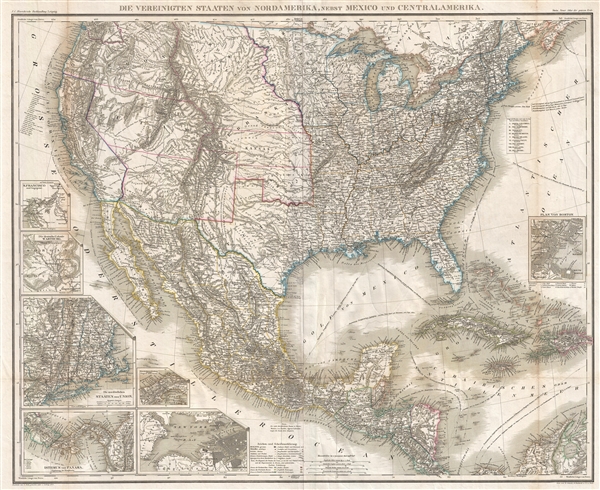
Die Vereinigten Staaten von Nordamerika, nebst Mexico und Centralamerika.
1855 (dated) 26 x 32 in (66.04 x 81.28 cm) 1 : 7250000
1855 (dated) 26 x 32 in (66.04 x 81.28 cm) 1 : 7250000
Description
A very rare 1855 large format map of the United States, Mexico, and the West Indies. The map covers from the Great lakes to Costa Rica and from the Atlantic to the Pacific. There are seven insets detailing important regions, including San Francisco, New England, Panama, New York city and harbor, and Boston. The last inset, the Germany colony of Wartburg, in Morgan County, Tennessee. In the German fashion, this map is incredibly detailed throughout with small print and exceptional elegant engraving.
Wartburg, the German colony appearing in one of this map's insets, was founded in the 1840s by George Gerding, a land speculator who bought up large tracts of land in Morgan County, Tennessee, with plans to establish a series of German colonies in the Cumberland region. German and Swiss immigrants arrived at the site by traveling from New Orleans up the Mississippi, Tennessee, and Emory rivers. They named the settlement after Wartburg Castle in Germany. Wartburg was officially incorporated in 1851. Today it is the county seat. The cartographer also names German colonies in Texas.
The map further illustrates a very ephemeral and, at the time, up to date configuration of the the Transmississippi. Nebraska extends northwards to the Canada border. Utah and New Mexico both extend from California to the Rocky Mountains, incorporating much of modern day Nevada, Colorado, Wyoming, and Arizona. Oregon similarly extends eastward to the Rocky Mountains. The map politically cuts off the Pacific Northwest, the border of which was then a point of contention between the United States and Great Britain.
We have not been able to identify another separate example of this map in any collection public or private. According to text in the upper right corner, it was published for the 1855 edition of Christ Gottfr Dan Stein's Neuer Atlas der ganzen Erde fur die Gebildeten Stande und fur schulen but is disproportionally large for that atlas and therefore may have been a separately issue supplement added to capitalize on local interest in German colonies in the United States.
Source
Stein, Christ Gottfr Dan, Neuer Atlas der ganzen Erde fur die Gebildeten Stande und fur schulen, (Berlin) 1855.
Condition
Very good. Some wear and verso reinforcement on original fold lines.
References
Phillips (Atlases) p. 196-97, #4337.