
This item below is out of stock, but another example (left) is available. To view the available item, click "Details."
Details
1853 Colton Case Map of the United States
$5,000.00
1853 Colton Case Map of the United States
UnitedStates-colton-1853$3,000.00

Title
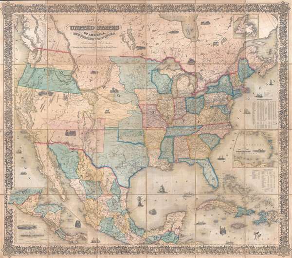
Colton's map of the United States of America, the British provinces, Mexico and the West Indies. Showing the country from the Atlantic to the Pacific Ocean.
1854 (dated) 53 x 60 in (134.62 x 152.4 cm) 1 : 4800000
1854 (dated) 53 x 60 in (134.62 x 152.4 cm) 1 : 4800000
Description
This is a large 1853/54 J. H. Colton dissected wall map of the United States with significant Trans-Mississippi and Great Plains content. This is the largest and most significant of the three separate issue maps of the United States Colton issued in the 1850s. It covers the entire United States as well as most of Mexico, parts of southern Canada, and the Greater Antilles. Central America and the lower Antilles appear in insets. There are numerous ethnographical, geographical, and historical vignettes throughout including a wagon train, American Indians hunting, ships, palm trees, volcanoes, and more.
Fascinating Trans-Mississippi
While the map is expansive in its coverage, the main focus of interest is the Trans-Mississippi, a region then undergoing active exploration, aggressive settlement, and near monthly political boundary changes. The early appearance of Nebraska Territory, unusual territorial borders for Indian Territory and Nebraska Territory, and a late curious appearance of Northwest Territory are of particular note.
Ephemeral Treatment of Great Plains
The highlight of this map is its highly ephemeral treatment of the Great Plains. The map predates the May 1854 Kansas-Nebraska Act by a matter of months. Consequently, Nebraska appears as a large unincorporated territory bounded on the by the strangely shaped Indian Territory and on the west by Utah and New Mexico Territories. To the east, the Indian Territory stretches from Texas to modern day Nebraska-Dakota border and its odd shape roughly follows Indian Treaties dating to the 1820s and 1930s and is probably derived from the 1834 Hood map of the Western Territory. North of Nebraska, a large expanse of land extending to the Canadian border, incorporating modern day North and South Dakota, Wyoming, and Montana, is curiously identified as the 'Northwest Territory.' While the term 'Northwest Territory' typically applies to the 1787 Northwest Ordinance lands around Michigan, Wisconsin, and Minnesota, the use of it here is singular and unexplained. Within a few months these lands would be incorporated into the new Nebraska Territory and divorced from the new Kansas Territory to the south. The 1854 Kansas-Nebraska Act would likewise reconfigure the Indian Territory to appear much as Oklahoma does today.
Gadsden Purchase: Competing Bartlett and Graham Lines.
James Gadsden's Purchase treaty was signed on December 30 of 1853 and the absence of the official new border suggests that Colton, generally a very conscientious mapmaker, was unaware of the changes when this map was issued - meaning it was probably printed late in 1853. Colton does include the competing 1850 survey work of Yankee John Russell Bartlett, whose line extends westward from the Rio Grande about 40 miles north of El Paso, and the competing line of the southerner astronomer James Graham well to the south. Bartlett, not a proper scientist, had fired his surveyor, Robert McClellan, and so followed the guidance of his Mexican compatriots, consequently mapping the line too far north according to the Treaty of Guadeloupe-Hidalgo. Graham, Bartlett's new head surveyor, recognized the error and saw it as an attempt to keep the southern states from building an easy and practical railroad to the Pacific. Graham consequently advocated for his own line further south. Bartlett's line, as the leader of the survey, was ultimately used, but when the time came to build the Southern Pacific Railroad, the matter had to be rectified in the form of the Gadsden Purchase.
Utah Territory: Fillmore and Emigrant Trails
Utah appears as a singular large territory incorporating modern-day Nevada and parts of modern Wyoming and Colorado. Both Fillmore City and Great Salt Lake are identified as capitals with precedence being giving to the Mormon settlement. The layout of Great Salt Lake itself is surprisingly vague given that Colton clearly had access to the 1852 Stansbury Report, naming one of the islands Stansbury named after himself. The map further notes Fremont's 1845 route, Tuckeyo Road [Truckee], and Lawson's Cut Off.
Colton first issued this map in 1853, as stated in the copyright, and Wheat notes an 1853 edition, but we not been able to positively identify any example with 1853 in the title - although we presume that such exists (or existed). The date in the title here is 1854, but the content of the map is more accurate to the geography of 1853 than to what appears on definite 1854 states of the map. This, compounded with the absence of the official lines of the Gadsden Purchase, ratified in December of 1853, suggest an issue date of late 1853, despite the 1854 date.
There are at least four major states of this map with several variants likely:
- 1853 - as here. Pre- Gadsden Purchase. Pre Kansas-Nebraska Act. 'Northwestern Territory' identified in Wyoming, Dakota, an Montana. Possible variant with 1853 date in title.
- 1855 - We have not been able to examine this variant, but there is one in the Huntington Library.
- 1856 - Gadsden Purchase recognized and included.
Cartographer
Joseph Hutchins Colton (July 5, 1800 - July 29, 1893), often publishing as J. H. Colton, was an important American map and atlas publisher active from 1833 to 1897. Colton's firm arose from humble beginnings when he moved to New York in 1831 and befriended the established engraver, Samuel Stiles. He worked under Stiles as the 'Co.' in Stiles and Co. from 1833 to 1836. Colton quickly recognized an emerging market in railroad maps and immigrant guides. Not a cartographer or engraver himself, Colton's initial business practice mostly involved purchasing the copyrights of other cartographers, most notably David H. Burr, and reissuing them with updated engraving and border work. His first maps, produced in 1833, were based on earlier Burr maps and depicted New York State and New York City. Between 1833 and 1855, Colton proceeded to publish a large corpus of guidebooks and railroad maps, which proved popular. In the early 1850s, Colton brought his two sons, George Woolworth Colton (1827 - 1901) and Charles B. Colton (1832 - 1916), into the map business. G. W. Colton, trained as a cartographer and engraver, was particularly inspired by the idea of creating a large and detailed world atlas to compete with established European firms for the U.S. market. In 1855, G.W. Colton issued volume one of the impressive two-volume Colton's Atlas of the World. Volume two followed a year later. Possibly because of the expense of purchasing a two-volume atlas set, the sales of the Atlas of the World did not meet Colton's expectations, and so, in 1856, the firm also issued the atlas as a single volume. The maps contained in this superb work were all original engravings, and most bear an 1855 copyright. All of the maps were surrounded by an attractive spiral motif border that would become a hallmark of Colton's atlas maps well into the 1880s. In 1857, the slightly smaller Colton's General Atlas replaced the Atlas of the World. Most early editions of the General Atlas published from 1857 to 1859 do not have the trademark Colton spiral border, which was removed to allow the maps to fit into a smaller format volume. Their customers must have missed the border because it was reinstated in 1860 and remained in all subsequent publications of the atlas. There were also darker times ahead; in 1858, Colton was commissioned at a sum of 25,000 USD by the government of Bolivia to produce and deliver 10,000 copies of a large format map of that country. Although Colton completed the contract in good faith, delivering the maps at his own expense, he was never paid by Bolivia, which was at the time in the midst of a series of national revolutions. Colton would spend the remainder of his days fighting with the Bolivian and Peruvian governments over this payment, and in the end, after a congressional intervention, he received as much as 100,000 USD in compensation. Nonetheless, at the time, it was a disastrous blow. J. H. Colton and Company is listed as one of New York's failed companies in the postal record of 1859. This led Colton into the arms of Alvin Jewett Johnson and Ross C. Browning. The 1859 edition of Colton's General Atlas lists Johnson and Browning as the 'Successor's to J. H. Colton' suggesting an outright buyout, but given that both companies continued to publish separately, the reality is likely more complex. Whatever the case may have been, this arrangement gave Johnson and Browning access to many of Colton's map plates and gave birth to Johnson's New Illustrated (Steel Plate) Family Atlas. The Johnson's Atlas was published parallel to Colton's atlases well into the 1880s. The Colton firm itself subsequently published several other atlases including an Atlas of America, the Illustrated Cabinet Atlas, the Octavo Atlas of the Union, and Colton's Quarto Atlas of the World. They also published a large corpus of wall maps, pocket maps, and guides. The last known publications of the Colton firm date to 1897 and include a map and a view, both issued in association with the Merchant's Association of New York. Alice M. Colton married August R. Ohman (May 3, 1859 - April 22, 1934) on January 5, 1897. In 1898, Ohman joined the Colton firm, which continued to publish as Colton, Ohman & Co. until 1901. More by this mapmaker...
Condition
Good. Even overall toning. Dissected and mounted on linen, which has been reinforced on verso in several places. Some edge wear. Else good with original linen backing.
References
Wheat, C. I., Mapping of the Transmississippi West, 1540 – 1861, #776. Martin, James C., and Martin, Robert S., Map of Texas and the Southwest, 1513 - 1900, pages 148 - 149. OCLC 40899227.