This item has been sold, but you can get on the Waitlist to be notified if another example becomes available, or purchase a digital scan.
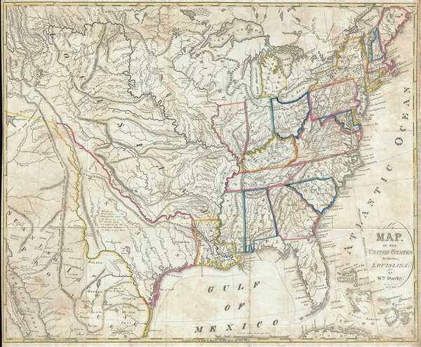
1818 William Darby Map of the United States (w/Texas)
UnitedStates-darby-1818$1,900.00

Title
A Map of the United States Including Louisiana.
1818 (undated) 18.5 x 22.75 in (46.99 x 57.785 cm) 1 : 6336000
1818 (undated) 18.5 x 22.75 in (46.99 x 57.785 cm) 1 : 6336000
Description
A fascinating 1818 map of the United States by William Darby. Intended for use by emigrants migrating westward in the early 19th century, this map covers from the Great Salt Lake (Lake Timpanagos) to the Atlantic seaboard and from Lake of the Woods to Cuba and Baha California in the vicinity of Cabo San Lucas and Mazatlan. With the exception of Louisiana, which became a state in 1812, the settled part of the United States is here limited to those lands east of the Mississippi River, an area comprising only about 1/3rd of the map. The remainder of the map to the west of the Mississippi is dedicated to Texas, Louisiana Territory, and Spanish Mexico.
Darby's rendering of Texas is interesting and significant. At this time, the ownership of Texas was under debate and there is some ambiguity here regarding that region's governance, as it is rendered distinct from both Mexico and the United States. In the United States, it was widely believed that Texas was in fact part of French Louisiana acquired by Jefferson via the Louisiana Purchase, referencing the landing of La Salle at the Mouth of the Guadalupe River in 1683. Although Darby does not consider Texas to be particularly desirable for agricultural or settlement purposes,
The lands to the north of Texas are more properly the Louisiana Territory. Darby focuses on river systems and the occasional American Indian settlements, identifying villages associated with the Osage, Kansas, Fox, Pawnee, Sioux, and others. Pike's Peak is not identified. On the other hand, Yellowstone National Park's Lake Biddle and Lake Ennis, modern day Jackson Lake and Yellowstone Lake, respectively, are both identified.
The map was drawn by William Darby. It was engraved by James D. Stout and printed by Harrison and Bushworth in Brooklyn, NY> This map was published by Kirk and Mercien to accompany Darby's 1818 Emigrant's Guide to the Western and Southwestern States and Territories.
Darby's rendering of Texas is interesting and significant. At this time, the ownership of Texas was under debate and there is some ambiguity here regarding that region's governance, as it is rendered distinct from both Mexico and the United States. In the United States, it was widely believed that Texas was in fact part of French Louisiana acquired by Jefferson via the Louisiana Purchase, referencing the landing of La Salle at the Mouth of the Guadalupe River in 1683. Although Darby does not consider Texas to be particularly desirable for agricultural or settlement purposes,
Texas cannot become an immediate object of attention to emigrants; its territory is not yet politically under the authority of the United States, and countries superior in soil, and agricultural and commercial facilities, are open to settlement.He strongly defends an American claim on that region which he believed, as it does today, should properly extend westward as far as the Rio Grande. It is of note that Darby identifies the French settlement of Nacogdoches, but not the Spanish capital of Los Adaes just 9 miles to the west. His interest in incorporating Texas as an American territory is primarily to capitalize on the many important Gulf of Mexico Ports available along the Texas Coast.
The lands to the north of Texas are more properly the Louisiana Territory. Darby focuses on river systems and the occasional American Indian settlements, identifying villages associated with the Osage, Kansas, Fox, Pawnee, Sioux, and others. Pike's Peak is not identified. On the other hand, Yellowstone National Park's Lake Biddle and Lake Ennis, modern day Jackson Lake and Yellowstone Lake, respectively, are both identified.
The map was drawn by William Darby. It was engraved by James D. Stout and printed by Harrison and Bushworth in Brooklyn, NY> This map was published by Kirk and Mercien to accompany Darby's 1818 Emigrant's Guide to the Western and Southwestern States and Territories.
Cartographer
William Darby (August, 14 1775 – 1854) was a prominent American surveyor and mapmaker active in the United States during the first half of the 19th century. Of Irish descent, Darby was born in Pennsylvania one year before the outbreak of the Revolutionary War. His family relocated to Ohio where Darby grew up. In 1799 he moved to Natchez to establish himself as a cotton planter. It must have been around his time what he taught himself surveying, as his earliest survey work to about 1804 and includes commercial surveys in Attakapas County, Louisiana. A fire in that year destroyed much of his plantation and forced him into financial ruin. He subsequently took a commission as Deputy Surveyor for the United States General Land Office. During the War of 1812 he served under Andrew Jackson as a cartographer. Darby is best known for his important map of Louisiana, published by John Melish in 1816, the first and most influential map of the state to date. For this he is considered the 'Father of Louisiana geography.' He also worked to survey the American-Canada border after the War of 1812. Among his more important surveys are the first accurate maps of Lake Ponchartrain and the Sabine River. In all he claims to have covered some 20,000 miles doing survey work. Around 1838 he took a position as professor of history, geography, and astronomy at Jefferson College in Cannonsburg Pennsylvania. Two years later he moved to Washington D.C. From 1842 to 1854, when he died, Darby worked as a clerk in the General Land Office. More by this mapmaker...
Source
Darby, W., The Emigrant's Guide to The Western and Southwestern States and Territories… (New York: Kirk and Mercein) 1818. Printed by Harrison and Bushworth of Brooklyn, New York.
Condition
Good. Some acid transference and edge wear. Right margin extended from neat line. Original fold lines exhibit minor wear. A couple of minor verso reinforcements.
References
New York Public Library, b15110729. Phillips (America) P. 879. OCLC 945087999. Wheat, C. I., Mapping of the Transmississippi West, 1540 – 1861, #326. Howes, W., U.S.iana (1650-1950): A Selective Bibliography in which are Described 11,620 Uncommon and Significant Books Relating to the Continental Portion of the United States, D61.