Digital Image: 1818 William Darby Map of the United States (w/Texas)
UnitedStates-darby-1818_d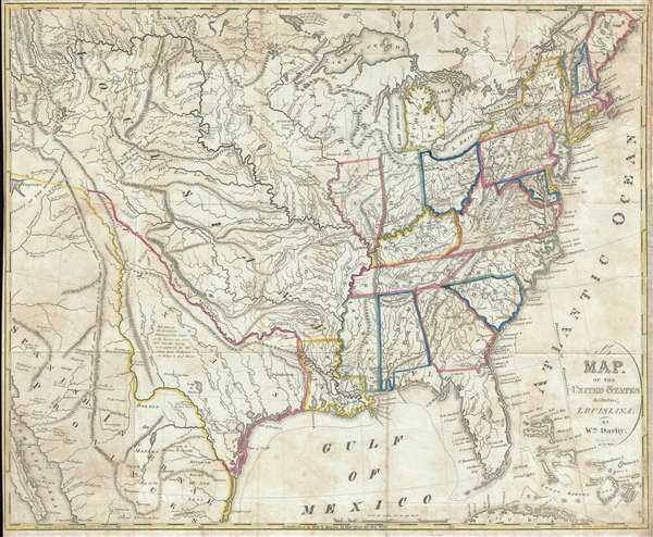

Title
A Map of the United States Including Louisiana.
1818 (undated) 18.5 x 22.75 in (46.99 x 57.785 cm) 1 : 6336000
1818 (undated) 18.5 x 22.75 in (46.99 x 57.785 cm) 1 : 6336000
Description
FOR THE ORIGINAL ANTIQUE MAP, WITH HISTORICAL ANALYSIS, CLICK HERE.
Digital Map Information
Geographicus maintains an archive of high-resolution rare map scans. We scan our maps at 300 DPI or higher, with newer images being 600 DPI, (either TIFF or JPEG, depending on when the scan was done) which is most cases in suitable for enlargement and printing.
Delivery
Once you purchase our digital scan service, you will receive a download link via email - usually within seconds. Digital orders are delivered as ZIP files, an industry standard file compression protocol that any computer should be able to unpack. Some of our files are very large, and can take some time to download. Most files are saved into your computer's 'Downloads' folder. All delivery is electronic. No physical product is shipped.
Credit and Scope of Use
You can use your digial image any way you want! Our digital images are unrestricted by copyright and can be used, modified, and published freely. The textual description that accompanies the original antique map is not included in the sale of digital images and remains protected by copyright. That said, we put significant care and effort into scanning and editing these maps, and we’d appreciate a credit when possible. Should you wish to credit us, please use the following credit line:
Courtesy of Geographicus Rare Antique Maps (https://www.geographicus.com).
How Large Can I Print?
In general, at 300 DPI, you should at least be able to double the size of the actual image, more so with our 600 DPI images. So, if the original was 10 x 12 inches, you can print at 20 x 24 inches, without quality loss. If your display requirements can accommodate some loss in image quality, you can make it even larger. That being said, no quality of scan will allow you to blow up at 10 x 12 inch map to wall size without significant quality loss. For more information, it is best consult a printer or reprographics specialist.
Refunds
If the high resolution image you ordered is unavailable, we will fully refund your purchase. Otherwise, digital images scans are a service, not a tangible product, and cannot be returned or refunded once the download link is used.
Cartographer
William Darby (August, 14 1775 – 1854) was a prominent American surveyor and mapmaker active in the United States during the first half of the 19th century. Of Irish descent, Darby was born in Pennsylvania one year before the outbreak of the Revolutionary War. His family relocated to Ohio where Darby grew up. In 1799 he moved to Natchez to establish himself as a cotton planter. It must have been around his time what he taught himself surveying, as his earliest survey work to about 1804 and includes commercial surveys in Attakapas County, Louisiana. A fire in that year destroyed much of his plantation and forced him into financial ruin. He subsequently took a commission as Deputy Surveyor for the United States General Land Office. During the War of 1812 he served under Andrew Jackson as a cartographer. Darby is best known for his important map of Louisiana, published by John Melish in 1816, the first and most influential map of the state to date. For this he is considered the 'Father of Louisiana geography.' He also worked to survey the American-Canada border after the War of 1812. Among his more important surveys are the first accurate maps of Lake Ponchartrain and the Sabine River. In all he claims to have covered some 20,000 miles doing survey work. Around 1838 he took a position as professor of history, geography, and astronomy at Jefferson College in Cannonsburg Pennsylvania. Two years later he moved to Washington D.C. From 1842 to 1854, when he died, Darby worked as a clerk in the General Land Office. More by this mapmaker...
Source
Darby, W., The Emigrant's Guide to The Western and Southwestern States and Territories… (New York: Kirk and Mercein) 1818. Printed by Harrison and Bushworth of Brooklyn, New York.