This item has been sold, but you can get on the Waitlist to be notified if another example becomes available, or purchase a digital scan.
1834 Lucy Durfee Manuscript Schoolgirl Map of the United States - Americana
UnitedStates-durfee-1834$900.00

Title
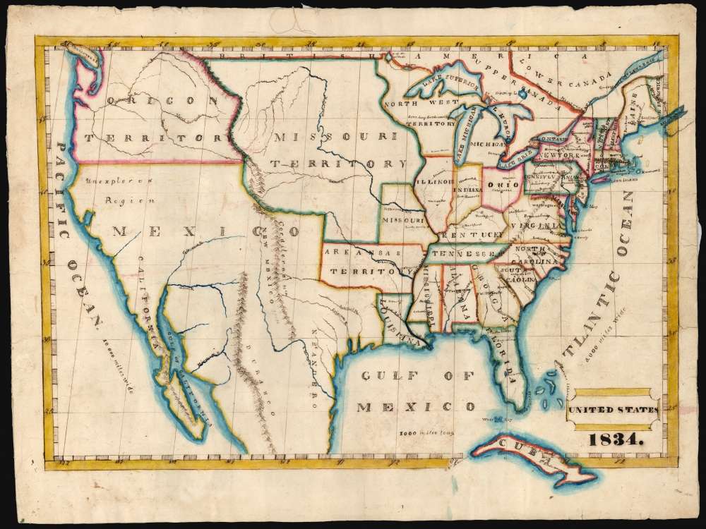
United States 1834.
1834 (dated) 15 x 20.75 in (38.1 x 52.705 cm) 1 : 10100000
1834 (dated) 15 x 20.75 in (38.1 x 52.705 cm) 1 : 10100000
Description
This is a beautifully executed schoolgirl map of the United States, drawn in 1834 by Lucy Durfee (conjecturally the daughter of legislator and congressman Job Durfee).
The goals of these exercises were more far-reaching than teaching geography. Girls learned penmanship, each map often using three or more lettering styles. Mapmaking sharpened the retention and recall of factual information. Students were encouraged to take pains in their draftsmanship, and often achieved beautiful flourishes of artistic expression. But most peculiar to the American iterations of educational mapping was the goal of instilling a sense of civic pride and responsibility. Indeed, the key desired result of the education of girls in the post-Revolutionary-War United States was to prepare for the education of the next generation of American citizens, a patriotic duty which would primarily fall on the shoulders of these young women.
A Closer Look
It shows what would become the continental United States, illustrating not only the nation east of the Mississippi but also its territories to the west and northwest, and the expanse of Mexican territory to the Southwest. States are shown along with their capitals and some principal cities. As with most schoolgirl maps, this is executed on paper with pen, ink, and watercolors. Mountains and coastlines are indicated pictorially, with an elegance modeling the engraved maps of the period. Rivers are carefully drafted and named as well. The rivers of the northwest show familiarity with the maps deriving from the Lewis and Clark expedition, most probably an edition of Melish's map. The map is neatly lettered. The lettering for large regions is particularly decorative. The present example was treasured from an early date, as indicated by having been mounted on linen for preservation.The Source
Schoolgirl maps, necessarily, were drawn based on the maps of their respective regions found in popular atlases of their day; scrutiny of the content of the map can reveal clues identifying the source. The most up-to-date information appearing on the map pertains to America west of the Mississippi. Arkansas Territory and Missouri are delineated. The State of Missouri is shown along with its capital at Jefferson City; thus Durfee's source cannot have been earlier than 1821. The map contains many details that make an 1822 Melish a good candidate, but the capital name for the Arkansas Territory - Arkopolis - points elsewhere. (Melish names it 'Post.' Today's Little Rock.) In Wisconsin, Durfee notes the Green Bay Settlement, which was begun in 1821 but would not be fully established until the next decade. Overall, the 1826 Finley New American Atlas seems the best fit, both in terms of the source material and in terms of the availability. There are elements - most notably the naming of the Oregon Territory - which did not originate with the Finley and would have had to come from another source. This may have been a map, such as the Tanner, but the household of a scholar and legislator would have had access to other, more current sources, and Lucy may have been able to apply more current knowledge to her map than a decade-old atlas would have been able to provide.Identifying the Author
Although the present work is not signed, we have acquired it along with three other such maps (New England, Rhode Island, and Europe) which are similarly dated, and of which two are signed by the young Miss Durfee. The painstaking work, the style of lettering, and the coloring show all four to be by the same hand, so we are confident in thus naming the author of this United States map. We see evidence of a girl of that name born in Tiverton, Rhode Island, in about 1821 who fits contextually, but since such 'schoolgirl maps' were student works of young women virtually all destined for marriage and motherhood, it is nearly impossible to be completely certain of the identity of its young author. We do find a Lucy Durfee, born in 1821 and living to 1890, who represents a compelling possibility. She was the eldest daughter of a Rhode Island lawyer, lawmaker and congressman with a literary bent. His household would certainly have had the resources clearly available to the author of this map, and such an individual can be expected to have educated his daughter as a Federalist citizen and mother of the next generation of engaged and patriotic Americans.Schoolgirl Maps
While the use of mapmaking in teaching is first seen in Europe, mainly England, the Schoolgirl Map became a peculiarly American pedagogical tool in the first part of the 19th century, a period in which standards and purposes in women's education were changing. While boys were frequently taught the practical execution of surveys and charts, the production of attractive and informative maps appears to have been primarily the domain of young women. Such maps can be found of the World, the United States, or more specific maps of states. These were usually based on generally available reference maps, such as those found in the atlases produced by Carey and Lea, Finley, and Mitchell.The goals of these exercises were more far-reaching than teaching geography. Girls learned penmanship, each map often using three or more lettering styles. Mapmaking sharpened the retention and recall of factual information. Students were encouraged to take pains in their draftsmanship, and often achieved beautiful flourishes of artistic expression. But most peculiar to the American iterations of educational mapping was the goal of instilling a sense of civic pride and responsibility. Indeed, the key desired result of the education of girls in the post-Revolutionary-War United States was to prepare for the education of the next generation of American citizens, a patriotic duty which would primarily fall on the shoulders of these young women.
Publication History and Other Examples
For a good overview, see Betty Mason's '19th Century Schoolgirls Were Incredibly Good at Drawing Maps.' Published July 27, 2016 by National Geographic.Cartographer
Lucy Durfee (Borden) (January 18, 1821 - July 26, 1890) was a Rhode Islander; she was born, lived, and died in Tiverton near Newport. Her father, The Hon. Job Durfee, LL.D. (1790 - 1847), was a lawyer, state legislator, a federalist congressman, a poet, and author. Lucy, the eldest of seven siblings - at least one of whom was an author as well - would have been brought up in a literate and studious household. While she appears to have published nothing, in her youth she would have been educated in the early American vein, intended to make her better able to raise a generation of literate, politically intelligent young Americans. As evidence of this, there are no fewer than four 'schoolgirl' maps in her hand that have survived. In 1846 she married Thomas Hicks Borden, with whom she raised at least eight children, to whom it is to be hoped that she passed along her studiousness and curiosity. More by this mapmaker...
Condition
Very good. Manuscript pen, ink and watercolor on paper; mounted for preservation on old linen.