
1867 General Land Office Map of the United States

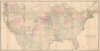

Map of the United States and Territories, Showing the extent of Public Surveys and other details, Constructed from the Plats and official sources of the General Land Office.
Irrational Railroad Exuberance.
- Digital Map Information
- Suitable for large format printing
- Full resolution TIFF file
- ICC color profile embedded
- Delivered instantly via download link
Irrational Railroad Exuberance.
This is an 1870 map of the United States issued by the U.S. General Land Office, led by Commissioner Joseph S. Wilson. Rich in detail, it illustrates the progress of U.S. government land surveys from coast to coast, also reflecting information on mineral deposits, the development of railways, and settlement patterns on the vast American frontier.A Closer Look
The map depicts the contemporary United States from the Pacific to the Atlantic and from Canada to Mexico, including a sizable portion of the latter. It offers impressive detail, with township grids established throughout the earliest territories/states added after the original Thirteen Colonies (such as the former Northwest Territory, Southern states, and early 'Western' states like Missouri and Iowa). Coverage is more sporadic on the contemporary frontier, although most of Kansas, Minnesota, and California are surveyed, along with portions of the remaining territories. As the map notes, large private claims of irregular shape (meaning they did not fit into the neat, orderly grid established by the Public Land Survey System following the adoption of the Northwest Ordinance) existed in Arkansas, Florida, Louisiana, and Missouri. This map is notable because, created after the formation of the Wyoming Territory in 1868, it was among the earliest G.L.O. maps to reflect a territorial configuration of the contiguous United States that essentially aligns with its ultimate arrangement.American Indian reservations and Indian Agent offices are identified throughout the West. A key in the lower left notes that the large green dots throughout represent a surveyor general's office, while the smaller red dots indicate a land office, both of which played critical roles in these surveys. The other smaller colored dots indicate mineral deposits. The minerals traced here include gold, silver, copper, quicksilver (mercury), iron, tin, asphalt, coal, and oil. Additionally, waterways, mountains, settlements, forts, and other features are labeled throughout, while notes are provided on terrain, water sources, and other important details. Remnants of historical (anachronistic) territories, such as the Territory of Bexar and the Territory of Young, in western Texas are also retained.
Transcontinental Railroads
This map was issued in the immediate aftermath of the completion of the first transcontinental railroad in May 1869, which linked the Union Pacific and Central Pacific lines at Promontory Summit, Utah. Although the economic logic for one such railroad was questionable and the argument for multiple Transcontinental railroads was spurious, the U.S. government (for political reasons) and corporate syndicates (for reasons of financial self-interest) aggressively pursued additional corridors along different parallels. Ground was broken in 1870 on the Northern Pacific Railway to connect Lake Superior to the Pacific Northwest, while the Atchison, Topeka and Santa Fe Railway (ATSF) began pushing west through Kansas. Farther south, the Southern Pacific was rapidly laying track across California toward the Colorado River, anticipating a junction with eastern lines along the 32nd parallel.Beyond these active projects, the era was filled with speculative, struggling, and ultimately failed projected lines. Indeed, some of the lines traced here are noted as having not even been surveyed, indicating their highly tentative nature. The Atlantic and Pacific Railroad (seen here running southwest from St. Louis to Indian Territory), chartered by Congress in 1866 to construct a mid-latitude route along the 35th parallel from St. Louis to the Pacific, suffered severe financial stagnation around 1870 and was never completed as an independent entity, later being absorbed by rival systems. Similarly, ambitious pre-Civil War proposals for direct, nonstop southern routes connecting Gulf ports such as New Orleans or Memphis straight to San Diego were significantly altered or abandoned. Guaymas, Mexico, is shown here linked to not one but three distinct routes, though in reality none of these were under construction at the time; ultimately, only in 1882 did a single line, the ATSF's Sonora Railway, link Guaymas to Deming, New Mexico. The combination of difficult topography, corporate rivalry, and the looming financial collapse of the Panic of 1873 eventually winnowed these ambitious projections down to a select few completed transcontinental corridors.
Publication History and Census
This map was prepared by the General Land Office under the leadership of Commissioner Joseph S. Wilson in 1870, printed by Ferdinand Meyer in New York City, and published in the annual G.L.O. Commissioner's Report. It is independently cataloged at 11 institutions in the OCLC.Cartographers
The General Land Office (GLO) (1812 - 1946) was an independent agency of the United States government responsible for public domain lands in the United States. Created in 1812, it took over functions previously conducted by the Department of the Treasury. The GLO oversaw the surveying, platting, and sale of public lands in the western United States. It also administered the Preemption Act of 1841, which allowed individuals who were already living on federal land to purchase up to 160 acres of land before it was offered for sale to the general public, if they met certain requirements. Following the passage of the Homestead Act in 1862, which was also administered by the GLO, claims under the Preemption Act sharply decreased. The GLO became a part of the newly-created Department of the Interior in 1849. In 1891 Grover Cleveland and Congress created 17 forest reserves, due to public concern over forest conservation, which were initially managed by the GLO, until they were transferred to the Forest Service in 1905. In 1946 the Government Land Office was merged with the United States Grazing Service to become the Bureau of Land Management. Today the Bureau of Land Management administers the roughly 246 million acres of public land remaining under federal ownership. Further Details...
Joseph Shields Wilson (c. 1806 - June 23, 1874) was an Irish-American immigrant who held positions in the U.S. Department of the Treasury and the U.S. Department of the Interior. Born in Ireland, Wilson immigrated to the United States as a child and settled in Washington, D.C. He took a job as a messenger in the Department of the Treasury and was eventually promoted to a position as a Clerck. When the Department of the Interior was organized in 1849, Wilson was appointed Chief Clerk of the General Land Office. He served as the Commissioner of the General Land Office from 1860 to 1861 and again from 1866 to 1871. Wilson died in Washington, D.C. on June 23, 1874. Further Details...
Ferdinand Mayer (October 19, 1817 - November 14, 1879) was a prosperous lithographer based in New York during the latter part of the 19th century. Mayer was born in Württemberg, Germany, but emigrated to the United States following the 1848 March Revolutions that swept through the German Confederation - maybe as late as 1854. Initially, Mayer was associated with various partners, including Prang, Nagel, and Korff - also German immigrants. By 1855, he established himself at 96 Fulton Street and, within a few years, expanded to the neighboring property at 98 Fulton Street. Meyer produced an enormous corpus of varied work, including music sheets, bank notes, broadsides, maps, and views. His career was probably jumpstarted through an early partnership with the important cartographer Henry Walling, many of whose maps and atlases bear the 'Ferd. Mayer' imprint. His most important publication is most likely Egbert L. Vielé's 1865 Topographical Map of the City of New York, one of the most important and influential maps of New York City ever published. The Mayer imprint appears on documents as, variously, 'Ferd. Meyer', 'F. Mayer', and 'Mayer and Sons'. Further Details...
Condition
Good. Laid down on archival issue to stabilize old fold splits and weakness.
References
OCLC 21836051. White, R., Railroaded: The Transcontinentals and the Making of Modern America, (New York: W. W. Norton and Company) 2011.