1870 Gardner Map of the Yosemite Valley, California
YosemiteValley-gardner-1870$1,200.00

Title
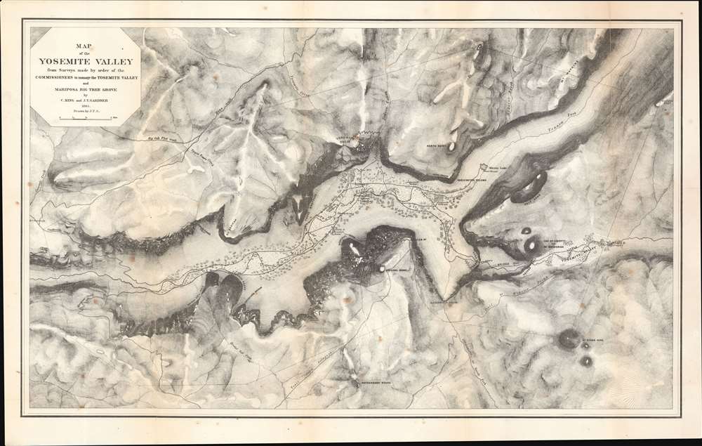
Map of the Yosemite Valley from Surveys made by order of the Commissioners to manage the Yosemite Valley and Mariposa Big Tree Grove.
1870 (dated) 17 x 26.75 in (43.18 x 67.945 cm) 1 : 32000
1870 (dated) 17 x 26.75 in (43.18 x 67.945 cm) 1 : 32000
Description
This is an 1870 Clarence King and James Terry Gardiner's detailed map of the Yosemite Valley, California, considered one of the earliest obtainable maps of that region. This map represents early government efforts under Frederick Law Olmsted and Josiah Dwight Whitney to map Yosemite as America's first reserved parkland. It offers superb detail, noting the Merced River, Virgin Tears, Yosemite Falls, Sentinel Rock and Dome, Bridal Veil Falls and Creek, Mariposa Trail and much more. Important builds on the valley floor also appear - including Yosemite's first two tourist hotels!
Two young graduates from Yale's Scientific School, Clarence King and James Terry Gardiner, were assigned to the task. While a government effort, the King-Gardner survey was actually paid for by Frederick Law Olmsted, famed designer of New York City's Central Park. As the nation's premier park expert Olmsted was harnessed by the Lincoln administration to draft a charter and plan for Yosemite. Eager to get some-sort of map of the valley, Olmsted used his own personal finances to complete the survey before winter - with the expectation that he would later be reimbursed by the state (he was).
The initial survey was basic and offered only a loose sketch encompassing Yosemite Valley's shape and proportions. Of the valley floor itself, little detail was included, but the cliffs were well mapped with hachure. In 1867, Charles F. Hoffman led a second survey expedition that included both King and Gardiner, to fully survey the valley floor. This data found its way into the 3rd, 4th, and 5th states of the present map - as here.
Surveying Yosemite
The Yosemite Grant passed Congress on June 30, 1864, after which it was promptly signed into law by President Abraham Lincoln. This is the first instance of land being set aside specifically for preservation and public use by the U.S. federal government and set a precedent for the 1872 creation of Yellowstone. The grant created an urgent need for a survey of the ceded lands before winter set in.Two young graduates from Yale's Scientific School, Clarence King and James Terry Gardiner, were assigned to the task. While a government effort, the King-Gardner survey was actually paid for by Frederick Law Olmsted, famed designer of New York City's Central Park. As the nation's premier park expert Olmsted was harnessed by the Lincoln administration to draft a charter and plan for Yosemite. Eager to get some-sort of map of the valley, Olmsted used his own personal finances to complete the survey before winter - with the expectation that he would later be reimbursed by the state (he was).
The initial survey was basic and offered only a loose sketch encompassing Yosemite Valley's shape and proportions. Of the valley floor itself, little detail was included, but the cliffs were well mapped with hachure. In 1867, Charles F. Hoffman led a second survey expedition that included both King and Gardiner, to fully survey the valley floor. This data found its way into the 3rd, 4th, and 5th states of the present map - as here.
Publication History and Census
The map was printed in New York by Julius Bien in 1870 for Josiah Dwight Whitney's Geological Survey of California Yosemite Guide-Book. Although Gardner drafted the map in 1865, it remained unpublished until 1868. It subsequently appeared in 5 states, this being the 3rd:- State 1: 1868, Geological Survey of California, J. D. Whitney, The Yosemite Book (New York: Julius Bien, 1868) (Farquhar 7a). This state is distinguishable by green overprinting in the valley.
- State 2: 1868, Geological Survey of California, J. D. Whitney, The Yosemite Guide-Book (Farquhar 7b). Similar to the above but lacking the overprinting.
- State 3: (Present Example) 1870, Geological Survey of California, J. D. Whitney, The Yosemite Guide-Book (Farquhar 7c). This edition bears significant updates from Charles F. Hoffmann's 1867 survey of the valley. The river is shown correctly, along with the Yosemite Creek fan below the falls. Buildings, roads, and orchards have also been added.
- State 4: 1872, A. L. Bancroft produced a variant of State 3, with his own imprint and a reintroduction of the green overprinting.
- State 5: 1874, A separate issue on heavy paper, expanded and revised.
CartographerS
James Terry Gardiner (May 6, 1842 - September 10, 1912), sometimes spelled 'Gardner', was an American surveyor and engineer. Gardiner was born in Troy, New York. He studied at the nearby Rensselaer Polytechnic Institute, and afterwards at the Sheffield Scientific School. In 1863, he joined a childhood friend and geologist Clarence King (January 6, 1842 - December 24, 1901), to travel cross country on horseback to San Francisco - an intimidating and arduous journey. There he worked with the United States Army Corps of Engineers as a civilian assistant and participated in the construction of fortifications on at Fort Mason and Angel Island. From 1964 he worked with the California Geological survey under Josiah Whitney (November 23, 1819 - August 18, 1896). Under Whitney, and often accompanied by King, he embarked on a series of important surveys, including the first scientific survey of the Yosemite Valley and the High Sierra. In 1867 he joined the Fortieth Parallel Survey, led by his friend King. From 1872 - 1876 he was the chief topographer for the Hayden Survey. Afterwards he took a position as director of the State Survey in New York. Meanwhile, he became involved in the mining industry, writing a report on coal and iron in Colorado (1875); serving as vice-president of the coal companies belonging to the Erie Railroad; and becoming president of the Mexican Coke and Coal Company in 1899. With his father-in-law, Bishop William Croswell Doane, he helped establish the community of Northeast Harbor on Mount Desert Island, Maine. There he built a large summer home named, Ye Haven. It still stands today. Gardiner died in Northeast Harbor. More by this mapmaker...
Clarence Rivers King (January 6, 1842 - December 24, 1901) was an American geologist, mountaineer, and author. King was born in Newport Rhode Island to a merchant family involved in the China trade. He developed an early interest in outdoor life, natural history, and geology - fields encouraged by both his mother and the head of the Christ Church Hall School of Pomfret, where he studied. From 13, he attended the prestigious Hartford High School, then Sheffield Scientific School (where he met James Terry Gardiner), and in 1860, Yale College. Graduating, he briefly moved to New York where he roomed with Gardiner, but the two quickly developed a plan to travel west on horseback. Following the wagon trains, they made their way to San Francisco, where both eventually took work with the California Geological Survey under Josiah Whitney (November 23, 1819 - August 18, 1896). In 1864 and 1865 they completed the first scientific survey of the Yosemite Valley and the High Sierra. In 1867 he conceived, planned, and led, along with Gardiner, the Fortieth Parallel Survey, during which he exposed the Diamond Hoax of 1872. From 1879 to 1881, he was the first director of the United States Geological Survey. In a bizarre twist, in the late 1880s King fell in love with Ada Copeland (1860 - 1964), an African American nursemaid and former slave from Georgia. Although he had light skin and eyes, King convinced her he was an African American railroad pullman worker named James Todd. They married in September 1888, having 5 children. Thus, King led a remarkable double life, at both the highest and lowest echelons of 19th century American society. After King died, Ada fought a legal battle to collect his inheritance, which ultimately failed. Nonetheless, former friends of King, particularly John Hay, stepped up to support Ada until her death at the impressive age of 104. King himself died of tuberculosis in Phoenix, Arizona, and was buried in Newport, Rhode Island. Learn More...
Julius (Julien) Bien (September 27, 1826 - December 21, 1909) was a German-Jewish lithographer and engraver based in New York City. Bien was born in Naumburg, Germany. He was educated at the Academy of Fine Arts, Cassell and at Städel's Institute, Frankfurt-am-Main. Following the suppression of the anti-autocratic German Revolutions of 1848, Bien, who participated in the pan-German movement, found himself out of favor in his home country and joined the mass German immigration to the United States. Bien can be found in New York as early as 1849. He established the New York Lithographing, Engraving & Printing Company in New York that focused on the emergent chromo-lithograph process - a method of printing color using lithographic plates. His work drew the attention of the U.S. Government Printing Office which contracted him to produce countless government maps and surveys, including the Pacific Railroad Surveys, the census, numerous coast surveys, and various maps relating to the American Civil War. Bien also issued several atlases both privately and in conjunction with a relation, Joseph Bien. At the height of his career Bien was elected president of the American Lithographers Association. After his death in 1909, Bien's firm was taken over by his son who promptly ran it into insolvency. The firm was sold to Sheldon Franklin, who, as part of the deal, retained the right to publish under the Julius Bien imprint. In addition to his work as a printer, Bien was active in the New York German Jewish community. He was director of the New York Hebrew Technical Institute, the New York Hebrew Orphan Asylum, and president of the B'nai B'rith Order. Learn More...
Source
Whitney, J. D., The Yosemite Guide-Book, 1870.
Condition
Very good. Some foxing. a couple of minor edge reinforcements.