This item has been sold, but you can get on the Waitlist to be notified if another example becomes available, or purchase a digital scan.
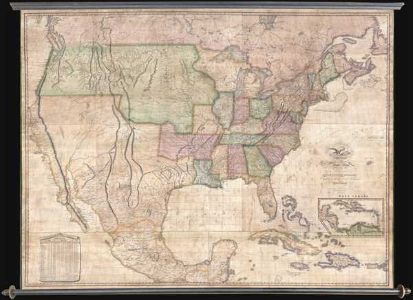
1822 Melish Wall Map of the United States
UnitedStates-melish-1822$22,500.00

Title
Map of the United States with the Contiguous British & Spanish Possessions Compiled from the latest & best authorities by John Melish . . . Improved to 1822.
1822 (dated) 44 x 60 in (111.76 x 152.4 cm) 1 : 3800000
1822 (dated) 44 x 60 in (111.76 x 152.4 cm) 1 : 3800000
Description
An example of John Melish's important 1822 map of the United States. Melish's map is considered the most influential map of American published in the 19th century and is rivaled only by John Mitchell's 1755 map of North America as the single most influential map in American history. It is the first map to show the United States extending from Atlantic to Pacific and as such is considered by many historians to be the visual embodiment of Manifest Destiny. Manifest Destiny, a concept referring to the inevitability of the growth of the United States across the entire continent, was not current until the 1840’s, there can be little doubt that this powerful cartographic image was prophetic in presaging the idea. Much like the Mitchell Map before it, this map was used in numerous border negotiations and peace treaties, thus indelibly leaving its mark on the geographical evolution of the United States.
Melish first published this map in 1816. In 1818, he wrote in the maps' prospectus, of the moment of inspiration that led to his first 'coast to coast' map of the United States.
Melish's map enjoyed immediate success. From his retirement home at Monticello, no less than Thomas Jefferson wrote in praise of the map, describing it as a 'luminous view of all the comparative possessions of different powers in our America.' Jefferson was also duly impressed by the map's coast-to-coast magnitude believing that the founding of the Astoria Trading Post on the Columbia River sufficient to extend American sovereignty to 'all its waters.'
Melish was determined that the map be as up to date as possible and, as a well-established mapmaker during period of rapid expansion, exploration, and political change, understood just how difficult this is. Thus to keep on top of these many developments, Melish devised a plan wherein
The present example is the second 1822 edition or state (Martin 21, Ristow 23). This edition follows the second 1820 state (Martin 13, Ristow 15) in which three additional sheets are added to the bottom to detail a newly independent Mexico and West Indies. Melish justification of this addition was published in the 1826 posthumous edition of Geographical Description,
This edition was engraved by John Vallance and Henry S. Tanner , two of the finest engravers active in the United States. The present example is a scarce presentation in wall map format - almost all other examples of Melish's map we've see have been in dissected case format.
All editions of Melish's great map are extremely scarce due to the low print run, which was capped at 100, and the rigours of use in public buildings and schools. Many were simply destroyed as subsequent editions supplemented them. We are aware of only one other example of this specific state to have appeared on the market in the last 20 years.
Melish first published this map in 1816. In 1818, he wrote in the maps' prospectus, of the moment of inspiration that led to his first 'coast to coast' map of the United States.
During the progress of the war [of 1812], a very respectable Friend in Philadelphia, when talking of the Map of the Seat of War, said 'I wish friend John, thee would make a Map of t Seat of Peace.' The hint was not lost. The author had seen the good effects of maps, particularly when accompanied by descriptions, and he resolved to condense into one grand view the whole of the United States territory, including the British Possessions and Spanish Possessions contiguous to it, to be ready as soon as possible after these regions became the 'Seat of Peace.'Melish originally intended to
…carry the map no further west than the ridge dividing the waters falling into the Gulf of Mexico, from those falling into the Pacific Ocean.A subsequent view of the subject pointed out the propriety of adding two western sheets as to carry it to the Pacific Ocean.The innovative, even audacious, and expansive map thus produced was the first American commercial map to extend from coast-to-coast, incorporating in the process the discoveries of Lewis and Clark and Zebulon Pike, as well as elements from earlier maps by Alexander von Humboldt, Aaron Arrowsmith, and others.
Melish's map enjoyed immediate success. From his retirement home at Monticello, no less than Thomas Jefferson wrote in praise of the map, describing it as a 'luminous view of all the comparative possessions of different powers in our America.' Jefferson was also duly impressed by the map's coast-to-coast magnitude believing that the founding of the Astoria Trading Post on the Columbia River sufficient to extend American sovereignty to 'all its waters.'
Melish was determined that the map be as up to date as possible and, as a well-established mapmaker during period of rapid expansion, exploration, and political change, understood just how difficult this is. Thus to keep on top of these many developments, Melish devised a plan wherein
The map is printed off 100 at a time, and before a new hundred be printed, the plates are carefully revised, and if there be from for corrections or improvements, these are made accordingly.This result of this unique strategy is that both a that vast number of states appeared on the market and that all states are exceedingly rare. The map historian Col. Lawrence Martin identified some 22 separate editions or states. Walter Ristow revised this to 24. Today we are aware of no less than 26 known states, although there may be others.
The present example is the second 1822 edition or state (Martin 21, Ristow 23). This edition follows the second 1820 state (Martin 13, Ristow 15) in which three additional sheets are added to the bottom to detail a newly independent Mexico and West Indies. Melish justification of this addition was published in the 1826 posthumous edition of Geographical Description,
When the late treaty was negotiated with Spain which had reference to the map in fixing the southwest boundary, it was determined to bring forward an entire new edition of the Map, exhibiting Florida as part of the United States, and making all alternation that had taken place in the country, up to the time of publication; and from a conviction that Mexico would soon become independent, and would eventually be of great importance to the United States, it was determined to add another sheet exhibiting a complete view of that very interesting country, with all the most important West India Islands.This is notably the final edition of Melish's iconic map to be published in his lifetime. Melish died suddenly and unexpectedly in December of 1822. At least one, possibly two, posthumous editions were published in 1823, and possibly 1826, by John Finlayson. The second 1822 edition, offered here, features a number of revisions, including the addition of 'New California,' 'New Albion,' the designation of 'Internal Provinces' in northern Mexico, and the name 'Mexico.'
This edition was engraved by John Vallance and Henry S. Tanner , two of the finest engravers active in the United States. The present example is a scarce presentation in wall map format - almost all other examples of Melish's map we've see have been in dissected case format.
All editions of Melish's great map are extremely scarce due to the low print run, which was capped at 100, and the rigours of use in public buildings and schools. Many were simply destroyed as subsequent editions supplemented them. We are aware of only one other example of this specific state to have appeared on the market in the last 20 years.
CartographerS
John Melish (June 13, 1771 - 1822) was an early 19th century American writer, publisher and mapmaker based at 209 Chestnut Street, Philadelphia. Many historians consider John Melish to be the first truly great American commercial cartographer and responsible for some of the most influential maps in the history of North America. Melish was born in Scotland in 1771. As a young man he apprenticed to a Glasgow cotton merchant and in this capacity visited America no less than four times between 1798 and 1809. In 1806 Melish attempted to create his own cotton important-export company based in Glasgow, Scotland and Savannah, Georgia. Unfortunately, deteriorating relations between the United States and Great Britain resulted in the 1807 trade embargo, which all but destroyed Melish's fledgling company. In 1811 Melish finally left Scotland to permanently relocate in Philadelphia. Melish had never been truly satisfied with the quality of travel writing available regarding the new republic and so, in 1812, published his own contribution to the genre. Melish based his first major publication, the cartographically rich, Travels in the United States of America in the Years 1806 & 1807, and 1809, 1810 and 1811, on the copious notes taken during his own travels as a cotton merchant. Travels enjoyed an immediate success and even caught the eye of Thomas Jefferson, then President, who sent copies of the work to friends in France and Italy. Partially in an attempt to illustrate his own travels and partly in response to a general need for good cartographic materials, Melish turned to map publishing. By 1814 he was styling himself as a "Geographer and Map Seller" and had published several independent maps, geographies and gazetteers. Melish's most important work is most likely his iconic representation of the United States first published in 1816, Map of the United States with the contiguous British and Spanish Possessions. This visionary large format map was the first American commercial map to show the United States extending from coast-to-coast in a remarkably prescient expression of the Doctrine of Manifest Destiny. Melish died suddenly of unknown causes in December of 1822. He is buried in Philadelphia. (Carter, E. C., Surveying the Record, pages 40 - 49. Ristow, W., American Maps and Map Makers, pages 110-115. 143, 154, 166-168, 191, 246, 281, 446. Wolfgang, M.E., "John Melish: An Early American Demographer." Pennsylvania Magazine 82 (1958): pages 65-81.) More by this mapmaker...
Henry Schenck Tanner (1786 - May 18, 1858) was one of the preeminent American map engravers and publishers of the early 19th century - what is considered to be the "Golden Age of American Map Publishing". Born in New York City but based in Philadelphia, Tanner's forty plus year career was almost entirely focused on cartographic work. His earliest map work appears in conjunction with another important map publisher, John Melish. Early in his career, Tanner partnered with his brother Benjamin, to engrave extensively for Melish as well as other Philadelphia publishers including Lucas Fielding (Baltimore), A. Bourne, Jason Torey, Samuel Harrison, and Samuel Lewis, among others. In 1818 Tanner convinced his fellow publishers and partners to finance the compilation of a New American Atlas. The atlas was sold by subscription and slowly emerged between 1819 and 1823. The New American Atlas, possibly the pinnacle of 19th century American cartography and was commended in its day as "one of the most splendid works of the kind ever executed in this country". It was subsequently republished in several updated editions until about 1839. Tanner had by this time become the most active and influential map publisher in the United States. Around 1832, recognizing the market for a less cost prohibitive atlas, Tanner began work on the smaller format New Universal Atlas. This popular and important atlas went through numerous editions before being bought out by Carey and Hart, and then, in 1846, by S. A. Mitchell, who would rise to become the preeminent publisher of the next generation. In addition to these important atlases, Tanner also issued numerous extremely important and influential travelers guides, state maps, wall maps, and pocket maps. He should not be confused with his brother, also an America map engraver, the New Yorker Benjamin Tanner. Learn More...
Condition
Good. Wall map. Professionally restored. Originally rollers.
References
Ristow, W., American Maps and Mapmakers: Commercial Cartography in the Nineteenth Century, p183 - 189. Ristow, W., A la Carte, p162-182. Wolfgang, M.E., 'John Melish: An Early American Demographer.' Pennsylvania Magazine 82 (1958): pages 65-81. Carter, E. C., Surveying the Record, pages 40 - 49. Schwartz, S. and Ehrenberg, R., The Mapping of America, p238-239. Wheat, C. I., Mapping of the Transmississippi West, 1540 – 1861, no. 322.