1846 Mitchell Map of the United States
UnitedStates-mitchell-1846$325.00

Title
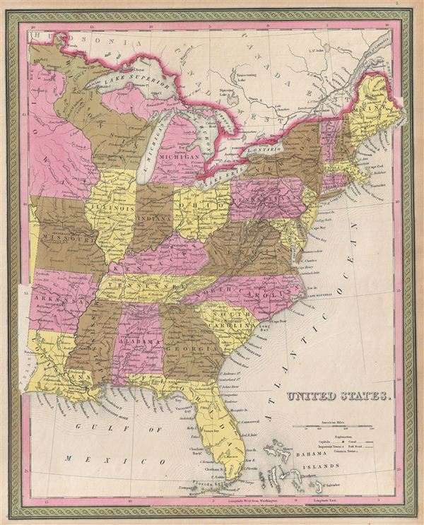
United States.
1846 (dated) 16 x 12.75 in (40.64 x 32.385 cm)
1846 (dated) 16 x 12.75 in (40.64 x 32.385 cm)
Description
A fine example of the 1846 first edition of Mitchell's map of the United States. This map covers the United States east of the Mississippi as well as the Trans-Mississippi territories of Louisiana, Arkansas, Missouri, and Iowa. The whole is engraved and colored in Mitchell's distinctive style with green border work and vivid pastels. Political and topographical features are noted and color coded with elevation rendered by hachure.
This ephemeral map details United States during a period of rapid development and westward expansion. Throughout the 1840s emigration and settlement to the west of the Mississippi led to a transformation of the national map. The present example focuses on the eastern portion of the country in the early days of the Mexican-American War. In the year of this map's publication, Texas joined the Union leading to U.S. invasion of Mexican California and the subsequent events of the Mexican-American War.
Mitchell derived this map from an earlier map of Michigan by H. S. Tanner, whose plates he acquired in 1846. engraved by H. N. Burroughs for publication as plate no. 5 in the 1846 first edition of S. A. Mitchell's New Universal Atlas.
CartographerS
Samuel Augustus Mitchell (March 20, 1792 - December 20, 1868) began his map publishing career in the early 1830s. Mitchell was born in Bristol, Connecticut. He relocated to Philadelphia in 1821. Having worked as a school teacher and a geographical writer, Mitchell was frustrated with the low quality and inaccuracy of school texts of the period. His first maps were an attempt to rectify this problem. In the next 20 years Mitchell would become the most prominent American map publisher of the mid-19th century. Mitchell worked with prominent engravers J. H. Young, H. S. Tanner, and H. N. Burroughs before attaining the full copyright on his maps in 1847. In 1849 Mitchell either partnered with or sold his plates to Thomas, Cowperthwait and Company who continued to publish the Mitchell's Universal Atlas. By about 1856 most of the Mitchell plates and copyrights were acquired by Charles Desilver who continued to publish the maps, many with modified borders and color schemes, until Mitchell's son, Samuel Augustus Mitchell Junior, entered the picture. In 1859, S.A. Mitchell Jr. purchased most of the plates back from Desilver and introduced his own floral motif border. From 1860 on, he published his own editions of the New General Atlas. The younger Mitchell became as prominent as his father, publishing maps and atlases until 1887, when most of the copyrights were again sold and the Mitchell firm closed its doors for the final time. More by this mapmaker...
Horatio Nelson Burroughs (June 28, 1812 - August 23, 1896) was an engraver and later a banker based in Pennsylvania and active in the early 19th century. He was born in Washington Crossing, New Jersey. Burroughs' work first appears in conjunction with Henry Schenk Tanner and Samuel Augustus Mitchell (the elder). His name appears on the 1846 copyrights of many of Mitchell's earliest and most important atlas and pocket maps. Following 1846, Burroughs retired from engraving to become a banker, eventually becoming president of Commonwealth Bank. He married first Eleanor Douglas Mitchell (18?? - 1853), then, after her untimely death, her sister Caroline Mitchell (1818 - 1892), both daughters of map and atlas publisher Samuel Augustus Mitchell Sr. (1792 - 1868). Learn More...
Source
Mitchell, S. A., A New Universal Atlas Containing Maps of the various Empires, Kingdoms, States and Republics Of The World, (Thomas Cowperthwait & Co., Philadelphia) 1846.
Condition
Very good condition. Blank on verso. Even overall age toning.