This item has been sold, but you can get on the Waitlist to be notified if another example becomes available, or purchase a digital scan.
1864 Mitchell Map of the United States
UnitedStates-mitchell-1864$99.50

Title
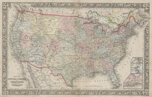
Map of the United States, and Territories, together with Canada & c.
1860 (dated) 13.5 x 21.5 in (34.29 x 54.61 cm)
1860 (dated) 13.5 x 21.5 in (34.29 x 54.61 cm)
Description
A fine example of Mitchell's 1864 map of the United States. Depicts the entirety of the continental United States along with parts of Canada and Mexico. Depicts the country in considerable detail with notations regarding railroads, mail routes (including the famed Pony Express Routes), emigrant routes westward, topographical, and political details. Represents the 1864 state of the map in which the Western states are presented in an early ephemeral configuration. Idaho embraces all of modern day Montana, and Wyoming. Arizona contains what is today the southern extension of Nevada, including Las Vegas, which is noted. Two insets in the lower right quadrant feature 'Hampton Roads and Norfolk Harbo'r as well as' Pensacola Bay.' One of the most attractive American atlas maps of the United States to appear in the mid 19th century. Features the floral border typical of Mitchell maps from the 1860-65 period. Prepared by S. A. Mitchell for inclusion as map nos. 9, 10 and 11 in the 1864 issue of Mitchell's New General Atlas. Dated and copyrighted, 'Entered according to Act of Congress in the Year 1860 by S. A. Mitchell Jr. in the Clerk's Office of the District Court of the U.S. for the Eastern District of Pennsylvania.'
Cartographer
Samuel Augustus Mitchell (March 20, 1792 - December 20, 1868) began his map publishing career in the early 1830s. Mitchell was born in Bristol, Connecticut. He relocated to Philadelphia in 1821. Having worked as a school teacher and a geographical writer, Mitchell was frustrated with the low quality and inaccuracy of school texts of the period. His first maps were an attempt to rectify this problem. In the next 20 years Mitchell would become the most prominent American map publisher of the mid-19th century. Mitchell worked with prominent engravers J. H. Young, H. S. Tanner, and H. N. Burroughs before attaining the full copyright on his maps in 1847. In 1849 Mitchell either partnered with or sold his plates to Thomas, Cowperthwait and Company who continued to publish the Mitchell's Universal Atlas. By about 1856 most of the Mitchell plates and copyrights were acquired by Charles Desilver who continued to publish the maps, many with modified borders and color schemes, until Mitchell's son, Samuel Augustus Mitchell Junior, entered the picture. In 1859, S.A. Mitchell Jr. purchased most of the plates back from Desilver and introduced his own floral motif border. From 1860 on, he published his own editions of the New General Atlas. The younger Mitchell became as prominent as his father, publishing maps and atlases until 1887, when most of the copyrights were again sold and the Mitchell firm closed its doors for the final time. More by this mapmaker...
Source
Mitchell's New General Atlas, containing Maps of the Various Countries of the World, Plans of Cities, Etc., Embraced in Fifty-three Quarto Maps, forming a series of Eighty-Four Map and Plans, together with Valuable Statistical Tables. (1864 Edition)
Condition
Very good condition. Minor discoloration and verso reinvorcement along original centerfold. Blank on verso.
References
New York Public Library, Map Division, 1510796.