This item has been sold, but you can get on the Waitlist to be notified if another example becomes available, or purchase a digital scan.
1791 Payne Map of the United States
UnitedStates-payne-1791$600.00

Title
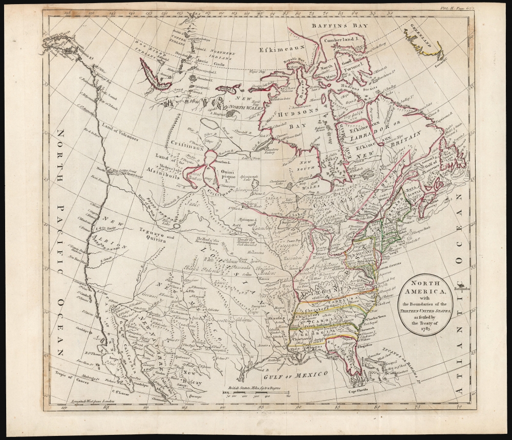
North America, with Boundaries of the Thirteen United States as settled by the Treaty of 1783.
1791 (undated) 13.5 x 14.5 in (34.29 x 36.83 cm) 1 : 17424000
1791 (undated) 13.5 x 14.5 in (34.29 x 36.83 cm) 1 : 17424000
Description
This is the 1791 John Payne map of the United States issued for his Universal Geography. It is among the earliest maps specifically of the newly formed United States, indicating its western border along the Mississippi River.
Unlike the Mitchell, this map extends beyond the United States to reach the Pacific. The French territory of Louisiana is shown beyond the western border, with the Spanish territories of New Mexico and New Navarre in the southwest. The California coast is labeled 'New Albion,' with 'Sr. Francis Drakes Harbour' noted clearly. Near 'Fuca's Entrance' at approximately 48º North is an extensive 'River of the North,' an early iteration of the Columbia River. These features likely follow the lead of English maps, such as those of Sayer and Bennett. The delineation of Lake Winnipeg (Ouinipique L .) is however, based on French sources, possibly Rigobert Bonne.
The open spaces of the west are, in many places, filled with descriptive notes: 'thus far the Mississippi has been ascended' and 'Buffaloes Meadows' share space with Native American tribal names, including the White and Black Padoucas, the Osages, and more.
A Closer Look
The map is based on the 1755 Mitchell wall map upon which the 1783 treaty ending the American Revolutionary War (1775 - 1783) was based. Accordingly, the states of Georgia, the Carolinas and Virginia extend the full span from the Atlantic to the Mississippi, reflecting old Colonial Grants. Virginia's border further encompasses the whole of the United States' northwest frontier, including what is now Michigan.Unlike the Mitchell, this map extends beyond the United States to reach the Pacific. The French territory of Louisiana is shown beyond the western border, with the Spanish territories of New Mexico and New Navarre in the southwest. The California coast is labeled 'New Albion,' with 'Sr. Francis Drakes Harbour' noted clearly. Near 'Fuca's Entrance' at approximately 48º North is an extensive 'River of the North,' an early iteration of the Columbia River. These features likely follow the lead of English maps, such as those of Sayer and Bennett. The delineation of Lake Winnipeg (Ouinipique L .) is however, based on French sources, possibly Rigobert Bonne.
The open spaces of the west are, in many places, filled with descriptive notes: 'thus far the Mississippi has been ascended' and 'Buffaloes Meadows' share space with Native American tribal names, including the White and Black Padoucas, the Osages, and more.
Publication History and Census
This map was prepared for inclusion in the second volume of John Payne's Universal Geography formed into a New and Entire System (London,1791). We are aware of a single institutional example of the separate map, held in the collection of the University of North Carolina. About forty examples of the atlas are listed in institutional collections.Cartographer
John Payne (fl. c. 1780 - c. 1800) was a little known cartographer and map publisher working in New York and Philadelphia in the last years of the 18th century. Nothing is known of his youth and education. He is known to have published Joseph Collyer's 1772 New System of Geography in London, and his own work is probably descended from Collyer's. Payne published, again in London, his two-volume Universal geography formed into a new and entire system in 1791. Dublin editions under this title appeared in 1792 and 1794, lacking maps and reducing the general geography to a glossary to make room travellers' tales, notably those of Hawkesworth: it is probably that Payne had nothing to do with the Dublin editions, which were almost certainly pirate editions. Sometime during the 1790s Payne emigrated to New York, where he would publish in 1798-9 Payne's New and Complete Universal Geography, one of the first examples of American - printed commercial cartography. More by this mapmaker...
Source
Payne, J., Universal geography formed into a new and entire system, (London: Johnson) 1791.
Condition
Good. One tiny area of text reinstatement, else very good with original outline color.
References
Not in OCLC. Not in Rumsey. McCorkle, B. A Carto-Bibliography of the Maps in Eighteenth-Century British and American Geography Books#325-23 (Vol II).