1845 Woodbridge Wall Map of the United States w/ Republic of Texas
UnitedStates-phelpsensign-1845$3,500.00

Title
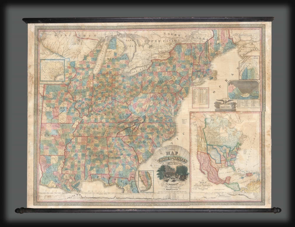
Map of the United States with the Recent Counties, Cities, Villages and Internal Improvements in the Western States.
1845 (dated) 46.25 x 53.25 in (117.475 x 135.255 cm) 1 : 1900800
1845 (dated) 46.25 x 53.25 in (117.475 x 135.255 cm) 1 : 1900800
Description
An impressive 1845 Phelps and Ensign map of the United States with an inset of the newly formed Republic of Texas. This map is a much revised and updated variant on the 1817 Varlé map, and more specifically, the 1832 Stebbins / Varlé reissue. It stands out for its inclusion of the Republic of Texas as an inset. The map also illustrates U.S. claims to British Columbia - part of the Oregon Question or 54-40 border debate between the United States and British North America.
The Texas depicted here uses the Neuces River as a western boundary. Austin's colony and its borders are noted, as are a few of the larger towns.
A Closer Look
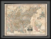
The map covers the settled part of the United States before the Mexican-American War (1846 - 1847), stretching from the Atlantic seaboard west to encompass Missouri, Arkansas, and Louisiana, and from Ontario and the Great Lakes to Florida. Northern Maine and southern Florida are illustrated as insets - as is the newly formed Republic of Texas. Along the bottom of the map an elevation chart stretches from Atlantic to Pacific. A secondary table in the upper right illustrates the comparative heights of the great North American mountains. A large inset in the lower right covers the whole of North America, illustrating American claims to British Columbia, but not the boundaries of the Republic of Texas. The decorative cartouche, at bottom center, illustrates the Erie Canal at Little Falls, New York. An interesting table near New Jersey provides town, state, and territorial populations, breaking out the slave population in each, thus marking a clear divide between Free and Slave states.Republic of Texas
The Republic of Texas was a short-lived nation established in March 1836 when it seceded from Mexico. Following the independence of Mexico from Spain, the American Stephen Fuller Austin led a group of 300 Empresarios to settle Texas, near Austin, where they received a grant from the Mexican government. As more Americans moved to Texas, resentment and strife began to build between the American settlers and Mexican authorities. This and other factors ultimately led to the Texan Revolution in 1835 and the declaration of Texan independence in 1836. Texas remained an independent republic until it joined the United States ten years later in 1846.The Texas depicted here uses the Neuces River as a western boundary. Austin's colony and its borders are noted, as are a few of the larger towns.
54-40 or Fight! American Claims to British Columbia
Following the transcontinental crossing of North America by the British Northwest Company sponsored explorer Alexander MacKenzie (1792 - 1793) and the American expedition of Lewis and Clark up the Missouri to the mouth of the Columbia River (1804 - 1806), it became apparent that control of the fur and resource rich Pacific Northwest would bring great wealth and power to whoever could assert sovereignty. The American tycoon John Jacob Astor, with the permission of President Thomas Jefferson, was the first to attempt a permanent trading colony in the region, founding Astoria on the Columbia River in 1811. This quickly led to a confrontation with the established British-Canadian Northwest Company over this valuable territory. Americans in the 1820s through the 1840s argued that most of the Pacific Northwest should be part of the United States as a legacy of the 1803 Louisiana Purchase. England, on the other hand, argued for residual claims to the region derived from the MacKenzie Expedition and its fur trading empires: The Northwest Company and the Hudson Bay Company. The Oregon Dispute, as it came to be known, became an important geopolitical issue between the British Empire and the United States, especially after the War of 1812. Americans adopted the slogan '54-40 or Fight!' until the Oregon Question was finally resolved roughly along the current border by the 1846 Oregon Treaty.Publication History and Census
This map first appears in 1817, where it is attributed to Charles P. Varlé. The plates were updated and revised in 1832 by R. Stebbins with new content and the Erie Canal at Little Falls cartouche, though that issue retained the Varlé imprint. When Varlé died in 1835, the plates were acquired by Phelps and Squire, who issued an 1836 edition without Varlé's imprint - adding the newly formed Republic of Texas as an inset. Of Woodbridge, who presumably updated the map, we can find no trace. We note subsequent editions in 1845 (present example) and 1847 by Phelps and Ensign.CartographerS
Humphrey Phelps (1799 - 1875) was an American map, broadside, and book publisher based in New York City. Phelps was born in 1799 in Hebron, Connecticut. Phelps' earliest work seems to be a plan of New York City for his Stranger's Guide, dating to about 1830. Between 183- and 1837 he published with Bela Scovil Squire (1786 - 1861) under the imprint of Phelps and Squire. The New York map publishing circle seems to have been quite close and Phelps commonly partnered with various other New York publishers and printers including Edward H. Ensign (1818 - 1871), Horace Thayer, Erastus Clark Bridgman (1817 - 1870), Thomas C. Fanning (1805 - 1873), Hooker, Peabody, Charles Magnus, Gaylord Watson, and George Walker, among others. The natural consequence of his rampant partnering is a vast and varied corpus of work including many scarce items with low print runs. Phelps is best known for his emigrant and tourist guides. More by this mapmaker...
Edward Hooker Ensign (August 18, 1818 - July 10, 1871) was an American map and print publisher based in New York during the middle part of the 19th century. Edward was born in West Hartland, Connecticut. Little is known of Ensign's training but he may have inherited his business from his father, Timothy Ensign (1795 - 1859), who was a map publisher active in New York. Ensign seems to have had a flair for partnerships and variously published with Humphrey Phelps (1799 - 1875), Horace Thayer, Thomas C. Fanning (1805 - 1873) and Erastus C. Bridgman (1817 - 1870), among others. His various imprints include 'Phelps and Ensign' (1841-1844), 'T. and E. H. Ensign' (1844-1848), 'Ensign and Thayer' (1849), 'Ensign, Thayer, and Company' (1850-1851), 'Horace Thayer and Company' (1852), and 'Ensign, Bridgman and Fanning' (1854-1863). It appears that father and son worked together for some time as well, publishing as either 'T. and E. H. Ensign' or 'Ensigns'. At least some of these companies maintained offices in both Buffalo and New York City. Learn More...
Peter Charles Varlé (also known as Charles Peter Varlé (c. 1770 - 1835) was a French draughtsman, cartographer, and engineer active in the United States. He was born in toulouse in southern France and left France for Hispaniola (Santo Domingo) at the beginning of the French Revolution. He lived on Hispaniola and worked as an engineer until 1794, when he was forced to flee by the uprising of 1794. He moved to the United States and published a renowned plan of Philadelphia in 1796, along with a second edition in 1802. Varlé lived in Maine in 1795, and later in Massachusetts. He again lived in Philadelphia from 1797-98, and then moved to Baltimore, where he spent the rest of his days, except for time spent in Philadelphia in 1802. Learn More...
Condition
Good. Full professional restoration. Devarnished and relined with fresh linen. Color refreshed. Some infill here and there.
References
Rumsey 5463.000 (1845), 5468.000 (1832), 5471.000 (1817).