This item has been sold, but you can get on the Waitlist to be notified if another example becomes available, or purchase a digital scan.
1799 Poirson Map of the United States
UnitedStates-poirson-1799$650.00

Title
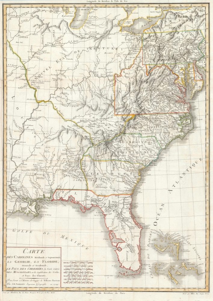
Carte des Carolines Meridionale et Septentrionale, La Georgie, La Floride, Orientale et Occidentale, Le Pays des Cherokees, la Vaste Contree des Muscogulges, ou la Confederation des Creks et Pays des Chataws.
1799 (dated) 25.5 x 18 in (64.77 x 45.72 cm) 1 : 3500000
1799 (dated) 25.5 x 18 in (64.77 x 45.72 cm) 1 : 3500000
Description
A beautiful 1799 example of Jean Baptiste Poirson's map of the American Southeast. This map was engraved to illustrate the 1799 first French edition of the naturalist William Bertram's travel narrative describing his explorations in the American Southeast.
A Closer Look
Coverage extends from the Mississippi River to the Atlantic and from Lake Michigan to the Florida Keys and extends no further east than the Delaware River. Cartographically, the topography and river systems are exceptionally well-developed. Settlement is generally limited to lands east of the Allegheny Mountains. Reflecting Bertram's travels, scores of Indian villages are located in the southwestern frontier (present-day Alabama and Mississippi) and Florida. Curiously, the name 'Nouvel Etat de Kentucky' has been applied to the entire territory northwest of the Tennessee River (here R. de Cherokees), as far as Lake Michigan.William Bartram
William Bartram was an American Naturalist of Pennsylvania Quaker descent. Bartram was appointed Royal Botanist for North America by King George III in 1765 and toured the American Southeast shortly thereafter. In 1773, he embarked upon a second historic exploration of the American Southeast, traveling through parts of Georgia, the Carolinas, and Florida - as covered on this map. Along the way, he recorded flora, fauna, and interactions with Native American peoples, notably the Creek, Cherokee, and Choctaw. He collected some 200 botanical specimens and made countless sketches. Among his discoveries are a tree species he named after Benjamin Franklin (a friend), the Franklin Tree or Franklinia Alatamatha. The Franklin Tree population was decimated by cotton pathogens from the nearby plantations and is now extinct in the wild but survives in cultivation.Publication History and Census
This map was first published in the 1799 French edition of Bertram's Travels through North and South Carolina, Georgia, East and West Florida. The 1791 English first edition did not contain a similar large map of the United States. It was republished in a revised 1800 edition, also in French. The map is held by several institutions, as are French editions of Bertram's work, but the separate map is rare to the market.Cartographer
Jean-Baptiste Poirson (March 6, 1761 – February 12, 1831) was a French engineer, globe-maker, geographer, and cartographer active in the late 18th and early 19th centuries. Poirson was born in Vrécourt (Vosages), France, the son of the town's master blacksmith, Pierre Poirson. Completing his studies in mathematics, Poirson took a position with the map publisher Edme Mentelle (1730 - 1815). From about 1790, maps begin appearing under the Poirson imprint. Having attained some recognition for correcting the work of earlier geographers, Porison was part of a team that collaborated on a large terrestrial globe for the instruction of the Dauphin. After 1803, he was again called on to produce an updated globe, this time for Napoleon Boneparte (this globe is preserved at Fontainebleau). Among his more significant works are the maps associated with the French edition of Alexander von Humboldt's Atlas Geographique Et Physique Du Royaume De La Nouvelle-Espagne. He also worked with Conrad Malte-Brun (1775 - 1826) and François-Raymond-Joseph de Pons (1751 - 1812). In 1825, Poirson and his wife settled in Valence-en-Brie (Seine-et-Marn), purchasing a house on the main street, today's Rue André-Taboulet. He died there in1831 and was survived by his son, the famous French playwright Charles-Gaspard Delestre-Poirson (1790 – 1859). More by this mapmaker...
Source
Bertram, W., Illustrations de Voyage dans les parties sud de l'Amérique septentrionale…, (Paris: Carteret and Brosson, Dugour, and Durand) 1799.
Condition
Very good. Left margin extended. Some wear on original fold lines. Light foxing.
References
OCLC 6344245. Phillips (America) pg. 872. Stevens Catalogue of Rare Books Relating to America 1617. Howes, W., U.S.iana (1650-1950): A Selective Bibliography in which are Described 11,620 Uncommon and Significant Books Relating to the Continental Portion of the United States, B223. Sabin, J., A Dictionary of Books Relating to America: from its Discovery to the Present Time, 3870. Streeter Sale 2:1088. Field 94.