
1922 Poole Bros. Wall Railroad Map of the United States, Illinois Central Railroad

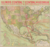
Illinois Central Yazoo and Mississippi Valley Central of Georgia Ocean Steamship Co. of Savannah.
From the Midwest to Midway.
- Digital Map Information
- Suitable for large format printing
- Full resolution TIFF file
- ICC color profile embedded
- Delivered instantly via download link
From the Midwest to Midway.
This is a striking, large-format 1922 Poole Brothers map of the United States produced for the Illinois Central Railroad and affiliated railroads. In addition to promoting the Illinois Central network, the map is also notable for demonstrating the increasingly global economic reach of the United States.A Closer Look
The map depicts the continental United States, along with a small portion of Canada, Mexico, the Caribbean, Central America, and the northern part of South America. The railroad routes of the Illinois Central and its subsidiaries are highlighted in red, with stops labeled. Major stops are highlighted in red. Beyond the Illinois Central line, an array of associated lines are traced in black. Maritime routes from New Orleans and Savannah are also traced, with distances noted, reaching destinations throughout the Caribbean and as far as India, Japan, China, and the Philippines. Insets surround the main map at bottom and right, including the Philippines, Guam, Hawaii, Wake Island, Midway Islands, Howland Island, Baker Island, a portion of the Samoan Islands, Puerto Rico, the Isle of Pines (New Caledonia), Cuba, and Alaska. At bottom-right is a chart with a table of distances from New Orleans.The map is notable for highlighting the increasing scope of American economic preponderance, linking the agricultural markets of the Midwest and Mississippi Valley to other parts of the country and international markets. The country's similarly expansive geographic self-conception is also apparent, including territories captured during the Spanish-American War (April 21 - August 13, 1898), and small but strategically important outposts in the Pacific such as Howland Island, Baker Island, and Wake Island.
The Illinois Central Railroad
The Illinois Central Railroad was the first land grant railroad in the United States, supported by such varied personages as Senator Stephen A. Douglas and the future President Abraham Lincoln, who was on retainer as the railroad's lawyer in the years prior to his Presidency. Despite being incorporated in 1836, the Federal land grant permitting the railroad's construction was not approved until 1850. It was subsequently chartered in 1851 and, at the time of its completion in 1856, it was the longest railroad in the world, linking Chicago to Cairo and Galena, Illinois. In the decades that followed, the Illinois Central expanded into a major national system, extending southward into Kentucky, Tennessee, Mississippi, and Louisiana, reaching New Orleans by 1870 and becoming known as the 'Main Line of Mid-America.' The railroad played a key role in the agricultural economy, transporting corn, wheat, and cotton, as well as passengers traveling between the North and South. In the 20th century, the Illinois Central became a pioneer in dieselization and streamlined passenger service, notably with its 'City of New Orleans' service, immortalized in song. Unlike many of its contemporaries, the Illinois Central survives today as a freight railway and subsidiary of the Canadian National Railway, with its passenger services having been taken over by Amtrak in 1971.The Yazoo and Mississippi Valley Railroad
The Yazoo and Mississippi Valley Railroad was incorporated in 1882 as part of the Illinois Central Railroad. The original line ran from Jackson, Mississippi, to Yazoo City, Mississippi, but was later expanded through the Mississippi Delta to Memphis, Tennessee. Several acquisitions in the following years steadily increased Illinois Central trackage and led to the founding of the Louisville, New Orleans, and Texas Railway.The Yazoo and Mississippi Valley - or its predecessor, the Yazoo Delta Railway - features in quite a few blues songs as the 'Yellow Dog Railroad.' Apparently, locals assigned the words 'Yellow Dog' to the Y.D. (Yazoo Delta) painted on the line's freight cars. The Yazoo and Mississippi Valley depot at Rosedale, Mississippi, has been designated as a site on the Mississippi Blues Trail. The marker commemorates the original lyrics of legendary blues artist Robert Johnson's 'Traveling Riverside Blues,' which traced the route of the Yazoo and Mississippi Valley. 'Traveling Riverside Blues' has been covered by several other musicians, including Led Zeppelin and Eric Clapton.
The Central of Georgia Railway
The Central of Georgia Railway was chartered in 1833 as the Central Rail Road and Canal Company of Georgia and became one of the earliest and most significant rail systems in the American South. Its initial goal was to connect the port city of Savannah with the interior cotton-producing regions of Georgia, providing a faster, more efficient route to market than river transport. By the 1840s, the line reached Macon, and over the following decades it expanded westward toward Columbus and northward to Atlanta, forming a vital network that linked Georgia's agricultural heartland with its coastal gateway. The Central of Georgia became a major economic force in both the antebellum and Reconstruction-era South, supporting the cotton trade and later diversifying to carry manufactured goods and passengers. Headquartered in Savannah, it maintained strong financial and social ties to that city's mercantile elite.To complement its rail operations and strengthen Savannah's role as a major port, the Central of Georgia established the Ocean Steamship Company of Savannah in 1872. This wholly owned subsidiary operated a fleet of steamships that carried freight and passengers between Savannah, New York, Boston, and, later, Philadelphia, integrating rail and maritime transport in a seamless network. The 'Savannah Line,' as it was often called, helped the Central of Georgia compete with other Southern railroads for long-distance trade and boosted Savannah's importance as a commercial hub.
In 1907, the Central of Georgia and the Ocean Steamship Company of Savannah were loosely incorporated into the Illinois Central network when the latter company's leading investor E. H. Harriman (1848 - 1909) also gained a controlling interest in the Central of Georgia. In the subsequent decades, as both steamships and railroads faced difficulties on several fronts, the Ocean Steamship Company of Savannah was wound down while the Central of Georgia changed hands several times, eventually being incorporated into the Norfolk Southern system in 1982.
Publication History and Census
This map was prepared by the Chicago firm Poole Brothers in 1922 for the Illinois Central. Several editions of a map similar to the present one were printed by Poole Brothers for the Railroad between 1897 and 1925, often with substantial updates (see, for comparison, our IllinoisCentral-poole-1897). It appears there were three printings of the map in 1922, distinguished by the small product number and date to the left and right of the copyright information along the bottom border; the earliest being 5571 and dated 3-10-'22, the second (the present map) being 6307 and dated 3-24-'22, and the latest being 5571A, dated 5-23-'22. Regardless of printing, the 1922 edition of the map is only noted among the holdings of four institutions in the OCLC: the University of Texas Arlington, the Wisconsin Historical Society, the University of Michigan, and the University of Missouri - St. Louis, with the latter two institutions cataloging the printing of the map seen here.Cartographer
Poole Brothers (1878 - 1968) were a Chicago based firm active in the late 19th and early 20th century with an initial focus on promotional railroad maps. Poole Brothers was founded by George Amos Poole (March 20, 1843 – September 7, 1918). In 1868, Poole, along with his uncle William H. Rand (1828 - 1915) and Andrew McNally (1836 - 1904), purchased the Chicago Tribune's job printing plant and formed the firm Rand McNally. In 1878, he left Rand McNally to form, with his brother William H. Poole, Poole Brothers, a direct competitor to Rand McNally for the lucrative railroad business. Like many of its competitors, Poole Brothers maintained an office on Chicago's Printer's Row (downtown Loop district). Their earliest known work is an 1880 map of Yellowstone National Park. In 1887, Poole Brothers, Andrew McNally, and several others formed the United Typothetae of America, a master printers association. In 1848, they were cited, along with Rand McNally and George Cram, by the Federal Trade Commission for price fixing. Their earliest known work is an 1880 map of Yellowstone National Park. Afterward they went on to produce a vast range of maps and other print products including tickets, cards, coupons, and restaurant menus. In time Poole Brothers merged with Newman-Randolph, which was then acquired by the American Can Company in the early 1960s. The American Can Company liquidated its printing concerns later in the same decade. Further Details...
Condition
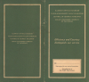
Very good. A few minor verso repairs to closed tears and to reinforce fold intersections. Closed edge tear professionally repaired on verso. Detached from but accompanied by original binder.
References
OCLC 587446100. Alternate printings OCLC 956779821, 701383900.