1862 Smith Map of the United States During the American Civil War
UnitedStates-smith-1862$1,950.00

Title
Map of the United States of North America, Upper and Lower Canada, New Brunswick, Nova Scotia and British Columbia. Mexico, Cuba, Jamaica, St. Domingo and the Bahama Islands.
1862 (dated) 27.25 x 38.5 in (69.215 x 97.79 cm) 1 : 5702400
1862 (dated) 27.25 x 38.5 in (69.215 x 97.79 cm) 1 : 5702400
Description
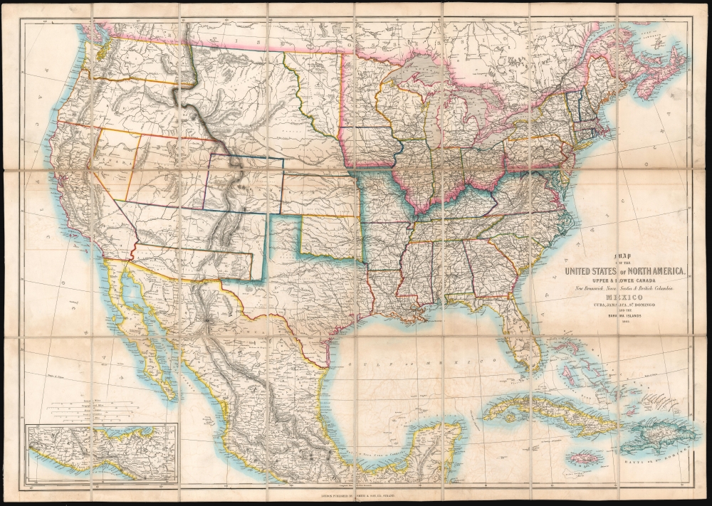
This is an 1862 'Smith and Son' map of the United States during the American Civil War (1861 - 1865). Although ostensibly from a 'neutral' perspective, the map reflects British interest in the conflict, which was significant as the Union blockade of the Confederacy drove the important British textile industry into ruin.
At the beginning of the Civil War, support for the Confederacy ran high in the southern parts of the New Mexico Territory. Local concerns drove this sentiment, including a belief that the war would lead to insufficient Federal troops to protect the citizens from the Apache. In contrast, others felt neglected by Washington. Also, the Butterfield Overland Mail Route (an overland mail and stagecoach route from Memphis and St. Louis to San Francisco) was closed in 1861, depriving the people of Arizona of their connection to the rest of the country.
All of these factors led to the people of the southern New Mexico Territory, or the Arizona Territory, to formally call for secession. A secession ordinance was adopted on March 16, 1861, with a subsequent ordinance ratified on March 28, establishing the provisional territorial government of the Confederate 'Territory of Arizona'. Confederate Arizona was proclaimed on August 1, 1861, following Lieutenant-Colonel J. R. Baylor's victory over Union forces in the First Battle of Mesilla. The Confederacy recognized the territory on February 14, 1862. However, by July 1862, Union forces from California, known as the 'California Column,' were marching on the territorial capital of Mesilla. Sent to protect California from a possible Confederate incursion, the 'California Column' drove Confederate forces out of the city, allowing them to retreat to Franklin, Texas. The territorial government also fled and spent the rest of the war in 'exile .'First, they retreated to Franklin, then, after Confederate forces abandoned Franklin and all of West Texas, to San Antonio, where the 'government-in-exile' spent the rest of the war. Confederate units from Arizona fought throughout the war, and the delegates from Arizona attended both the First and Second Confederate Congresses.
A Closer Look
Coverage embraces from the Pacific to the Atlantic, and from Canada (labeled as British Possessions) to the Yucatan and West Indies. The railroad network throughout the eastern United States is illustrated in detail. Further west, prospective railroads are noted, including the proposed transcontinental routes.The American Civil War - The Union and the Confederacy
Capturing a pivotal moment in American history, the geography presented here encapsulates both the fluid nature of the period and the unclear boundaries of the American West. The Union and the Confederacy are starkly divided. The Confederacy, most of the American southeast, is bordered in a bright blue, while red highlights the Union.Western Geography
As illustrated here, neither the Union nor the Confederacy extend into the western territories, except Texas, which was firmly a Confederate State. Maps of the United States in 1862 vary in their depiction the western territories, although some events are notably concrete. These include the admission of Kansas as a state on January 29, 1861, and the organization of the Colorado Territory on February 28, 1861. The boundaries of the Washington Territory and Oregon, which was admitted as a state in 1859, are illustrated in their territorial configurations. Others, such as the boundaries of the Nebraska Territory, the unincorporated Dakota or Dacotah Territory, and the Nevada, New Mexico, and Utah Territories, are much more fluid. Perhaps the most intriguing is the inclusion of Confederate Arizona and the 'L' shape of the New Mexico Territory, a curiosity we have not encountered on any other map.Confederate Arizona
Confederate Arizona was a territory claimed by the Confederate States of America from 1861 until 1865. The idea for an Arizona Territory appeared as early as 1856. The government of New Mexico Territory could not effectively govern the southern part of the territory, as it was separated from Santa Fe by the Jornada del Muerto, an unforgiving stretch of desert. The New Mexico territorial legislature acted on these concerns in February 1858, approving a resolution in favor of creating an Arizona Territory, with a north-south border along the 32nd meridian (from Washington). In April 1860, impatient for action, 31 delegates of southern New Mexico met at a convention in Tucson. There, they drafted a constitution for the 'Territory of Arizona', to be separated from New Mexico below the 34th parallel. The convention elected a territorial governor and a delegate to Congress. Congress, however, was reluctant to act. Anti-slavery Representatives recognized that the proposed territory would be a potential slave state under the Missouri Compromise. Congress never ratified the proceedings of the Tucson convention, and the Provisional Territory was never considered a legal entity.At the beginning of the Civil War, support for the Confederacy ran high in the southern parts of the New Mexico Territory. Local concerns drove this sentiment, including a belief that the war would lead to insufficient Federal troops to protect the citizens from the Apache. In contrast, others felt neglected by Washington. Also, the Butterfield Overland Mail Route (an overland mail and stagecoach route from Memphis and St. Louis to San Francisco) was closed in 1861, depriving the people of Arizona of their connection to the rest of the country.
All of these factors led to the people of the southern New Mexico Territory, or the Arizona Territory, to formally call for secession. A secession ordinance was adopted on March 16, 1861, with a subsequent ordinance ratified on March 28, establishing the provisional territorial government of the Confederate 'Territory of Arizona'. Confederate Arizona was proclaimed on August 1, 1861, following Lieutenant-Colonel J. R. Baylor's victory over Union forces in the First Battle of Mesilla. The Confederacy recognized the territory on February 14, 1862. However, by July 1862, Union forces from California, known as the 'California Column,' were marching on the territorial capital of Mesilla. Sent to protect California from a possible Confederate incursion, the 'California Column' drove Confederate forces out of the city, allowing them to retreat to Franklin, Texas. The territorial government also fled and spent the rest of the war in 'exile .'First, they retreated to Franklin, then, after Confederate forces abandoned Franklin and all of West Texas, to San Antonio, where the 'government-in-exile' spent the rest of the war. Confederate units from Arizona fought throughout the war, and the delegates from Arizona attended both the First and Second Confederate Congresses.
The Unincorporated Territory of 'Dacotah'
Another intriguing aspect of this map's geography is the depiction of the unincorporated territory of Dacotah. This territory existed during the three years between Minnesota's statehood (May 11, 1858) and the creation of the Dakota Territory (March 2, 1861), when the portion of Minnesota Territory that fell between the Missouri River and Red River, Minnesota's newly-created western border, remained unattached to any official territory of the United States (as illustrated here). But, as is stated above, the official Dakota Territory was created on March 2, 1861, meaning that the boundaries here are out of date.Railroads and the American Civil War
Railroads, which are depicted here in detail, played a critical role in the Civil War and served as lifelines for both the Union and Confederate armies. Instead of an army supplying itself off the bounty in nearby cities, arms, supplies, men, and other necessities could be sent directly by rail, which allowed the battles to occur farther away from populated areas. Every Civil War battle was fought within 20 miles of a rail line, and the Union strategy targeted rail junctions throughout the South.Historical Context: British Interest in the Civil War
British interest in the Civil War was complex and multifaceted, primarily driven by economic and diplomatic considerations. Britain, a leading industrial power reliant on cotton for its textile industry, was significantly impacted by the Union's blockade of Confederate ports, which disrupted the cotton supply, leading to the 'Cotton Famine' and economic distress in British mill towns. Despite this, the British government officially maintained a stance of neutrality, partly due to its opposition to slavery and strong anti-slavery sentiment among the British public. There was, however, significant sympathy for the Confederacy among some segments of the British elite and the ruling classes, who saw the Confederacy's struggle as akin to their own fight for autonomy years earlier. This led to diplomatic tensions, especially after incidents like the Trent Affair, where a Union warship intercepted a British ship carrying Confederate envoys. Moreover, British shipyards built warships for the Confederacy, most notably the CSS Alabama, further complicating relations. While Britain never officially recognized the Confederate States of America, its actions during the Civil War impacted the conflict and Anglo-American relations.Publication History and Census
Smith and Son created and published this map in 1862. The OCLC records examples at the University of Texas at Arlington and The British Library. We are also aware of an example at the Wellcome Collection in London.Cartographer
Charles Smith (1768 - 1854) was 19th century British publisher of maps, atlases, and charts, most of which focused on England and London. Smith was appointed map seller to the Prince of Wales in 1809. His early work stylistically resembles the work of Pinkerton, Cary, and Thomson, though on a much smaller scale. From 1826 to 1854 the business traded as Charles Smith and Son. After Charles Smith's death in 1852 the it was taken over by his son William Smith, and later his grandson Guildford Smith (1838 - 1917), who continued to publish maps well into the 20th century. The younger Smith is best known for his introduction of the 'Tape Indicator Map'. This map, which came with a tape measure, enabled users to triangulate their location based coordinates given in an attached guide. The firm was taken over by George Philip in 1916. More by this mapmaker...
Condition
Very good. Dissected and mounted on linen in 24 panels. Exhibits light toning and transference.
References
OCLC 57582701.