This item has been sold, but you can get on the Waitlist to be notified if another example becomes available, or purchase a digital scan.
1928 Southern Pacific Railroad Pictorial Map of the United States
UnitedStates-southernpacific-1928$550.00

Title
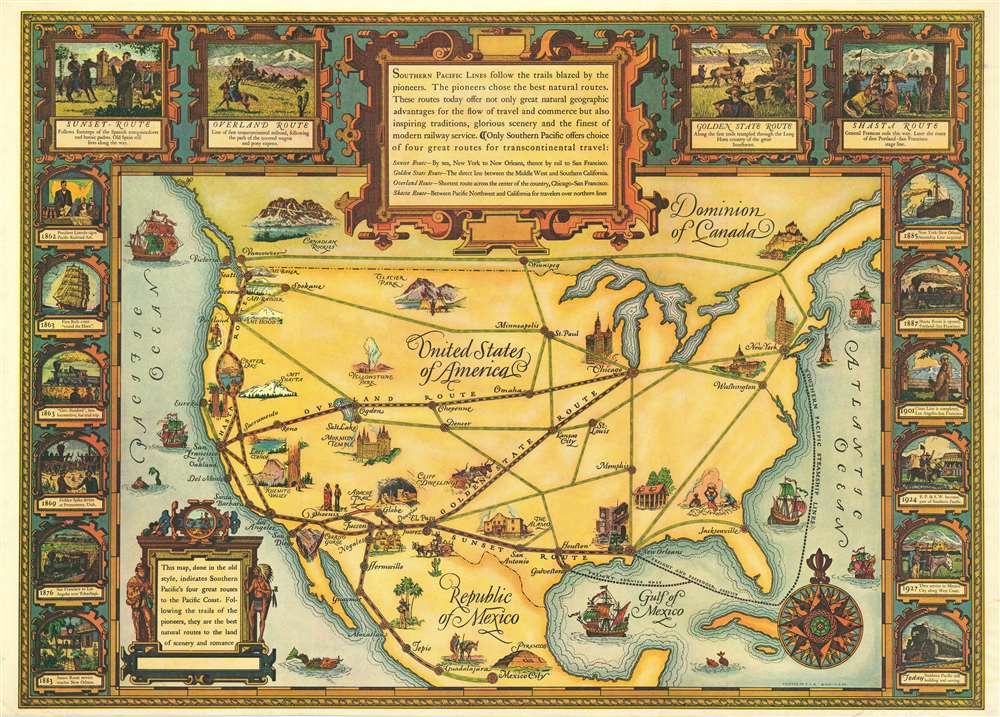
Southern Pacific Lines follow the trails blazed by the pioneers.
1928 (dated) 24 x 33 in (60.96 x 83.82 cm)
1928 (dated) 24 x 33 in (60.96 x 83.82 cm)
Description
This 1928 Southern Pacific Railroad pictorial map of the United States celebrates the Southern Pacific's four routes to the Pacific Coast and emphasizes the ease with which travelers can experience the grandeur of the United States. Southern Pacific also promotes the historical character of these four routes and employs vignettes along the top border to inform the viewer on each route's pioneer history. The railroad utilizes this history as a sales pitch, alongside pictorial vignettes of historic and natural wonders, such as the Cliff Dwellings at Mesa Verde, Yosemite Valley, Crater Lake, and Mt. Rainier. A dozen vignettes adorn the left and right borders, and continue the historic theme by illustrating the history of the first transcontinental railroad line (promoted here as Southern Pacific's 'Overland Route') and the expansion of Southern Pacific's rail network through the American Southwest and California.
Publication History and Census
This map was created for and published by the Southern Pacific Railroad in 1928. One example is catalogued in the OCLC and it is part of the collection at the Newberry Library in Chicago. This map also appears sporadically on the private market.Condition
Very good. Light wear along original fold lines. Close bottom margin.
References
Rumsey 8167.000. OCLC 930276174.