This item has been sold, but you can get on the Waitlist to be notified if another example becomes available, or purchase a digital scan.
1851 Tallis and Rapkin Map of the United States
UnitedStates-tallis-1851-2$175.00

Title
United States.
1851 (undated) 10 x 13.5 in (25.4 x 34.29 cm) 1 : 12500000
1851 (undated) 10 x 13.5 in (25.4 x 34.29 cm) 1 : 12500000
Description
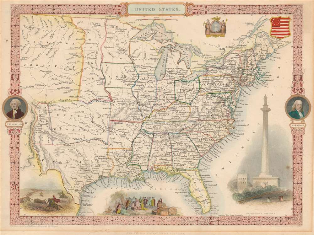
This exceptional 1851 John Tallis map of the United States features an incredible configuration of the geography of the western U.S. The map depicts the region from an unusually large Missouri Territory and New Mexico to the Atlantic and from the Canadian border to Mexico. The states in the eastern portion of the country are all illustrated as would be expected. All are labeled, and myriad cities and towns are identified. A handful of railroads are also included, although none are labeled. George Washington and Benjamin Franklin medallions decorate the right and left borders. Several decorative vignettes drawn by J. Marchant and engraved by J. Rogers adorn the work and depict a Native American Buffalo Hunt, William Penn's Treaty with the Indians, and the Washington Monument.
Other areas of interest includes a sprawling Nebraska Territory extending from the Kansas River to the Canadian Border but truncated on the west to the north of St. Pierre by the Missouri River. West of Nebraska, Tallis presents an extensive Missouri Territory extending off the edges of the map.
A Curious Configuration of Western Geography
The focus of this map is undoubtedly the Texas, New Mexico, and Western Territory political configuration, which when Rapkin drew this map remain unsettled. In the previous edition of this map, 1850, the area that is here New Mexico was part of the original Texas annexation. The Texas border presented here roughly follows the February 1850 proposal of Whig Senator Henry Clay, who recommended that, in exchange for federal assumption of its war debt, Texas surrender all lands north of the 32nd parallel and west of the 103rd Meridian. Those lands to the west of the 103rd Meridian would become New Mexico, those to the north of the 32nd parallel, would be an unorganized territory which Tallis has here dubbed 'Western Territory.' Henry Clay's proposal was not fully adapted, however, it did have an impact on the final compromise finally passed in September of 1850, presumably after this map was set to print.Other areas of interest includes a sprawling Nebraska Territory extending from the Kansas River to the Canadian Border but truncated on the west to the north of St. Pierre by the Missouri River. West of Nebraska, Tallis presents an extensive Missouri Territory extending off the edges of the map.
Where's California and the Pacific Coast?
Another anomalous element is Tallis' truncation of the United States at the Rio Grande. Curiously, though Tallis must have been aware of the United States annexation of Upper California (especially since the Gold Rush), as exhibited by his inclusion of the newly created New Mexico Territory, he does not extend the United States beyond the Rio Grande to include its western claims. Why Tallis made this decision is unclear though it may be a case of carto-advocacy in support of Mexico.Publication History
This map was drawn and engraved by John Rapkin and published by the John Tallis and Company in the 1851 edition of The Illustrated Atlas.CartographerS
John Tallis (November 7, 1817 - June 3, 1876) was an English map publisher and bookseller. Born in Stourbridge in Worcestershire, worked in his father's Birmingham agency from 1836 until 1842. Roughly in 1838, Tallis published a collection of London Street Views, and entered into a partnership with his brother Frederick Tallis from 1842 - 1849. Tallis and Company also published the Illustrated Atlas of the World in 1849. Also in 1849, Tallis traveled to New York City where he founded publishing agencies in six American cities. Upon returning from New York, Tallis paid his brother £10,000 for his share of the business, and operated from then on as John Tallis and Company until 1854. By 1853, John Tallis and Company had agencies in twenty-six cities in the United Kingdom, the United States, and Canada and employed over 500 people. By the end of 1853, Tallis had made the decision to share the burden of running such an extensive company and formed the London Printing and Publishing Company on February 24, 1854, becoming co-managing director with Ephraim Tipton Brain. After a series of setbacks, however, Tallis had to sell his estate and by 1861 was declared bankrupt. He was kept afloat by the kindness of friends and former employees, but none of his 'various ambitious projects' ever worked out for the rest of his life. Tallis married Jane Ball on December 6, 1836 in Birmingham, with whom he lived until her death in 1862. Tallis remarried on June 27, 1863 to Mary Stephens, with whom he had two children. More by this mapmaker...
John Rapkin (July 18, 1813 - June 20, 1899) was an English mapmaker and engraver. Born in Southwark, Rapkin was the son of George Rapkin, a shoemaker, and his wife Elizabeth Harfy. Rapkin and his brother Richard both became engravers and his other brother, William Harfy Rapkin, became a copperplate printer. Rapkin produced works for James Wyld and John Tallis, including The United States and the relative position of Oregon and Texas for Wyld around 1845, and a series of eighty maps for Tallis that became 'Tallis's illustrated atlas, and modern history of the world' in 1851. Rapkin married Frances Wilmot Rudell on January 4, 1837, with whom he had at least eight children, some of whom became engravers, including his sons John Benjamin Rapkin (1837 - 1914), Alfred Thomas Rapkin (1841 - 1905), Joseph Clarke Rapkin (1846? - 1912), and Frederick William Rapkin (1859 - 1945). Rapkin operated under the imprint 'John Rapkin and Sons from 1867 until 1883, and was operating as 'John Rapkin and Sons' by 1887. Rapkin died in 1899 at the age of 85 soon after the death of his wife of over sixty years. Learn More...
Source
Tallis, J. and F., The Illustrated Atlas, And Modern History Of The World Geographical, Political, Commercial & Statistical, 1851.
Condition
Good. Exhibits some matte burn in margins. Blank on verso.
References
Rumsey 0466.071. Phillips (Atlases) 804-70.