This item has been sold, but you can get on the Waitlist to be notified if another example becomes available, or purchase a digital scan.
1871 Walling and Gray Map of the United States
UnitedStates-walling-1871$100.00

Title
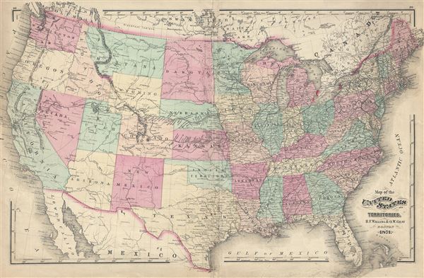
Map of the United States and Territories.
1871 (dated) 16 x 25 in (40.64 x 63.5 cm) 1 : 7500000
1871 (dated) 16 x 25 in (40.64 x 63.5 cm) 1 : 7500000
Description
An attractive 1871 map of the United States issued by Henry Walling and Ormando Gray. This map covers the entire United States from Atlantic to Pacific, Canada to Mexico. It is color coded to identify all states. Important transnational rail routes are noted as are major cities and military fortifications. The Unites States is today much as presented here with the exception of Dakota, which had not yet split into northern and southern departments. Published as plate nos. 29 and 29 in Walling and Gray's 1871 Atlas of Massachusetts.
CartographerS
Henry Francis Walling (June 11, 1825 - April 8, 1889) was an American civil engineer, cartographer, surveyor, and map publisher active from the middle to late 19th century. Walling was born in Providence, Rhode Island. He studied/worked at the Providence Athenaeum before discovering a talent for mathematics and surveying. Walling took a position with Samuel Barrett Cushing (1846 - 1888), a Providence-based civil engineer with whom he issued in 1846 a revision of James Steven's Topographical Map of the State of Rhode-Island. Walling established himself independently around 1850 and immediately began preparing a series of town plans focusing on Bristol County, near Providence. Buoyed by widespread interest in his plans, Walling expanded his operations to Massachusetts, where, by 1857, he had produced no less than 50 town plans. Apparently, Walling's business model involved a contract with town officials to produce a certain number of maps, after which he acquired the right to print and sell additional copies on his own account. This work eventually led to Walling's appointment as Massachusetts "Superintendent of the State Map", a designation that began appearing on his maps around 1855. While Walling's work focused heavily on city and county maps, he successfully published three scarce state maps: Maine, Vermont, and Rhode Island. In 1856, Walling relocated his headquarters to New York City, where he had better access to quality lithographers. The Civil War (1861 - 1865) proved difficult for Walling, and diminished sales may have forced him into a partnership with Ormando W. Gray, with whom he published numerous state, county, and national atlases in the 1860s and 1870s. Around 1880, Walling took a post with the U.S. Coast Survey, with whom he worked on various charts until requesting a transfer in 1883 to the newly formed U.S. Geological Survey. Walling remained with the Geological Survey until his untimely death of a heart attack in April 1889. More by this mapmaker...
Ormando Wyllis Gray (March 3, 1829 – July 6, 1912) was a mid to late 19th century map publisher with offices in New York City, Philadelphia, PA, and Danielsonville, Connecticut. Born in Townshend, Vermont, he attended Norwich College where he studied civil engineering and became a civil engineer and surveyor. Gray's first commercial atlas was an 1869 survey of Windhamd and Toland counties, Connecticut. His most important work seems to have been done in conjunction with other, more prominent map publishers, including Henry Walling and G.W. and C.B. Colton. Gray is best known for his state and county atlases, though did, with his sons, also independently issue at least two national atlases in the late 1870s. He retired from the map publishing business in 1890. He died at home in Bernardston, Massachusetts. He married Roxcena L. Arnold in 1851, with whom he had three daughters and one son. Learn More...
Source
Walling, H. F., and Gray, O. W., Official topographical atlas of Massachusetts, from astronomical, trigonometrical and various local surveys, (Stedman, Brown & Lyon) 1871.
Condition
Good. Backed with archival tissue for stability. Light soiling and minor repair tears restricted to lower margins. Centerfold wear.
References
Rumsey 1154.003.