1861 New York Herald Map of the United States during the American Civil War
UnitedStatesBlackWhite-nyherald-1861$750.00

Title
The United States in Black and White. / Major General Butler's Expedition.
1861 (dated) 22.25 x 15.5 in (56.515 x 39.37 cm)
1861 (dated) 22.25 x 15.5 in (56.515 x 39.37 cm)
Description
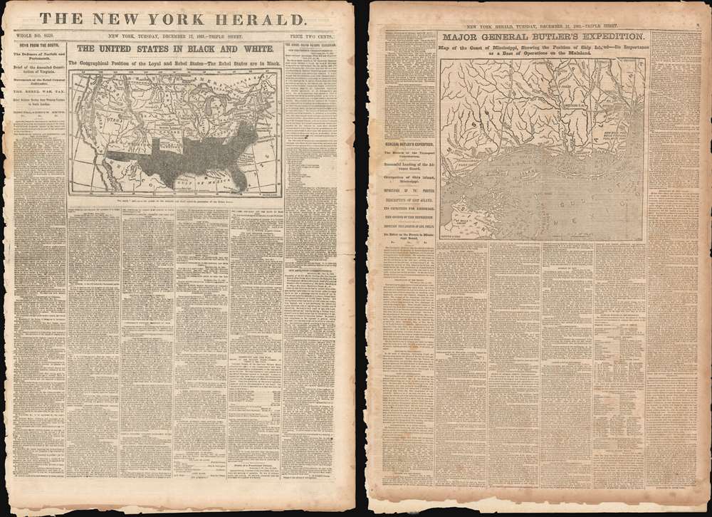
Presented here is the full December 17, 1861 edition of The New York Herald published eight months into the American Civil War. This edition features two maps: a front-page map of the United States that highlighting the Confederacy and a map of the Gulf Coast of Mississippi detailing Major General Benjamin Butler's landing on Ship Island. Ship Island, located twelve miles off the coast of Mississippi in the Gulf of Mexico, provided the Union Army with a base of operations in the Gulf. It also allowed the Union some flexibility, in that they could theoretically launch attacks against Texas or New Orleans from Ship Island, which caused the Confederacy significant anxiety.
At the beginning of the Civil War, support for the Confederacy ran high in the southern parts of the New Mexico Territory. Local concerns drove this sentiment, including a belief that the war would lead to an insufficient number of Federal troops to protect the citizens from the Apache, while others simply felt neglected by the government in Washington. Also, the Butterfield Overland Mail Route (an overland mail and stagecoach route from Memphis and St. Louis to San Francisco) was closed in 1861, depriving the people of Arizona of their connection to California and the East Coast.
All of these factors led to the people of the southern New Mexico Territory, or the Arizona Territory, to formally call for secession, and a convention adopted a secession ordinance on March 16, 1861, with a subsequent ordinance ratified on March 28, establishing the provisional territorial government of the Confederate 'Territory of Arizona'. The Confederate Arizona Territory was officially proclaimed on August 1, 1861 following Lieutenant-Colonel J. R. Baylor's victory over Union forces in the First Battle of Mesilla, and the territory was officially recognized by the government of the Confederacy on February 14, 1862. However, by July 1862, Union forces from California, known as the 'California Column' were marching on the territorial capital of Mesilla. Sent to protect California from a possible Confederate incursion, the 'California Column' drove Confederate forces out of the city, allowing them to retreat to Franklin, Texas. The territorial government fled as well and spent the rest of the war in 'exile'. First, they retreated to Franklin, then, after Confederate forces abandoned Franklin and all of West Texas, to San Antonio, where the 'government-in-exile' would spend the rest of the war. Confederate units from Arizona would fight for the rest of the war, and the delegate from Arizona attended both the First and Second Confederate Congresses.
Major General Benjamin Butler, Ship Island, and the American Civil War
Butler's fascination with Ship Island began in September 1861, when he was granted authorization to 'raise, organize, arm, uniform, and equip a volunteer force for the war'. His original planned called for an invasion of the Virginia coast. But, after receiving word that his intended target area had been evacuated by the Confederates, Butler changed his plans attacked the Gulf Coast, with an eye on taking New Orleans or establishing a foothold in Texas. In the end, he chose to occupy Ship Island, which had been garrisoned by Union marines and northern sailors since September. His initial plan included two infantry regiments and a light artillery battery, which left Boston Harbor aboard the SS Constitution on November 21, 1861. They landed on Ship Island on December 4, beginning an occupation that would last the rest of the war. Many different units passed through the island, with 15,000 men staging there in April 1862 in preparation for the assault on New Orleans. Many soldiers only spent a few days on the island, others as much as a few weeks. The longest tenured were the African-American 2nd Louisiana Native Guards, which arrived on January 12, 1863 and stayed through the end of the war. Ship Island also served as a Union prison, receiving its first detainees in June 1862. Civilians and Union soldiers convicted of serious crimes were imprisoned there. In October 1864, the first Confederate prisoners arrived on the island and it became a major holding area for prisoners of war, at one point holding more than 3000 detainees.A Map of the Union and the Confederacy
While the map on the front page, at its base, is a map of the Union and the Confederacy, some interesting historical and geographical events are illustrated as well. The most obvious is Confederate Arizona, but another curiosity is the long panhandle attached to the Nebraska Territory.Confederate Arizona
Confederate Arizona was a territory claimed by the Confederate States of America from 1861 until 1865. The idea for an Arizona Territory appears as early as 1856, when the government of the Territory of New Mexico began to express concerns about being able to effectively govern the southern part of the territory, as it was separated from Santa Fe by the Jornada del Muerto, a particularly unforgiving stretch of desert. The New Mexico territorial legislature acted on these concerns in February 1858, approving a resolution in favor of creating an Arizona Territory, with a north-south border to be defined along the 32nd meridian (from Washington). Impatiently waiting for Congress to approve the creation of the new territory, 31 delegates met at a convention in Tucson in April 1860 and drafted a constitution for the 'Territory of Arizona', which was to be organized out of the New Mexico Territory below 34th parallel. The convention even elected a territorial governor and a delegate to Congress. Congress, however, was reluctant to act. Anti-slavery Representatives knew that the proposed territory was located below the line of demarcation set forth by the Missouri Compromise for the creation of new slave and free states, and they were not inclined to create yet another slave state. Thus, Congress never ratified the proceedings of the Tucson convention, and the Provisional Territory was never considered a legal entity.At the beginning of the Civil War, support for the Confederacy ran high in the southern parts of the New Mexico Territory. Local concerns drove this sentiment, including a belief that the war would lead to an insufficient number of Federal troops to protect the citizens from the Apache, while others simply felt neglected by the government in Washington. Also, the Butterfield Overland Mail Route (an overland mail and stagecoach route from Memphis and St. Louis to San Francisco) was closed in 1861, depriving the people of Arizona of their connection to California and the East Coast.
All of these factors led to the people of the southern New Mexico Territory, or the Arizona Territory, to formally call for secession, and a convention adopted a secession ordinance on March 16, 1861, with a subsequent ordinance ratified on March 28, establishing the provisional territorial government of the Confederate 'Territory of Arizona'. The Confederate Arizona Territory was officially proclaimed on August 1, 1861 following Lieutenant-Colonel J. R. Baylor's victory over Union forces in the First Battle of Mesilla, and the territory was officially recognized by the government of the Confederacy on February 14, 1862. However, by July 1862, Union forces from California, known as the 'California Column' were marching on the territorial capital of Mesilla. Sent to protect California from a possible Confederate incursion, the 'California Column' drove Confederate forces out of the city, allowing them to retreat to Franklin, Texas. The territorial government fled as well and spent the rest of the war in 'exile'. First, they retreated to Franklin, then, after Confederate forces abandoned Franklin and all of West Texas, to San Antonio, where the 'government-in-exile' would spend the rest of the war. Confederate units from Arizona would fight for the rest of the war, and the delegate from Arizona attended both the First and Second Confederate Congresses.
Publication History
These maps were created for and published in the Tuesday, December 17, 1861 edition of The New York Herald.Source
New York Herald. Tuesday, December 17, 1861.
The New York Herald (1835 - 1924) was a daily newspaper in New York City first published on May 6, 1835. It was owned by James Gordon Bennett, Sr and was the most profitable and popular daily newspaper in the United States by 1845. By 1861, the New York Herald had a daily circulation of 84,000 copies. The paper staunchly supported the Democratic Party during the American Civil War. James Gordon Bennett, Jr., the elder Bennett's son, took over the paper in 1866. During his time in charge, the Herald financed Henry Morton Stanley's expedition to Africa to find David Livingstone, as well as Stanley's Trans-Africa expedition. The Herald also financed George W. DeLong's failed expedition to the Arctic. After Bennett Jr. died in 1924, the Herald was sold to the New York Tribune, which formed the New York Herald Tribune.
Condition
Good. Full newspaper. Exhibits tattered edges.