This item has been sold, but you can get on the Waitlist to be notified if another example becomes available, or purchase a digital scan.
1941 Rand McNally Map of United States military bases and mineral resources
UnitedStatesDefenseMap-randmcnally-1941$125.00

Title
Rand McNally Defense Map of the United States.
1941 (undated) 16.75 x 26.5 in (42.545 x 67.31 cm) 1 : 7280000
1941 (undated) 16.75 x 26.5 in (42.545 x 67.31 cm) 1 : 7280000
Description
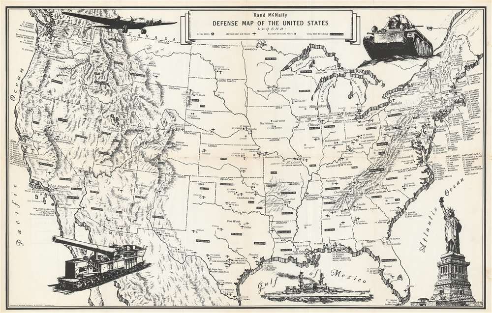
This is a c. 1941 Rand McNally map of United States military installations and strategic mineral deposits. The map depicts the continental United States from the Pacific Ocean to the Atlantic Ocean and from Canada to Mexico. U.S. army and navy bases are identified throughout the country, with different symbols used to mark specific types of installations. Naval bases are marked by and anchor inscribed in a circle, while army and navy air fields are highlighted by a silhouette of an airplane. It is important to note that at this point in American history, there was no independent U.S. Air Force. Prior to 1947, when the U.S. Air Force was established, land-based military aircraft had been the responsibility of the U.S. Army Air Forces, while sea-based operations were conducted by the U.S. Navy. The U.S. Marine Corps also had its own aviation division meant for close air support of Marine Corps operations. Other army or navy posts are marked by a black square. Strategic resources, such as oil (petroleum), gold, tin, mercury, coal, and iron (among others) are scattered throughout the map and are noted by while block letters inside in a black box. Little other detail is included, except state capitals that do not host a military base are labeled. Five pictorial vignettes adorn the map. Beginning in the upper left corner and moving clockwise an airplane, a tank, the Statue of Liberty, a battleship, and a rail gun are illustrated.
Publication History and Census
This map was created and published by Rand McNally c. 1941. This map is present in institutional collections at the University of Illinois Urbana-Champaign, Texas A and M University, the Buffalo and Erie County Public Library, and the Denver Public Library.Cartographer
Rand, McNally and Co. (fl. 1856 - present) is an American publisher of maps, atlases and globes. The company was founded in 1856 when William H. Rand, a native of Quincy, Massachusetts, opened a print shop in Chicago. Rand hired the recent Irish immigrant Andrew McNally to assist in the shop giving him a wage of 9 USD per week. The duo landed several important contracts, including the Tribune's (later renamed the Chicago Tribune) printing operation. In 1872, Rand McNally produced its first map, a railroad guide, using a new cost effective printing technique known as wax process engraving. As Chicago developed as a railway hub, the Rand firm, now incorporated as Rand McNally, began producing a wide array of railroad maps and guides. Over time, the firm expanded into atlases, globes, educational material, and general literature. By embracing the wax engraving process, Rand McNally was able to dominate the map and atlas market, pushing more traditional American lithographic publishers like Colton, Johnson, and Mitchell out of business. Eventually Rand McNally opened an annex office in New York City headed by Caleb S. Hammond, whose name is today synonymous with maps and atlases, and who later started his own map company, C. S. Hammond & Co. Both firms remain in business. More by this mapmaker...
Condition
Very good. Even overall toning. Wear along original fold lines. Verso repairs to fold separations and at fold intersections. Blank on verso.
References
OCLC 13775448.