1801 Tardieu Map of the Northeastern United States w/Military Tracts
UnitedStatesNE-tardieu-1801$600.00

Title
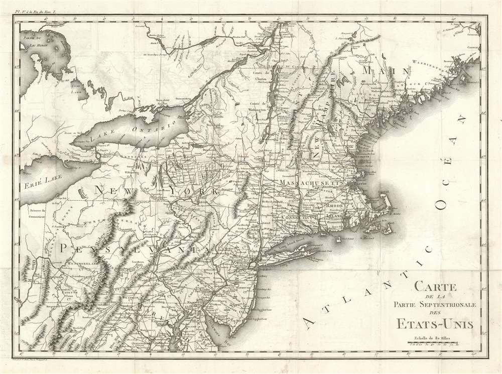
Carte De La Partie Septentrionale Des Etats-Unis.
1801 (undated) 14 x 20 in (35.56 x 50.8 cm) 1 : 2400000
1801 (undated) 14 x 20 in (35.56 x 50.8 cm) 1 : 2400000
Description
An important and highly detailed 1801 map of the northeastern United States by Pierre Francis Tardieu. The map was issued to a accompany Michel Guillaume de Crevecoeur's Le Voyage dans la Haute Pennsylvania et dans l'État de New-York, one of the most important post-Revolutionary War books about life and economy in the fledgling United States. Coverage extends from Maine to the District of Columbia and west as far as Ohio and the Connecticut Reserve, including modern-day New England, New York, New Jersey, Pennsylvania, and parts of Maryland, Delaware, and West Virginia. The map is notable for its exceptional detail, naming towns and roads, as well as surveyed military tracts intended to compensate Revolutionary War soldiers for their war effort.
Central New York Military Tract
The Military Tract of Central New York, also called the New Military Tract, consisted of nearly two million acres (8,100 km2) of bounty land set aside in Central New York to compensate New York's soldiers for their participation in the Revolutionary War. Soldiers were guaranteed 500 acers each from the newly laid down tracks. These lands were carefully surveyed out in the Finger Lakes region of New York - north of Oswego and west of Cooperstown, covering the modern-day counties of Cayuga, Cortland, Onondaga, and Seneca, and parts of Oswego, Tompkins, Schuyler and Wayne. Apparently at the whim of Robert Harpur, a clerk in the office of New York's Surveyor General, the new townships were named after figures from classical antiquity, including Greek and Roman statesmen and the Carthaginian general Hannibal.Connecticut Western Reserve
At the far western section of the map, on the shores of Lake Erie, the Connecticut Western Reserve is noted. This section of northeastern Ohio, rarely seen on maps, was ceded to Connecticut by King Charles II in exchange for Westmoreland County, Pennsylvania, following the Yankee-Pennamite Wars. Connecticut gave up its claims to the Western Reserve in 1800, when they were sold to the Connecticut Land Company, a group of speculators based in Suffield, Connecticut. Surveyors were sent out, under Moses Cleveland, to divide the reserve into township and found the city of Cleveland, first known as 'New Salem.'Publication History and Census
This map was engraved in Paris by Pierre Francis Tardieu for inclusion in Michel Guillaume de Crevecoeur's Le Voyage dans la Haute Pennsylvania et dans l'État de New-York. Despite being his longest and most comprehensive work on the Americas, it never attained the popularity of the 1784 Letters d'un Cultivateur Américain. There were multiple editions of the book, but only one of the map. Today this map is uncommon on the market and its significance often underappreciated. The OCLC identifies 3 examples of the separate maps.Cartographer
Pierre François Tardieu (1711 - 1771) was a French engraver and mapmaker active in Paris during the middle part of the 18th century and a member of the large and prolific Tardieu family. Several members of the family established themselves as engravers, and, for over 200 years, the family produced works. Pierre Francois Tardieu was born around 1711 in Paris, son of Jean Tardieu. His uncle, Nicolas-Henry Tardieu, taught him the art of engraving. Pierre was a general engraver whose work was not limited to maps but also included historical and genre works. Many of his maps are extremely significant and include some of the finest French productions of the period. Tardieu had his office at Rue de al Corderie, Paris. Tardieu was married to Marie-Anne Rousselet (1733-1826), whose family included the engraver Gilles Rousselet and the sculptor Jean Rousselet. It is highly likely that Pierre Francois Tardieu was succeeded by Pierre Antoine Francois Tardieu (1757 - 1822), who is also possibly his son, as the latter continued to engrave under the P. F. Tardieu imprint well after the former's death. More by this mapmaker...
Source
Crevecoeur, Michel Guillaume St. Jean de, Le Voyage dans la Haute Pennsylvania et dans l'État de New-York, (Paris) 1801.
Condition
Very good. Some offsetting. Wear on original fold lines.
References
OCLC. 58915829.