This item has been sold, but you can get on the Waitlist to be notified if another example becomes available, or purchase a digital scan.
1804 Bradley / Morse Map of the Northern United States
UnitedStatesNorthern-bradley-1804$350.00

Title
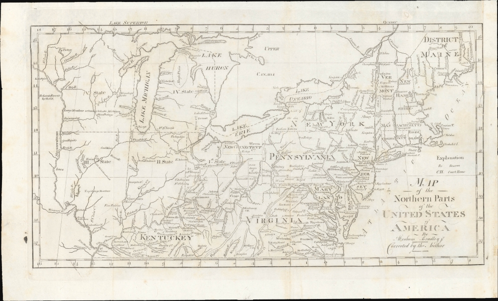
Map of the Northern Parts of the United States of America.
1804 (undated) 10 x 17 in (25.4 x 43.18 cm) 1 : 5600000
1804 (undated) 10 x 17 in (25.4 x 43.18 cm) 1 : 5600000
Description
This is a significant 1802 map of the northern parts of the United States illustrating postal routes and the five Jeffersonian states proposed by the Ordinance of 1789. The present example is the Jedidiah Morse issue of the northern part of Abraham Bradley's 1797 postal map of the United States - one of the most important maps in American history. It is one of the first American maps to extend west to the Mississippi River, and one of the first to address early colonization of the lands west of Pennsylvania, including Ohio.
This map is especially significant for its portrayal of territory west of Pennsylvania, where it illustrates the proposed Jeffersonian states of the Northwest Ordinance (1789). Although none of the new territories and states are named, just numbered, the preliminary borders of Ohio, Indiana, Illinois, Michigan, and Wisconsin are evident. Information on terrain, topography, and other features is recorded throughout. Early trade agreements and land settlement schemes are also noted. Among these are New Connecticut, also known as the Connecticut Western Reserve.
A line extending westwards through Ohio and then south to the Ohio River is labeled 'Gen. Wayne's Treaty 1795' and below simply as 'boundary line.' This was the result of the Treaty of Greenville, signed in 1795 by Gen. Anthony Wayne and representatives of several Native American groups. It ended the Northwest Indian War and was meant to set a line limiting white settlements. But this line was soon breached, Wayne died shortly afterwards, and tensions began to build again. Native American leaders in the Northwest Territory who had mistrusted the U.S., including Tecumseh, gained support, resulting in further violence, especially Tecumseh's War.
A Closer Look
This map is a treasure trove of early American geography that rewards close study. Centered on Ohio's Connecticut Western Reserve, it extends from the Mississippi River to the Atlantic, and From Lake Huron to Kentucky. The eastern seaboard includes lines depicting the nascent U.S. postal system, extending from eastern cities all the way to Kaskaskia on the Mississippi River, an important settlement that was eclipsed by nearby St. Louis soon afterwards. Washington, D.C. is prominent, having only been formally incorporated three years prior with the District of Columbia Organic Act; here it includes Alexandria and Arlington County west of the Potomac, which were retroceded to Virginia in 1846.This map is especially significant for its portrayal of territory west of Pennsylvania, where it illustrates the proposed Jeffersonian states of the Northwest Ordinance (1789). Although none of the new territories and states are named, just numbered, the preliminary borders of Ohio, Indiana, Illinois, Michigan, and Wisconsin are evident. Information on terrain, topography, and other features is recorded throughout. Early trade agreements and land settlement schemes are also noted. Among these are New Connecticut, also known as the Connecticut Western Reserve.
The 'Western Reserve'
This section of northeastern Ohio, rarely seen on maps, was ceded to Connecticut by King Charles II in exchange for Westmoreland County, Pennsylvania, following the Yankee-Pennamite Wars (1769 - 1784). Connecticut gave up its claims to the Western Reserve in 1800. The claims were sold to the Connecticut Land Company, a group of speculators based in Suffield, Connecticut. Surveyors were sent out, under Moses Cleveland, to divide the reserve into townships and found the city of Cleveland, here identified as 'New Salem'. The name was then changed to 'New Connecticut' as seen here. Some places and institutions in Northeast Ohio still retain the name Western Reserve, such as Case Western Reserve University and the Western Reserve Historical Society.The Ohio Company
Further south, the lands of the Ohio Company embrace the northern shore of the Ohio River between Marietta and the Grand Sandy River. The Ohio Company was a land speculation company based in Virginia that received a royal charter in 1749. Settlement did ensue but was not as profitable as might have been imagined. After the Northwest Ordinance, the Ohio Company lands became a district of Ohio. The Seven Ranges Townships, reflective of early survey efforts, appear just to the northeast.Additional Reserves and Boundary Lines
The map further identifies various reserves, many of which would soon become the sites of major cities. These include Chicago, Vincennes, Fort Wayne, Toledo, and Cincinnati, here identified as, 'Cincinnatus.' American Indian lands are also noted, particularly the Six Nations (Iroquois) on the eastern shores of Lake Erie, and the Chippewa near New Madrid.A line extending westwards through Ohio and then south to the Ohio River is labeled 'Gen. Wayne's Treaty 1795' and below simply as 'boundary line.' This was the result of the Treaty of Greenville, signed in 1795 by Gen. Anthony Wayne and representatives of several Native American groups. It ended the Northwest Indian War and was meant to set a line limiting white settlements. But this line was soon breached, Wayne died shortly afterwards, and tensions began to build again. Native American leaders in the Northwest Territory who had mistrusted the U.S., including Tecumseh, gained support, resulting in further violence, especially Tecumseh's War.
Publication History and Census
This map was drawn by Abraham Bradley, engraved by Jedediah Morse for the second (1804) edition of Morse's American Gazetteer, printed by Samuel Etheridge, and published by Thomas and Andrews. It exists in at least 2 states; in the first state, the title is slightly different, 'Northern Part' vs. the present 2nd state, which reads, 'Northern Parts.' The two states are otherwise very similar.CartographerS
Abraham Bradley, Jr. (1767 - 1838) was an American lawyer, judge, and cartographer who served as assistant postmaster general for thirty years. Bradley was responsible for moving the federal post office from Philadelphia to Washington, D.C. and even hosted the national post office in his home for a period. He was employed under five different U.S. postmasters general and drew detailed and innovative maps of postal routes. Bradley, after having established his private law practice in 1788, briefly served as a county judge. There he became acquainted with Timothy Pickering, who was appointed by President Washington as postmaster general in 1791. Bradley served as his clerk, and began compiling information for a complete postal service map. Bradley's extensive knowledge of the department and the routes made him indispensable when Pickering was succeeded in 1795. Bradley is regarded as an influential figure in the early history of the Post Office. His postal routes and schedules were rigidly enforced for thirty years and gave the department a 'rapid and reliable engine for delivering information across vast distances'. More by this mapmaker...
Jedidiah Morse (August 23, 1761 – June 9, 1826) was an American geographer and minister active in Connecticut during the late 18th and early 19th centuries. Morse wan born in Woodstock, Connecticut and studied at Yale University, earning a M. A. in 1786. He advocated for better education for young women and founded a school to this end in New Haven in 1783. Morse was active in religious circles and often railed against the 'assaults of Unitarianism.' Nonetheless, it was as an advocate for women's education that Morse contributed the most to cartography. Recognizing a need for better textbooks, he published a series of geographies including Geography Made Easy (1784), American Geography (1789), and the Universal Geography of the United States (1797). His work with geographical textbooks earned him the informal title 'Father of American Geography.' He married Elizabeth Ann Finley Breese sometime after 1789, when he became a pastor in Charlestown, Boston, with whom he had several children. His eldest son, Samuel Finley Breese Morse (April 27, 1791 – April 2, 1872), was a noted painter and telegraphy pioneer (also a co-developer of Morse code). Some of his other children were Sidney Edwards Morse (February 7, 1794 - December 24, 1871), a noted geographer and inventor, and Richard Cary Morse (1795 - 1868), who helped his father with his geographical work and founded the New York Observer with his brother Sidney. Learn More...
Source
Morse, J., American Gazetteer... (Charlestown, Mass.: S. Etheridge) 1804.
Condition
Very good. Light foxing and soiling. Margin repair upper right, as well as right border damage around 45°N.
References
New York Public Library, Map Div. 01-5257. OCLC 35064994. Karpinski, L. C., Bibliography of the Printed Maps of Michigan, 1804-1880, #CXIX. Phillips (America) p. 874.