This item has been sold, but you can get on the Waitlist to be notified if another example becomes available, or purchase a digital scan.
1939 Earl Purdy PWA Pictorial Wall Map of the United States
UnitedStatesPBA-purdy-1939$900.00


Title
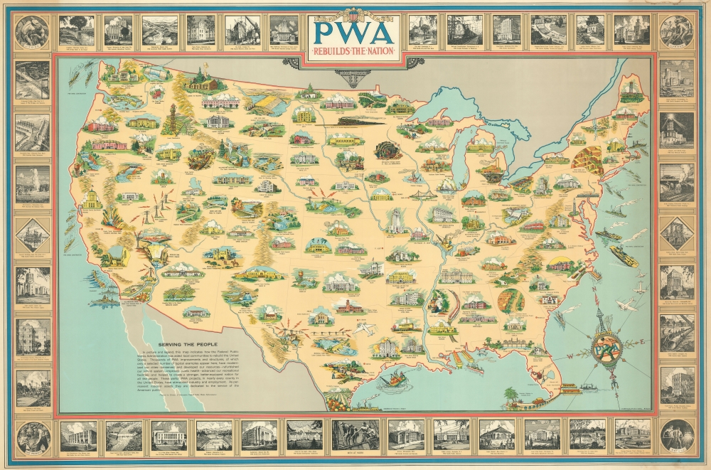
PWA Rebuilds the Nation.
1939 (dated) 34.5 x 52.5 in (87.63 x 133.35 cm) 1 : 4320000
1939 (dated) 34.5 x 52.5 in (87.63 x 133.35 cm) 1 : 4320000
Description
An impressive 1939 large-format Earl Purdy pictorial wall map of the United States made to celebrate the accomplishments of the New Deal Public Works Administration (PWA) and bolster F. D. Roosevelt's third term reelection campaign. Roosevelt's PWA was one of his most popular New Deal initiatives and its universal acclaim is celebrated here. The map illustrates the PWA's many accomplishments, rebuilding the nation's transportation infrastructure, education system, energy grid, and more.
The Map Speaks
A textual note on the map tells the story:SERVING THE PEOPLE. In picture and legend, this map indicates how the Federal Public Works Administration has aided local communities to rebuild the United States. Thousands of PWA improvements and structures, of which only a selected number of typical examples appear here, have modernized our cities - conserved and developed our resources - refurbished our school system - improved public health - advanced our recreational facilities - and helped to create a stronger, better-equipped nation for all the people. These useful PWA projects, in nearly every county in the United States, have stimulated industry and employment. As permanent national assets they are dedicated to the service of the American public.
PWA: Federal Public Works Administration
The Public Works Administration was one of Roosevelt's signature New Deal initiatives. Founded in 1933, the PWA, as it is commonly known, was a large-scale public works construction agency in the United States headed by Secretary of the Interior. Between 1933 and 1939, the PWA funded private contractors and artist to complete more than 34,000 projections, ranging from airports, large electricity-generating dams, major warships for the Navy, and bridges, as well as 70% of the new schools and one-third of the hospitals built during its period of activity. Although it is arguable that the PWA was a major success, it did drastically upgrade the national infrastructure and pump billions of dollars into the economy. It was therefore a broadly popular program.Publication History and Census
This map was illustrated by Earl Purdy and published by the Division of Information of the PWA. The map is extremely scarce on the market but held by several institutions. It is well represented in the OCLC, but further research suggests that most records are duplicate digital holdings.Cartographer
Earl Purdy (June 6, 1892 - April 22, 1971) was an American architect and artist active throughout the 20th century. Purdy as born in Cohoes, New York. He lived most of his lie in New Rochelle, New York. He served in the United States Navy during World War I before taking a degree in architecture at Colgate, then Cornell, the Columbia University. Graduating he worked with various architecture firms as a designer and draftsman. He was awarded the French Government Society des Archetects Première Medaille for excellence in design. As an artist, he completed work during the New Deal for the PWA, including a 1939 large-format pictorial map of the United States. He also designed the United Nations 'Geneva" stamp. His architectural work can be seen at the National Cemetery in Florence, the Veterans Hospital in Hawaii, Rye Playland, and Ringling House in Sarasota Florida. He was also a member of the American Institute of Architects, the American Watercolor Society, the University Men's Glee Club, and the University Club. He artworks includes a series of 34 caricatures hanging in the lounge of the Hotel Washington, Washington D.C., across the street from the White House. More by this mapmaker...
Condition
Very good. A few minor edge reinforcements and repairs on verso. Slight water toning upper right border.
References
OCLC 7195102. Rumsey 3975.000. Boston Public Library, G3701.A5 1939 .U5. Cornell University, Persuasive Maps: PJ Mode Collection, 1276.01.