This item has been sold, but you can get on the Waitlist to be notified if another example becomes available, or purchase a digital scan.
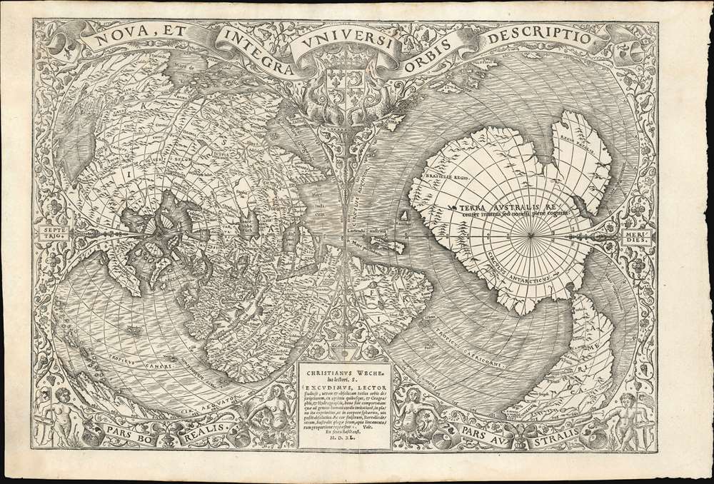
1540 Oronce Fine Double Cordiform Map of the World on Polar Projection
UniversiOrbis-fine-1540$32,500.00

Title
Nova, et Integra Universi Orbis Descriptio.
1540 (dated) 12.75 x 18.5 in (32.385 x 46.99 cm)
1540 (dated) 12.75 x 18.5 in (32.385 x 46.99 cm)
Description
This the rare and influential 1531 Oronce Fine map of the world, portrayed using a double cordiform polar projection. This intricate woodcut map was both influential and - especially compared to other printed maps of its era - remarkably reflective of state-of-the-art cartographic detail. Rodney Shirley proclaimed it 'a rendering considerably in advance of any others printed earlier.' Many areas of significant interest are addressed in detail for the first time. The peninsular shape of Florida is clearly presented for the first time, and both Pineda and Cortez' mapping of the Gulf of Mexico are recorded here. This is the first printed map to refer to Magellan's voyage, naming a 'Mare Magellanicum' west of South America. The map breaks from Martin Waldseemüller's convention of presenting North America as separate from Asia: Fine's map incontrovertibly presents Labrador, Florida and the Gulf Coast as part of the Asian mainland; South America itself is depicted as taking the place of the Ptolemaic Great Promontory, or 'Dragon's Tail' that appeared on earlier maps like the 1507 Waldseemüller and the 1490 Martellus. Although including (but not naming) Magellan's strait, the map fails to account for the size of the ocean that circumnavigator revealed (despite naming that ocean - Mare Magellanicum.)
Other features of the New World appear. In the extreme lower left of the map, part of the Caribbean appears. Jamaica, Hispaniola and Dominica are named. Puerto Rico is shown with its early name 'Borique.' The northern coast of South America appears, and even part of the Pacific Ocean is visible beyond what is now the isthmus of Panama. In North America, the northeastern portion is named 'Baccalar', a reference to the Regio Baccalareum, or 'Land of Cod.' (Portuguese and Basque sailors had long been feeding Europe by fishing the waters of maritime Canada.)
Mapping the Yucatan as an island would have been significant for Fine. In line with his assumption that the recently conquered Aztec Empire was China / Cathay, then he needed a large island to be Japan, which Cortés provided in his insular mapping of the Yucatan (Pucatans).
When Fine drew this map, Terra Australis had long been assumed to exist, based upon the writings of Aristotle, despite no discovery. Aristotle argued that the globe was a place of balances and thus geographers presumed the bulk of Eurasia must be counterbalanced by a similar landmass in the Southern Hemisphere, just as, they argued, the Americas counterbalanced Africa and Europe.
Here Fine describes it as 'recenter inventa, sed nondu[m] plene cognita ' (trans: 'recently discovered, but not fully explored'). By 'discovered' Fine is referring to the circumnavigation of Ferdinand Magellan (1519 - 1522) and the discovery of Tierra del Fuego and Strait of Magellan - visible here at the bottom right. Until the circumnavigation of Sir Francis Drake (1577 - 1580), it was widely believed that Tierra del Fuego, the lands sighted to the south of the Strait of Magellan, were in fact attached to the supposed 'Terra Australis.' Many explorers from the 16th to the 18th centuries sought the Great Southern continent, including Quiros, Drake, and Cook, but Antarctica itself was not truly discovered until Edward Bransfield and William Smith sighted the Antarctic Peninsula in 1820.
Fine's iteration of Terra Australis is significant and had a long-lasting influence on subsequent cartography. Note the form of the continent, with great bays, rivers and projections. It leads one to wonder - where did it come from? Close study reveals a strict adherence to Artistotle's principals of balance. Terre Australis is narrow and close to the equator in Africa and South America, where known lands push far into the south seas. The continent is correspondingly enormous where it must counter the emptiness of the Indian Ocean. The great bite, accommodates the Indian subcontinent and Southeast Asia, but also addresses the need to balance South America.
The Projection
Fine used a mathematical projection model to present the curvatures of the Earth on a complex double-cordiform hemispheric projection. The two heart-shaped cordum face one another, with the tip of the heart's 'V' representing the North Pole (left, or northern cordum) and South Pole (southern cordum). The Equator forms the bottom of each heart, which is bisected by a central meridian running just east of Madagascar and through the Persian Gulf. Since the two portions of the map are separated along the Equator, certain regions of interest - South America, Africa, and Southern Asia - are divided between each cordum. The division of the globe along these lines, as opposed to between the arbitrary yet ambiguous eastern and western hemispheres, has the advantage of being able to clearly depict the unity of Asia and North America.America
The map illustrates the South American coast as far as to the strait of Magellan, with place names on the Atlantic coast reflecting familiarity with Cabral's voyage (R. Brasil, Mons pasqualis, and C. Santa Crucis.) Interestingly, this landmass bears the place name 'America,' following Johann Schöner's lead, despite Fine's map clearly presenting all of America as contiguous with Asia. The west coast of South America bears only one place name - Cattigara - further indicating that not only did Fine believe America to be part of Asia, but also that South America and the Ptolemaic Great Promontory - the so-called 'Dragon's Tail' on late 15th and early 16th century maps - were one and the same.Other features of the New World appear. In the extreme lower left of the map, part of the Caribbean appears. Jamaica, Hispaniola and Dominica are named. Puerto Rico is shown with its early name 'Borique.' The northern coast of South America appears, and even part of the Pacific Ocean is visible beyond what is now the isthmus of Panama. In North America, the northeastern portion is named 'Baccalar', a reference to the Regio Baccalareum, or 'Land of Cod.' (Portuguese and Basque sailors had long been feeding Europe by fishing the waters of maritime Canada.)
Florida and the Gulf Coast
For the Americas, the richest trove of discoverers' information lies in the northeastern part of the northern cordum. The whole of the Gulf of Mexico, including the western end of Cuba, is here depicted. Florida is recognizable in a far more accurate and sophisticated iteration than most previous maps, with the Gulf of Mexico recognizably drawn from the map Hernán Cortez (1485 - 1547) and voyage of Alonso Álvarez de Pineda (1519 - 1520).Alonso Álvarez de Pineda
The 1519 Pineda manuscript map of the Gulf of Mexico was attached to the Francisco de Garay (? - 1523) Royal cédula granting colonizing rights. Alonso Álvarez de Pineda led a expedition up the coast of Florida and along the gulf littoral as far as Mexico. He was mandated to search for a water route from the Gulf of Mexico to the Pacific. En route he identifies several rivers, including the Espiritu Santo (named here), which is most likely Mobile Bay. The map he produced is exceedingly crude, but offers significant reconnaissance of the otherwise little unknown western Florida and Gulf. Pineda and his men became the first Europeans to explore and map the Gulf littoral, and for the first time, bays, most likely corresponding to Tampa and Charlotte Harbor, appear in western Florida. No first-hand account of the voyage exists, nor has the obligatory relación to the Spanish crown survived. Nonetheless, it was certainly available to Fine and the configuration of Gulf rivers, particularly the Rio de Spiritu Santo, Arbeladas, Plama, and Panúco can be directly linked to Pineda.The Cortés Map of 1524
The final source is the Hernán Cortés map of the Gulf of Mexico, drawn in manuscript and sent to Charles V in 1524, subsequently published in Nuremberg. This map is significant as the first to use the name 'Florida' on a map. Cortés used a variety of firsthand sources, including the Pineda Manuscript, to draw his small outline of the gulf - note the strikingly similar configuration of the Espiritu Santo River. That map is moreover significant as the first to use the name 'Florida', which is here copied by Fine. For our purposes, the mapping of the Yucatan as an island is also significant, as it suggests that Fine used the Cortés map as a baseline.Mapping the Yucatan as an island would have been significant for Fine. In line with his assumption that the recently conquered Aztec Empire was China / Cathay, then he needed a large island to be Japan, which Cortés provided in his insular mapping of the Yucatan (Pucatans).
America and Asia as One
Fine's projection unambiguously presents America as the eastern most extreme of Asia, reinterpreting Ptolemy's 'Great Promontory' as Central and South America. As such, Fine embraced the Columbian belief that Asia and American were one, and rejected Martin Waldseemüller's cartography which correctly split off America as a separate continent - although he did retain the name 'America' as introduced by Waldseemüller and Ringmann on their map of 1507. Florida and the Gulf of Mexico are shown to border on Tangut (Mongolia) and Catay (China / Cathay). An island, named Pucatans, is likely the Yucatan, suggesting conflation with early 16th century ideas of Japan. At the time, word of Hernan Cortéz's discovery of the Aztec Empire (1519 - 1521), had reached Europe, where some came to the conclusion that the Aztec Empire was one in the same with Marco Polo's Cathay. It was likely the need to reconcile the Aztec Empire with Polo that led Fine to merge what little was known of the New World with what little was known of East Asia.The Southern Continent
Fine's map is the earliest known printed map to name the southern continent of 'Terra Australis' and define it clearly. His depiction is only preceded by the 1533 Schöner globe, on which Fine depended for much of his general geography (unless the two shared a source.) Both Fine and Schöner's southern continent include a 'Brasiliae Regio' (Brasilia Inferior on the Schöner) and the Regio Patalis further along the Antarctic coast.The First Map to Name 'Terra Australis'
This is the earliest known map on which the name 'Terra Australis' appears to refer to the undiscovered southern continent. Here Terra Australis occupies the right-hand cordum, corresponding to the Southern Hemisphere. The presence of a well-developed southern continent on some early maps, specifically this one, has led some alternative-history theorists to speculate that the knowledge must have come from ancient civilizations, aliens, or spiritual super-beings, when in fact, nothing could be further from the truth.When Fine drew this map, Terra Australis had long been assumed to exist, based upon the writings of Aristotle, despite no discovery. Aristotle argued that the globe was a place of balances and thus geographers presumed the bulk of Eurasia must be counterbalanced by a similar landmass in the Southern Hemisphere, just as, they argued, the Americas counterbalanced Africa and Europe.
Here Fine describes it as 'recenter inventa, sed nondu[m] plene cognita ' (trans: 'recently discovered, but not fully explored'). By 'discovered' Fine is referring to the circumnavigation of Ferdinand Magellan (1519 - 1522) and the discovery of Tierra del Fuego and Strait of Magellan - visible here at the bottom right. Until the circumnavigation of Sir Francis Drake (1577 - 1580), it was widely believed that Tierra del Fuego, the lands sighted to the south of the Strait of Magellan, were in fact attached to the supposed 'Terra Australis.' Many explorers from the 16th to the 18th centuries sought the Great Southern continent, including Quiros, Drake, and Cook, but Antarctica itself was not truly discovered until Edward Bransfield and William Smith sighted the Antarctic Peninsula in 1820.
Fine's iteration of Terra Australis is significant and had a long-lasting influence on subsequent cartography. Note the form of the continent, with great bays, rivers and projections. It leads one to wonder - where did it come from? Close study reveals a strict adherence to Artistotle's principals of balance. Terre Australis is narrow and close to the equator in Africa and South America, where known lands push far into the south seas. The continent is correspondingly enormous where it must counter the emptiness of the Indian Ocean. The great bite, accommodates the Indian subcontinent and Southeast Asia, but also addresses the need to balance South America.
Africa
Africa appears at bottom center, the most nearly contiguously presented landmass divided between each cordum. Abyssinia (Habassia) and the mythical Kingdom of Prester John appear in the north and the Ptolemaic lakes at the source of the Nile in the south - though these imaginary features are accompanied by a reasonably detailed coastline, including the Cape of Good Hope, and a fair depiction of Madagascar. Fine preserves Ptolemy's name for the Indian Ocean, Mare Prassodum, between the mainland and Madagascar.South Asia
Fine's mapping of Asia resembles, in broad terms, the modern treatment of Ruysch rather than the Ptolemaic model preserved on Waldseemuller's map. India is recognizable and named, as is Ceylon (Seyla). The Malay Peninsula (though much distorted) and Sumatra both appear. Siam and the East Indies appear in primitive form. Many other localities are drawn from the earlier maps and the works of Marco Polo and Ptolemy. A fascinating change here, is Fine's use of the name 'Mer de Sur' to refer to the body of water beyond the Malay Peninsula, rather than 'Sinus Magnus,' despite his embrace of South America as an iteration of the Great Promontory.The Arctic
Fine's mapping of the Arctic is largely drawn from Schöner. He correctly identifies Greenland and Iceland, but further north Fine places a ring of imaginary islands surrounding a central island. The ring of islands was first mapped by Johann Ruysch in 1507, but the teardrop shaped central island hugging the North Pole seems unique to this map. Only one of the Arctic islands, Hyperborea, the closest to Europe is named in reference to a mythical land of eternal spring far to the north inhabited by blessed beings and gods. This curious mapping of the Arctic was adopted by Gerard Mercator on his 1569 wall map, and enshrined by numerous subsequent cartographers until intrepid exploration proved it false.Publication History and Census
The map was drawn by Oronce Fine and first printed in Paris by Chrestien Wechel in 1531. Subsequent editions with only minor changes to the imprint followed later in 1531, 1536, 1540, and 1541. The present example represents the fourth state of this important map, dated 1540. The map first appeared in the 1532 Paris edition of Johann Huttich and Simon Grynaeus's Novus orbis regionum, a collection of travel accounts. The present 1540 edition was included in Pomponius Mela's De Orbis Situ, published in Paris. Rare.CartographerS
Oronce Finé (December 20, 1494 - August 8, 1555), also known as Orontius Finnaeus, was a French astronomer, astrologer, mathematician, and cartographer active in Paris in the first half of the 16th century. Finé was born in Briançon, the son and grandson of prominent physicians. He was educated in Paris at the Collège de Navarre, where in1522 he was awarded a medical degree. As a young man he became involved with judicial astrology, a pseudoscience that involved predicting future events based upon complex mathematical calculations derived from careful observations of planetary and stellar bodies. This practice was declared heretical by the catholic church and led to Finé's temporary arrest and imprisonment in 1524. Nonetheless by 1531 he was appointed to the chair of mathematics at the Collège Royal (the present Collège de France), founded by King Francis I. This was a position he would retain throughout his life. Finé became one of the most prolific authors of mathematical books of his age. He worked in a wide range of mathematical fields, including practical geometry, arithmetic, optics, gnomonics, astronomy, and instrumentalism. In cartography, Finé is known for several maps, including a revolutionary 1525 map of France. Significantly, he introduced the cordiform (heart-shaped) projection model in an attempt to address the curvature of the Earth on a two-dimensional plane. Finé issued two cordiform world maps, a single heart-shaped map representing the known world, and a double cordiform projection detailing expanding from the north and south polar regions. His work was both revolutionary and widely copied in the subsequent century. Finé died in Paris at 60. The lunar crater Orontius and Finaeus Cove in Antarctica are named after him. In 2014, a square named after Oronce Fine was inaugurated in Paris. More by this mapmaker...
Chrétien Wechel (1495 - 1554), or Christianus Welchlus, was a French printer active in Paris in the first half of the 16th century. Wechel was born in Herentals, Brabant, near Antwerp. He married Michelle Robillart, a widow who, through her deceased husband Jean Périer, was well connected in French literary and publishing circles. He moved to Paris around 1519 and was naturalized as a French citizen in 1528. In August of 1526, Wechel and Robillart acquired the Paris business of the Swabian bookseller and printer Conrad Resch (Resch was relocating to Basel), for whom Wechel worked as a manager. Wechel expanded the publishing arm of the already significant bookshop, adding his own presses by 1528. Wechel specialized in Greek, Hebrew and Humanist prints. He embraced the ideas of Martin Luther and the French evangelicals. He published the 1540 edition of Oronce Finé's (1494 - 1555) important Nova, et Integra Universi Orbis Descriptio. When Wechel died in 1554, his son André Wechel took over the Paris business, which he ran until 1573. He relocated the business to Frankfurt-am-Main, where it was active from 1573 to 1581. Learn More...
Condition
Very good. Left margin expertly extended - as is common in near all examples. Slight dampstaining.
References
Shirley, Rodney W., The Mapping of the World: Early Printed World Maps 1472-1700, 66 (state 4). Baltimore Museum of Art, The World Encompassed: an Exhibition of the History of Maps Held at the Baltimore Museum of Art, Oct. 7 to Nov. 23, 1952, 64. Suarez, T., Shedding the Veil, 19. 90a, 106a, pl. XLI. Karrow, R. Mapmakers of the 16th Century, pp. 179-80 (27/4.1).