This item has been sold, but you can get on the Waitlist to be notified if another example becomes available, or purchase a digital scan.
1874 Holmes Map of the Upper West Side, Manhattan, New York City
UpperWestside-holmes-1874-2$2,250.00

Title
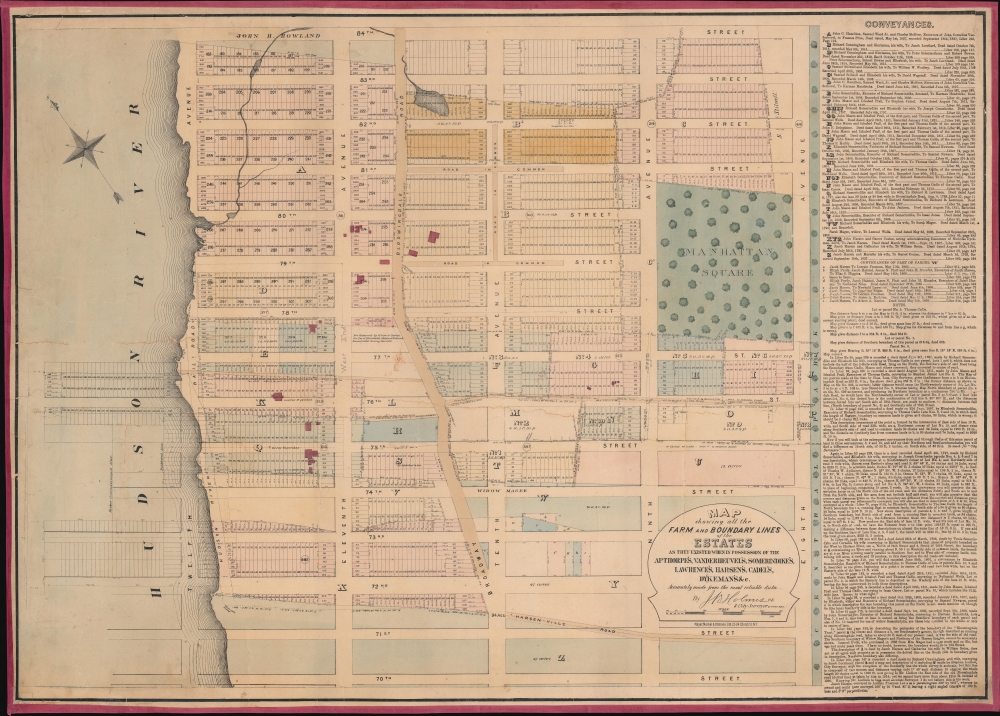
Map showing all the Farm and Boundary Lines of the Estates as they existed when in possession of the Apthorpe's, Vanderheuvel's, Sommeridike's, Lawrence's, Harsen's, Cadel's, Dykeman's etc.
1874 (undated) 27.75 x 38.75 in (70.485 x 98.425 cm) 1 : 1620
1874 (undated) 27.75 x 38.75 in (70.485 x 98.425 cm) 1 : 1620
Description
One of a handful of known examples of John Bute Holmes's c. 1874 cadastral map of the Upper West Side of Manhattan. The map covers from 70th Street to 84th Street and from the Hudson River to Central Park, including Manhattan Square, where the American Museum of Natural History would be constructed in the same year this map was issued. This area is the earliest developed part of the Upper West Side, which flourished as one of Manhattan's most desirable neighborhoods with the construction of Central Park.
Holmes became fascinated by the early history of Manhattan real estate ownership, recognizing the wealth to be accrued by accurately understanding the history of city land ownership, division, and inheritance. Moreover, Holmes allied himself with the corrupt Tweed administration, assuring himself and his allies even greater wealth and political power from the eminent domain seizure of old Manhattan estates. Holmes created a series of maps, reminiscent of John Randall's 'Farm Maps', overlaid with property data, showing the borders of old estates, and notating the breakup of the lands among various heirs. The complex work of compiling the maps earned Holmes a fortune, with one newspaper suggesting on his death in 1887 that some of his individual maps were worth more than 30,000 USD. There is no complete carto-bibliography of Holmes' maps, but we believe there to be at least 50 maps, possibly more.
Holmes' cadastral maps are today all extremely rare. Of the present map, only three examples are cited in the OCLC, with the NYPL possibly holding a fourth. Only a handful of examples are known to have changed hands privately in the last 50 years, with one appearing at Swann Galleries in 1986.
A Closer Look
This map is a cadastral map, that is, a map illustrating property lines and lots. It employs color coding, overprinting, and an alphanumeric system to identify both old property lines dating to the earliest days of Manhattan's settlement and modern street grid, including property lines compliant with the 1811 Commissioner's Plan. Old gentlemanly estates, most overlooking the Hudson, appear in red - these belonged to wealthy families, most of Dutch descent, who owned much of this land, among them Apthorpe, Vanderheuvel, and Sommeridike, names preserved in some of the UWS's most grandiose historic apartment buildings. Modern-day Broadway (Bloomingdale Road) winds from north to south. Proposed landfill expansions, including property lots, extend well into the Hudson River. To the right of the map, a long list of deeds and conveyances breaks down the area's real estate history.Holmes' 'Farm Maps'
In the early 19th century, most of Manhattan was undeveloped farmland, the property of wealthy landowners with claims dating to the Dutch period. The northern two-thirds of Manhattan were dotted with large farms and sprawling gentlemanly estates, many with great manor houses overlooking the Hudson. The Commissioner's Plan of 1811 and the 1807 Commission Law laid out the street grid through many of these properties and gave the city the right to claim such lands under eminent domain, providing due compensation to the landowners. While this work occurred early in lower Manhattan, central and upper Manhattan were not formally acquired by the city until the mid-19th century.Holmes became fascinated by the early history of Manhattan real estate ownership, recognizing the wealth to be accrued by accurately understanding the history of city land ownership, division, and inheritance. Moreover, Holmes allied himself with the corrupt Tweed administration, assuring himself and his allies even greater wealth and political power from the eminent domain seizure of old Manhattan estates. Holmes created a series of maps, reminiscent of John Randall's 'Farm Maps', overlaid with property data, showing the borders of old estates, and notating the breakup of the lands among various heirs. The complex work of compiling the maps earned Holmes a fortune, with one newspaper suggesting on his death in 1887 that some of his individual maps were worth more than 30,000 USD. There is no complete carto-bibliography of Holmes' maps, but we believe there to be at least 50 maps, possibly more.
Publication History and Census
This map was published by John Bute Holmes sometime between 1874 and 1878, probably on the earlier side, given the absence of the Natural History Museum in Manhattan Square. It was engraved and lithographed by the firm of Mayer, Merkel and Ottmann, who were located at 22-24 Church Street during this 4-year period. There is only one edition.Holmes' cadastral maps are today all extremely rare. Of the present map, only three examples are cited in the OCLC, with the NYPL possibly holding a fourth. Only a handful of examples are known to have changed hands privately in the last 50 years, with one appearing at Swann Galleries in 1986.
Cartographer
John Bute Holmes (March 31, 1822 - May 21, 1887) was an Irish civil engineer, city surveyor, and mapmaker based in New York City in the middle to latter 19th century. Holmes was described as a 'short, stout man, with curly gray hair, a smooth face, and a short, thick neck.' Holmes' father-in-law supplied funds for him to immigrate to America in 1840 and shortly thereafter, in 1844, he established himself in New York City. He briefly returned to Europe before once again settling in New York City in 1848. Apparently, according to several New York Times articles dating to the 1870s, Holmes was a man of dubious personal and moral character. He was involved in several legal disputes most of which were associated with his outrageous - even by modern standards - womanizing. In 1857 he was convicted of forgery of a marriage document and sentenced to 15 years of hard labor at Sing Sing, of which he served 5 before wealthy associates interceded on his behalf for an early release. Holmes seems to have been married to several different women at the same time and to have had an unfortunate attraction to exceptionally young women - one of whom, 16 year old May Chamberlayne claimed to be his wife and sued him for 50,000 USD. On another occasion he was found guilty of killing Brooklyn policeman David Gourly with whose wife he 'had been intimate.' Another woman, Miss Abrams, who he hired as a housekeeper, was repeatedly attacked by Holmes and ultimately driven to madness and was consigned to Bellevue Hospital, where she died. Although he attempted to flee the country rather than face conviction for 4th degree manslaughter, he was ultimately arrested and served one year in prison. During the American Civil War he ran for Alderman of the First Ward, in New York. Despite his legal issues, Holmes was a man of considerable means, with a personal fortune estimated between 100,000 and 500,000 USD - a significant sum in the late 19th century. Much of his wealth is associated with a series of important cadastral maps produced between 1867 and 1875 while he was employed as a surveyor and civil engineer under the corrupt Tweed regime. When Holmes died of an 'apoplectic fit' there was considerable wrangling over his estate among his 7 heirs and 11 children. The cream of his estate where his maps, some of which were valued at more than 30,000 USD in 1887. Holmes lived on a large farm-estate in Fanwood New Jersey. More by this mapmaker...
Condition
Good. Full professional restoration. Closed tear extending nineteen (19) inches through printed image.
References
OCLC 50560950.