This item has been sold, but you can get on the Waitlist to be notified if another example becomes available, or purchase a digital scan.
1884 Official Map of the Republic of Uruguay
Uruguay-escueladeartesyoficios-1884$2,750.00

Title
Mapa de la República oriental del Uruguay.
1884 (dated) 47 x 32.5 in (119.38 x 82.55 cm) 1 : 811000
1884 (dated) 47 x 32.5 in (119.38 x 82.55 cm) 1 : 811000
Description
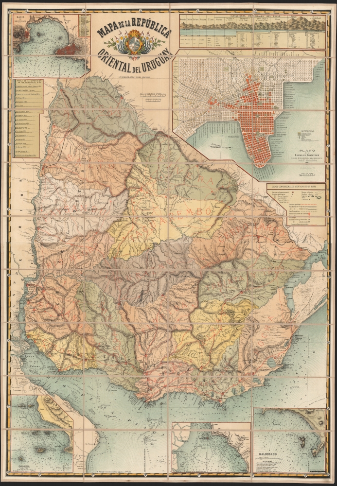
This is a spectacular, folding chromolithograph map of the Republic of Uruguay, published c. 1884 by Uruguay's La Escuela de Artes Y Oficios. It is among the first maps of Uruguay published there, and it appears to be the first official map of the Republic.
The details of the map suggest a country in flux. Towns are marked, as distinct from towns in construction, and abandoned ones. Likewise, fortresses, both garrisoned and abandoned, are indicated. Different marking conventions are used to distinguish post roads, railroads in use, and railroads under construction. Telegraph lines, too, are marked.
The plan of Montevideo is also suggestive of vigorous growth and change: a color code distinguishes those parts of the city that have been constructed, and those parts that remain to be built. Churches, markets, and theaters are shown, and both existing and prospective rail lines are marked.
A Closer Look
This richly informative work presents a central map of the Republic of Uruguay, divided into departments and detailing topography, roads, railroads, telegraph lines, and fortifications. It includes in the upper right a detailed plan of the city of Montevideo - indeed, a prospective plan, as it extends the city's grid beyond the limits of its coastline in a uniform manner. Above this city plan is a diagram showing the comparative heights of Uruguay's mountains. At the upper left is a detail chart of the bay of Montevideo; below it is a chart describing the lengths of Uruguay's rivers. The lower left corner contains a chart of the waters off Colonia, including San Gabriel Island, Farallon, de Hornos, and the other islands of that archipelago. A similar chart at the lower right details the approaches to Maldonado, and a further charts the strategic Isla de Martin Garcia. The subordinate harbor charts are filled with depth soundings, navigational guides, and notes regarding magnetic variations. The upper center of the work is dominated with an attractive title cartouche centered on the Uruguayan Coat of Arms.Abundant, Current Detail
While the foundation of this map can be dated to 1882 (see below) there is significant detail that cannot be from any source earlier than 1884. Most apparent of these is the presence, along the Brazilian border, of the new Department of Artigas (created by law on 1 October 1884.) The Capital of Artigas here is given as St. Eugenio del Cuareim. The capital was not renamed Artigas until 1915.The details of the map suggest a country in flux. Towns are marked, as distinct from towns in construction, and abandoned ones. Likewise, fortresses, both garrisoned and abandoned, are indicated. Different marking conventions are used to distinguish post roads, railroads in use, and railroads under construction. Telegraph lines, too, are marked.
The plan of Montevideo is also suggestive of vigorous growth and change: a color code distinguishes those parts of the city that have been constructed, and those parts that remain to be built. Churches, markets, and theaters are shown, and both existing and prospective rail lines are marked.
An Obscure Authorship, or Obscured?
The detail of the map, broadly, appears to be drawn from the individual Departmental maps included in Album de la república O. del Uruguay, authored by Francisco A. Berra, Agustin de Vedia, and Cárlos Maria de Pena for presentation at the 1882 Buenos Aires Continental Exposition. The city plan at the upper right also appears to be drawn from the same work, or from a mutual, unknown source. Berra, the Album's primary author, is generally credited with the maps accompanying it. The conspicuous absence of his name on this map may be political. During the 1882 - 1886 presidency of Máximo Santos, Berra fell out of favor and his history of Uruguay fell to the government censors. His name would not have been considered fit for an official document of this grandeur.A Government Publication
The corporate author credited with this map, La Escuela de Artes Y Oficios, was a school founded in 1878 during the presidency of Lorenzo Latorre, and administered by Uruguay's military beginning in 1878. Its students - youth detainees of the police and army - were taught to read and taught a trade, as part of the authoritarian government's program of modernization. Printing, evidently, was among the trades espoused by the school: their imprint appears on an array of official government publications, as well as private works such as volumes of poetry. This, however, is the only map attributed to La Escuela. That being the case, its beauty and quality of execution is remarkable.Chromolithography
Chromolithography, sometimes called oleography, is a color lithographic technique developed in the mid-19th century. The process involved using multiple lithographic stones, one for each color, to yield a rich composite effect. Oftentimes, the process would start with a black basecoat upon which subsequent colors were layered. Some chromolithographs used 30 or more separate lithographic stones to achieve the desired product. Chromolithograph color could also be effectively blended for even more dramatic results. The process became extremely popular in the late 19th and early 20th centuries when it emerged as the dominant method of color printing. The vivid color chromolithography produced made it exceptionally effective for advertising and propaganda imagery.Publication History and Census
This map is typically dated 1884, or more conservatively, 1885. Based on its content, it was certainly completed no earlier than October 1884. It is unlikely to have been produced any later than 1887, the year La Escuela's administration passed from the military to the Ministry of Justice, Worship and Public Instruction, resulting in the school's name change to Escuela Nacional de Artes y Oficios. The map is rare: we see only six copies recorded in OCLC, at the Bibliothèque National de France, the British Library, Harvard, Cambridge, the Staatsbibliothek zu Berlin, and Eth Bibliothek Zurich. This is the only example that has appeared on the market; we find none in auction records or dealers' catalogs.CartographerS
La Escuela de Artes Y Oficios (1878 - 1887) was a school developed in Montevideo, Uruguay, as part of that country's modernization process, both as an instrument of education and of social control. It was founded on December 31, 1878, during the presidency of Lorenzo Latorre. At that time it was located within a military compound and was administered directly by the Ministry of War: its students were young people detained by the police or the army. These were taught to read, and instructed in a trade during their detention. Printing - both letterpress and lithography - appear to have numbered among these trades: the school published an array of works during its existence, ranging from books of poetry to official statistical government publications. They published one map: Mapa de la republica oriental del Uruguay, whose cartographer is not credited. Its publication through a military office would classify it as an official document. The Escuela remained an office of the military until 1887, at which point it was passed to the Ministry of Justice, Worship and Public Instruction, and its name changed to Escuela Nacional de Artes y Oficios.. The institution survived several changes of name, and is known now as Univesidad del Trabajo del Uruguay. More by this mapmaker...
Francisco Antonio Berra (December 3, 1844 - March 13, 1906) was an Argentine lawyer, journalist, historian, and educator who lived and worked primarily in Montevideo, Uruguay. He was born in San Miguel del Monte, Buenos Aires province, but at the age of 8 his family moved to Uruguay. In 1865 he settled in Montevideo to study law at the University, from which he earned a law degree in 1872. He was a member of the Society of Friends of Popular Education and was a friend and colleague with Jose Pedro Varela; the group was instrumental in laying the foundations for public schooling and modern pedagogy in Uruguay. Berra was also active as a lawyer and journalist, with a political focus. It was primarily his writings on pedagogy which would bring him to Buenos Aires in 1882 as part of the first Pedagogical Congress installed in South America, which held sessions in Buenos Aires.
Berra's 'Historical Sketch of the Oriental Republic of Uruguay' fell afoul of government censors during the presidency of Máximo Santos (1882-1886) forcing Berra to flee the country to his native Buenos Aires. Despite this, he remained active in discussing how Uruguayan history ought to be presented in schools, corresponding with Uruguayan historian Carlos María Ramírez. These letters resulted in several published works. He became general director of Schools in the La Plata province in 1894. Apart from a brief return to Montevideo, he would spend his remaining years in La Plata. Learn More...
Condition
Excellent. Color lithograph with original hand tinting, printed to two sheets, dissected and mounted for folding. With the label of Paris mapseller Lanée (circa 1890).
References
OCLC 1108872130.