1961 General Drafting Road Map and Pictorial Map of the United States
USAStandardOil-generaldrafting-1961$250.00


Title
Standard Oil Road Map of the United States / Standard Oil Souvenir Map: 75 Years of Oil Progress.
1961 (undated) 24 x 33 in (60.96 x 83.82 cm) 1 : 5700000
1961 (undated) 24 x 33 in (60.96 x 83.82 cm) 1 : 5700000
Description
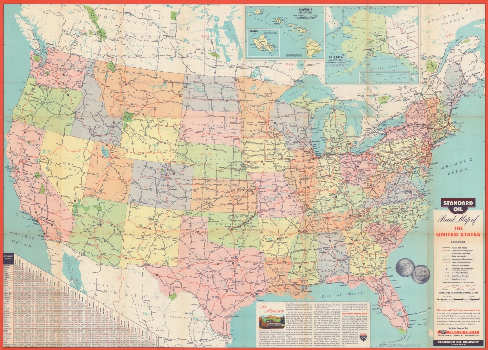
A large-format double-sided map of the United States produced in 1961 by the General Drafting Corporation for Standard Oil of Kentucky (also known as Kyso). Together, they highlight the rapid expansion of highways and interstates across the country, as well as the impact of the development of the oil industry on daily life.
This map was published in the wake of the Federal-Aid Highway Act of 1956, which created the U.S. Interstate system, here with both completed and projected routes noted. A text box at bottom touts the natural beauty of the U.S. and discusses the ongoing construction of the interstates.
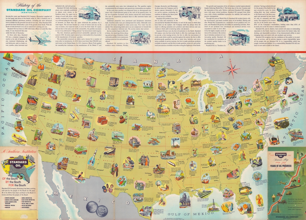
At top is a history of Standard Oil of Kentucky, which neatly avoids the company's early history as part of the wider Standard Oil Trust, and the latter's breakup due to a Supreme Court decision in 1911, but instead repeatedly emphasizes the company's connections with the South. When folded, the back cover continues this theme, proclaiming that Standard Oil is a southern Company - 'Of the South, By the South, For the South.' Incidentally, the same year this map was published Standard Oil of Kentucky was acquired by Standard Oil of California (Chevron).
A Closer Look
The recto map displays the continental United States along with portions of Canada and Mexico. States are shaded different colors to distinguish them more easily. Roads and highways are indicated in detail, as explained in a legend at right, as are cities and waterways. At top, inset maps of the recently added states of Hawaii and Alaska are included. A handy table of approximate distances between major metropolitan areas appears at bottom-left.This map was published in the wake of the Federal-Aid Highway Act of 1956, which created the U.S. Interstate system, here with both completed and projected routes noted. A text box at bottom touts the natural beauty of the U.S. and discusses the ongoing construction of the interstates.
Verso Content
A pictorial map of the United States occupies the verso, emphasizing products used throughout the country that are derived from oil. From cosmetics and clothing to chemicals and heavy industry, the message is clear that oil and its derivative products are both extremely versatile and essential for modern life.At top is a history of Standard Oil of Kentucky, which neatly avoids the company's early history as part of the wider Standard Oil Trust, and the latter's breakup due to a Supreme Court decision in 1911, but instead repeatedly emphasizes the company's connections with the South. When folded, the back cover continues this theme, proclaiming that Standard Oil is a southern Company - 'Of the South, By the South, For the South.' Incidentally, the same year this map was published Standard Oil of Kentucky was acquired by Standard Oil of California (Chevron).
Publication History and Census
These maps were produced in 1961 by the General Drafting Corporation for Standard Oil of Kentucky. They are quite rare in institutional collections, only being listed among the holdings of the University of Kentucky.Cartographer
General Drafting Corporation (1909 - 1992) was one of the 'Big Three' publishers of road maps between 1930 and 1970, along with H. M. Gousha and Rand McNally. Founded in 1909, Otto G. Lindberg, an immigrant from Finland and the company's founder, began his business with a borrowed drafting board and a $500 loan from his father. At the time only twenty-three years old, Lindberg advertised his business as 'any and all general drafting' and was based out of 170 Broadway in New York City. Only two years later, in 1911, the firm secured its first contract from the American Automobile Association to make 'road maps'. Lindberg incorporated his business in 1914 and became its first Chairman of the Board, a position he held until his death in 1968. Lindberg persuaded Standard Oil of New Jersey to let him draw the 'best' road map of the state that they had ever seen, and Standard Oil would distribute it for free. Sufficiently impressed with the finished product, Standard contracted General Drafting to make all their road maps - a relationship that lasted another six decades. This relationship allowed General Drafting to work exclusively for Standard Oil, but when oil companies stopped providing free maps, General Drafting was in a bind. The company tried to expand into the retail map market, and it of course continued creating maps for Exxon (the new name for Standard Oil) to sell, but its returns continued to decline. The firm was purchased in 1992 by Langenscheidt and subsequently absorbed into the American Map Company. General Drafting's state maps became this company's 'Travelvision' lineup. More by this mapmaker...
Condition
Average. Wear and toning along fold lines, with loss at fold intersections and edge.
References
OCLC 35161853.