This item has been sold, but you can get on the Waitlist to be notified if another example becomes available, or purchase a digital scan.
1845 Mitchell Wall Map of the United States (partial Republic of Texas)
USAwall-mitchell-1844$1,550.00

Title
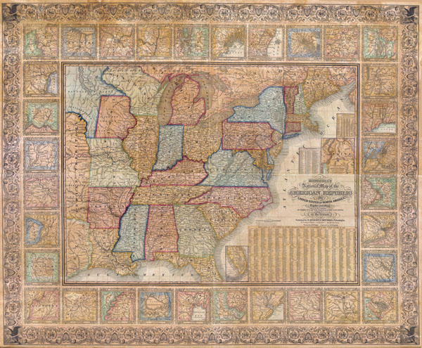
Mitchell’s National Map of the American Republic or The United States of North America. Together with Maps of the Vicinities of Thirty-Two Principal Cities and Towns in the Union
1844 (dated) 38 x 49 in (96.52 x 124.46 cm)
1844 (dated) 38 x 49 in (96.52 x 124.46 cm)
Description
The S. A Mitchell firm published this map, both in wall and folding pocket format, from 1843 to 1850. It is considered a highly important work of mid 19th century American cartography. Through its multiple issues historians can follow the rapidly changing national and domestic political borders. This particular map dates to 1845. This map was drawn by J. H. Young and engraved by H. H. Brightly. Includes numerous features from an inset map of Maine's northern boundary as defined by the Treaty of 1842 to thirty-two inset city plans. City plans include, among others, Raleigh, North Carolina; Richmond, Virginia; Louisville and Frankfort, Kentucky; Springfield, Illinois; Indianapolis, Indiana; St. Louis, Missouri; Rochester, New York; New Haven and Hartford, Connecticut; Burlington, Vermont; Providence, Rhode Island; Portland, Maine. A detailed table located below the title cartouche relations populations statistics for every county in each state or territory. Dated and copyrighted 1845.
Cartographer
Samuel Augustus Mitchell (March 20, 1792 - December 20, 1868) began his map publishing career in the early 1830s. Mitchell was born in Bristol, Connecticut. He relocated to Philadelphia in 1821. Having worked as a school teacher and a geographical writer, Mitchell was frustrated with the low quality and inaccuracy of school texts of the period. His first maps were an attempt to rectify this problem. In the next 20 years Mitchell would become the most prominent American map publisher of the mid-19th century. Mitchell worked with prominent engravers J. H. Young, H. S. Tanner, and H. N. Burroughs before attaining the full copyright on his maps in 1847. In 1849 Mitchell either partnered with or sold his plates to Thomas, Cowperthwait and Company who continued to publish the Mitchell's Universal Atlas. By about 1856 most of the Mitchell plates and copyrights were acquired by Charles Desilver who continued to publish the maps, many with modified borders and color schemes, until Mitchell's son, Samuel Augustus Mitchell Junior, entered the picture. In 1859, S.A. Mitchell Jr. purchased most of the plates back from Desilver and introduced his own floral motif border. From 1860 on, he published his own editions of the New General Atlas. The younger Mitchell became as prominent as his father, publishing maps and atlases until 1887, when most of the copyrights were again sold and the Mitchell firm closed its doors for the final time. More by this mapmaker...
Condition
Very good condition with original color and original wooden rollers. Professionally conserved, restored, cleaned and re-backed with new linen. The whole is in extremely good condition. Usual overall toning. Minor damp browning along upper margin – see photos. Measurements do not include original rollers, which are attached but can be removed at the buyer's request.
References
Rumsey 3345; Ristow, p. 310.