This item has been sold, but you can get on the Waitlist to be notified if another example becomes available, or purchase a digital scan.
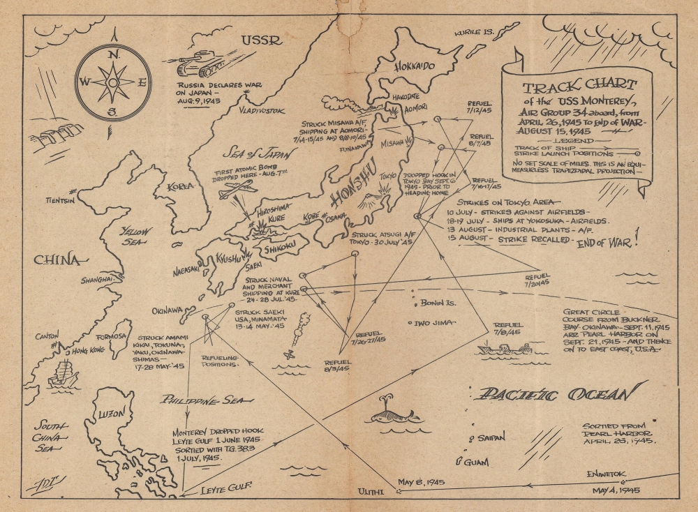
1945 Route Map of the U.S.S. <i>Monterey</i> in the Pacific Theater
USSMontereyTrack-unknown-1945$125.00


Title
Track Chart of the USS Monterey, Air Group 34 aboard, from April 26, 1945 to End of War - August 15, 1945.
1945 (undated) 7 x 9.5 in (17.78 x 24.13 cm)
1945 (undated) 7 x 9.5 in (17.78 x 24.13 cm)
Description
A rare find in an underappreciated genre, this is a c. 1945 pictorial World War II route map of the U.S.S. Monterey, an Independence-class light aircraft carrier. Route maps focusing on the Pacific Theater are surprisingly rare and of those we have encountered most focus on the cruises of Navy ships.
A Closer Look
With Japan just above center, the U.S.S. Monterey's movements from late April through late September 1945 (only a few weeks after the end of the war) appear in some detail. Air raids over Japan and Okinawa are chronicled, along with attacks on Japanese shipping, refueling stops, and time spent at anchpr in Leyte Gulf and Tokyo Bay. A few events in the wider war are noted as well, including the dropping of the atomic bomb on Hiroshima and Russia's declaration of war on Japan.The U.S.S. Monterey
The U.S.S. Monterey, a U.S. Navy Independence-class light aircraft carrier, was originally laid down as the Dayton, a light cruiser, on. December 29, 1941. It was converted to an aircraft carrier on March 27, 1942, and renamed the Monterey four days later. The Monterey launched on February 29, 1943, and after its shakedown cruise deployed to the Pacific. Monterey served in the Pacific until the end of the war and earned 11 battle stars. After the end of the war, she took part in Operation Magic Carpet and undertook several voyages between Naples and Norfolk bringing men home from Europe. Decommissioned in 1947, Monterey was reactivated during the Korean War, when she helped train carrier pilots in Pensacola. She was decommissioned against in 1956, and sold for scrap in May 1971.World War II Route Maps
Maps tracing unit movements during World War II were created by both American and British forces during and after the war. As a genre, these maps represent a broad range of aesthetics, from the purely functional that label places and provide dates, to the artistic, even comic. Many combine the three and provide a visually striking but historically informative summary of the unit's peregrinations.Publication History and Census
This map was created by an unknown artist and likely published aboard the U.S.S. Monterey during its voyage back to New York. The Monterey left Pearl Harbor on September 21, 1945, and arrived in New York on October 17, 1945, and our assertion that this piece was published during that cruise is made based on the observation that it resembles many publications published during World War II on board Navy ships in the Pacific. Also, if this map had been published after the Monterey's arrival in New York, that event would have most likely been included. This is the only known cataloged example of the present map.Condition
Fair. Area of infill at top center with manuscript border. Verso repair to centerfold separation. Closed tear extending 2 inches into title cartouche professionally repaired on verso. Closed tear extending 2.5 inches through printed area to right of centerfold professionally repaired on verso. Text on verso.