This item has been sold, but you can get on the Waitlist to be notified if another example becomes available, or purchase a digital scan.
1938 Council of People's Commissars Map of the World (Soviet Union)
USSRWorldMap-snk-1938$2,250.00

Title
A Political Map of the World (ПОЛИТИЧЕСКАЯ КАРТА МИРА)
1938 (dated) 45 x 74.5 in (114.3 x 189.23 cm) 1 : 20000000
1938 (dated) 45 x 74.5 in (114.3 x 189.23 cm) 1 : 20000000
Description
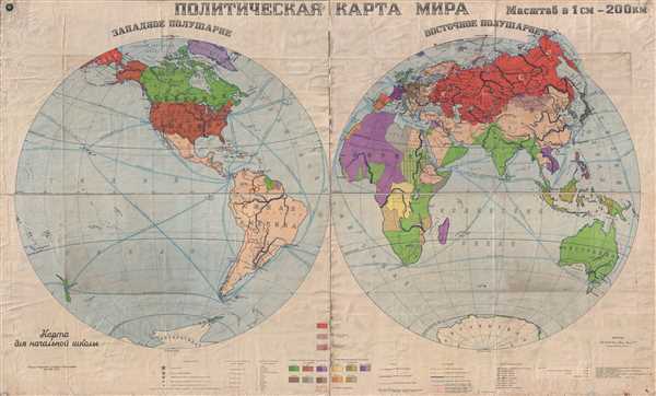
This is a 1938 Council of People's Commissars world map in two hemispheres. With the Western Hemisphere on the left and the Eastern Hemisphere on the right, the map depicts the world from the coast of Kamchatka and the Central Pacific Ocean across North and South America and the Atlantic Ocean to Europe, Africa, and the Middle East before reaching Russia (labeled as the Soviet Union from Eastern Europe to the Pacific), Asia, and Australia. The highlights of the map are three lines tracing the routes of three different Soviet flights: one which terminated at the North Pole and two others which continued over the Pole and ended on the West Coast of North America, each by Soviet pilots.
Polar Flight by Otto Yulyevic Scmidt
The first of these accomplishments was the airborne expedition to the Arctic supervised by Otto Yulyevich Schmidt. It was the first of its kind to land on the ice within thirteen miles of the North Pole and establish a research station, which became known as 'North Pole-1'. On the map, the route is noted as 'Полет экспедиции на северный полюс под начальством о. ю. шмидта в 1937 г', which translates to 'Flight of the expedition to the North Pole under the command of O. U. Schmidt in 1937.' Schmidt was a man of many talents. Over the course of his life he was a scientist, mathematician, and astronomer, among many other professions. He was declared a Hero of the Soviet Union and awarded three Orders of Lenin, among various other orders and medals.
Polar Flight by Valery Chkalov
The groundbreaking non-stop flight from Moscow to the United States under the command of Valery Chkalov in June 1937 over the North Pole proved that the Polar Route was feasible. Chkalov's flight is noted on the map as ' Полет в америку через северный полюс под начальством чкалова в 1937 г', which translates to 'Flight to America across the North Pole under the command of Chkalov in 1937'. Like Schmidt, Chkalov was declared a Hero of the Soviet Union. He filled his role as one of Stalin's 'New Soviet Men' when he died in a crash while piloting the prototype of the Polikarpov I-180 in December 1938.
Polar Flight by Mikhail Mikhailovich Gromov
The third and last of the three flights depicted here was supervised by Mikhail Mikhaylovich Gromov. This flight established a new non-stop flight distance record, flying a record 6,306 miles from Moscow to San Jacinto, California via the North Pole. Gromov's flight is indicated by the text ' Полет в америку через северный полюс под начальством громова в 1937 г', which translates to 'Flight to America across the North Pole under the command of Gromov in 1937'. Following the flight, Gromov became the first director of the Flight Research Institute in Zhukovsky.
Unknown to these three men, and completely unpredictable, is that the Arctic would become the primary theater for both Soviet and American nuclear bomber flights during the Cold War
Capitalism vs. Communism
On a grander scale, the political duality between communism and capitalism that would lead to the Cold War is brilliantly apparent on this piece, as the Western powers of Britain, the U.S., and France, along with Germany, Italy, and Japan, are labeled as ‘The Main Capitalist Powers’. Their overseas possessions, i.e. colonies, are shaded slightly lighter than the metropole or mother country. For example, India is a lighter shade than Great Britain, French West Africa is a lighter shade of purple than France, and the Philippines are a lighter shade of orange than the United States. The interwar period was the beginning of the end for overseas empires, with independence movements sprouting out of President Wilson's post-war rhetoric about 'self-determination', although he didn't necessarily mean for his message to be applied to the colonial world, just Eastern Europe.
World geography also illustrates a world on the brink of war. Manchukuo, a puppet state of the Empire of Japan created in 1932 in Northeast China and Inner Mongolia, is depicted here. Although the Second Sino-Japanese War had been raging for less than a year, hostilities and tension had been high between the two nations since the Mukden Incident allowed Japan the opportunity to establish Manchukuo. Korea is, of course, shaded as an overseas territory of Japan. In Europe, Germany's borders reflect the Anschluss, the annexation of Austria by Nazi Germany, although the annexation of the Sudentenland is not reflected here.
This is a first edition of this map and the only known example. It was created by the Main Department of Geodesy and Cartography under the SNK of the USSR (Главное управление геодезии и картографии при СНК СССР) in 1938. The main editor of this map was A. Durov and the technical editor was S. Krylov. A price list, included along the bottom of the map, states that in 1938 the map itself cost 7 rubles in 1938, an edition backed on linen and including grommets cost 25 rubles, an edition backed on linen and mounted on rollers cost 29 rubles, and an edition backed on linen, mounted on rollers, and accompanied by a belt (presumably to wrap around the map to keep it contained when rolled up) cost 30 rubles.
Condition
Good. Very large map. Backed on linen. Wear along fold lines with some loosening of the map along the fold lines and the margins. Blank on verso.