This item has been sold, but you can get on the Waitlist to be notified if another example becomes available, or purchase a digital scan.
1867 Mitchell Map of Utah and Nevada
UtahNevada-mitchell-1867$112.50

Title
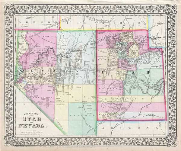
County Map of Utah and Nevada.
1867 (dated) 12 x 15 in (30.48 x 38.1 cm) 1 : 3000000
1867 (dated) 12 x 15 in (30.48 x 38.1 cm) 1 : 3000000
Description
A beautiful example of S. A. Mitchell Junior's 1867 map of Utah and Nevada. Covers both the state of Nevada and the Territory of Utah. Highly detailed with notations on proposed railroads, topographical features, springs and cities. Identifies a number of important east-west routes including the Overland Mail Route, the Telegraph Route, Beckwith's Route, the Hastings Road' and the Emigrant Road to California, the Wagon Road to Owyhee Mines, and others. Notates mineral deposits of gold and silver just across the border in Idaho, as well as Salt Beds in Nevada and Utah. Color coded at the county level One of the most interesting and ephemeral maps of this transitional region to appear in the mid 19th century. Features the vine motif border typical of Mitchell maps from the 1865-80 period. Prepared for inclusion as plate 54 in the 1867 issue of Mitchell's New General Atlas. Dated and copyrighted, 'Entered according to Act of Congress in the Year 1867 by S. Augustus Mitchell Jr. in the Clerk's Office of the District Court of the U.S. for the Eastern District of Pennsylvania.'
Cartographer
Samuel Augustus Mitchell (March 20, 1792 - December 20, 1868) began his map publishing career in the early 1830s. Mitchell was born in Bristol, Connecticut. He relocated to Philadelphia in 1821. Having worked as a school teacher and a geographical writer, Mitchell was frustrated with the low quality and inaccuracy of school texts of the period. His first maps were an attempt to rectify this problem. In the next 20 years Mitchell would become the most prominent American map publisher of the mid-19th century. Mitchell worked with prominent engravers J. H. Young, H. S. Tanner, and H. N. Burroughs before attaining the full copyright on his maps in 1847. In 1849 Mitchell either partnered with or sold his plates to Thomas, Cowperthwait and Company who continued to publish the Mitchell's Universal Atlas. By about 1856 most of the Mitchell plates and copyrights were acquired by Charles Desilver who continued to publish the maps, many with modified borders and color schemes, until Mitchell's son, Samuel Augustus Mitchell Junior, entered the picture. In 1859, S.A. Mitchell Jr. purchased most of the plates back from Desilver and introduced his own floral motif border. From 1860 on, he published his own editions of the New General Atlas. The younger Mitchell became as prominent as his father, publishing maps and atlases until 1887, when most of the copyrights were again sold and the Mitchell firm closed its doors for the final time. More by this mapmaker...
Source
Mitchell's New General Atlas, containing maps of the various countries of the World, plans of cities, etc., (1867 edition).
Condition
Very good. Some foxing throughout. Minor edge wear.
References
Rumsey 0579.041 (1868 edition).