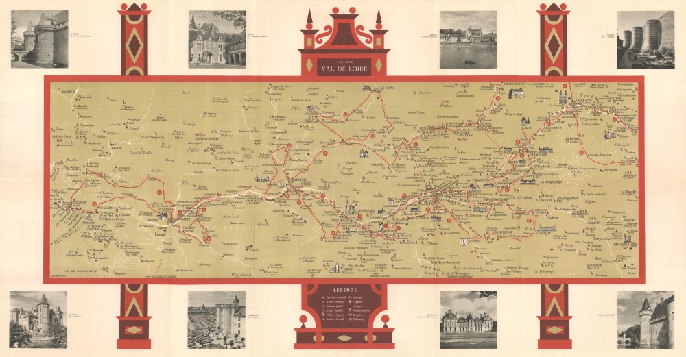
1951 French Department of Tourism Map of the Loire Valley (Chateaux)
ValdeLoire-sofcar-1951$300.00


Title
France Val de Loire.
1951 (undated) 16.75 x 32 in (42.545 x 81.28 cm) 1 : 500000
1951 (undated) 16.75 x 32 in (42.545 x 81.28 cm) 1 : 500000
Description
This is a c. 1951 French Department of Tourism map of the Loire Valley promoting the region's world-famous chateaux.
A Closer Look
The map depicts the Loire Valley from the Loire Estuary to just east of Orléans. Illustrations highlight the world-famous chateaux, including Chambord, Amboise, Valençay, and Azay-le-Rideau. Smaller icons mark less famous chateaux, Roman and feudal ruins, churches and other religious buildings, and wineries. Eight photographs in the border highlight the chateaux at Nantes, Talcy, Amboise, Angers, Sully-sur-Seine, Cheverny, Villandry, and Saumur. Information concerning specific chateaux occupies the verso, including visiting hours. Two poems are printed on the verso, one by La Fontaine and the other by Charles Péguy.Publication History and Census
This map was created by Sofcar and published by the French Ministère des Travaux publics, des transports et du tourisme c. 1951. We note 3 examples cataloged in OCLC: Library of Congress, the University of California Santa Barbara, and the University of Kansas.Condition
Very good. Light wear along original fold lines and at fold intersections. Text and printed images on verso.
References
OCLC 5488489, 698779775.