
1898 Ortega Paredes City Plan or Map of Valencia, Spain

This item has been sold.
Plano de Valencia.
Valencia published in Valencia!
Choose a Collection:
- Digital Map Information
- Suitable for large format printing
- Full resolution TIFF file
- ICC color profile embedded
- Delivered instantly via download link
This Item
Enquire
Valencia published in Valencia!
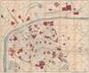
This is an 1898 Ramón Ortega Paredes city plan or map of Valencia, Spain, published in Valencia. Red highlights important buildings around the city, including hospitals, train stations, asylums, the cathedral, and the university. Streets are labeled throughout along with the bridges crossing the Turia River. The botanical garden appears in the lower left corner next to the Colegio San José.Publication History and Census
This map was created and published by Ramón Ortega Paredes in 1898. We note a single cataloged example in OCLC, which is part of the collection at the Biblioteca Nacional de España.Cartographer
Ramón Ortega Paredes (1851 - 1926) was a printer and publisher in Valencia, Spain. His father, Ramón Ortega Fort, founded the family's printing business in 1871, when Ramón Ortega Paredes was twenty years old. Ramón Ortega Fort directed the business until 1888, when Ramón Ortega Paredes took over the business. After Ramón Ortega Paredes died in 1926, his daughter María Ortega took over the family publishing firm. Further Details...
Condition
Very good. Verso repairs to fold separations.
References
OCLC 433710801.