
1924 Vancouver Map and Blueprint Company Folding Map of Vancouver

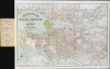

Indexed Guide Map of Greater Vancouver and District.
Booming Vancouver.
$750.00
Choose a Collection:
- Digital Map Information
- Suitable for large format printing
- Full resolution TIFF file
- ICC color profile embedded
- Delivered instantly via download link
This Item
Enquire
Booming Vancouver.
This is a detailed and attractive folding map of Greater Vancouver, produced in 1924 by the Vancouver Map and Blueprint Company. Both colorful and informative, this updated map highlights Vancouver's rapid growth in the first decades of the 20th century.A Closer Look
The map extends from Point Atkinson in the west to Port Moody in the east, presenting West and North Vancouver north of the Burrard Inlet and extending as far south as the Municipality of Richmond, beyond the Fraser River. Half-mile concentric circles radiate from City Hall; the map details railroads, electric railways, parks, districts, buildings, postal blocks, and streets. Port facilities are well detailed, as are the ferries and bridges connecting different parts of the city.A New Revision
The map was printed with some local fanfare in July of 1924. A newspaper announcement in the Vancouver Morning Sun proclaimed that thanks to this map,it will be no longer necessary now for strangers and new residents of the city to consult the policemen, the various information bureaus and the innocent passersby for knowledge of the streets of Vancouver, Point Grey, South Vancouver, North Vancouver, and West Vancouver.The announcement - no doubt supplied by the publisher itself - neglects to point out that the company had been from 1911 to 1921 been producing their Indexed Guide Map of the City of Vancouver and Suburbs upon which the present work is framed. Comparison of the present work with its precursor shows dramatic development of the city surrounds, particularly in the vicinity of Woodhaven and Coombe, and the western part of Point Grey. The grounds of the University of British Columbia show significant improvement over the prior maps.
Publication History and Census
The Vancouver Map and Blueprint Company produced this map in one edition of 1924. It is scarce on the market and in institutional collections: we see only 6 examples listed in OCLC.Cartographer
The Vancouver Map and Blueprint Company (fl. 1906 - c. 1957) was a publishing company founded in 1906 by Reginald William Purves (April 21, 1878 - October 23, 1941) and Jas. Harvie (dates unavailable). The firm specialized in city and municipal maps, and timber maps, the logging industry being one of the city's mainstays early in its development. Little is known of the company and its principals (although Purves was a noted yachtsman). Further Details...
Condition
Excellent. Marginal mend not impacting printed image.
References
OCLC 606372178.