This item has been sold, but you can get on the Waitlist to be notified if another example becomes available, or purchase a digital scan.
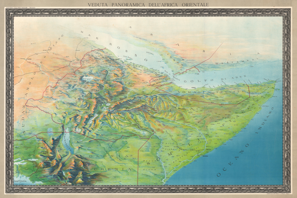
1935 Sulzer Bird's-Eye View Map of East Africa
VedutaAfricaOrient-sulzer-1935$500.00


Title
Veduta Panoramica Dell'Africa Orientale.
1935 (undated) 24.5 x 36.25 in (62.23 x 92.075 cm)
1935 (undated) 24.5 x 36.25 in (62.23 x 92.075 cm)
Description
This is a 1935 Carlo Sulzer bird's-eye view map of East Africa during the Second Italo-Ethiopian War (1935 - 1937). The map follows Mussolini's full-scale invasion of Ethiopia and the public anticipation that it would soon become an Italian colony.
A Closer Look
Sulzer's view looks north over East Africa, with Lake Victoria, Uganda, and Kenya in the foreground. Italian Somaliland, British Somaliland, French Somaliland, Ethiopia, Eritrea, and Anglo-Egyptian Sudan fall within the view, with the White Nile situated along the left border. (Modern-day Kenya, Somalia, Ethiopia, Eritrea, Sudan, South Sudan, and Djibouti.) The Red Sea and Arabia are in the background. Cities, towns, and villages are labeled throughout, including Addis Ababa (Addis Abeba), Mogadishu (Mogadiscio), Berbera, Khartoum (Chartum), Asmara, and Massaua. The Eastern Rift Mountains and the Ethiopian highlands are strikingly rendered, and a few peaks are labeled, including Mount Kenya. The region's extensive river network and its many lakes are emphasized.The Second Italo-Ethiopian War
The Second Italo-Ethiopian War (1935-1936) was a part of Fascist Italy's late-to-the-game attempt to establish itself as a colonial power in East Africa. Seeking to expand its empire and avenge its prior defeat at Adwa in 1896, Mussolini launched a full-scale invasion from Eritrea and Italian Somaliland. Despite fierce Ethiopian resistance under Emperor Haile Selassie, Italian forces overwhelmed the country and announced the annexation of Ethiopia, creating Italian East Africa. The League of Nations condemned the aggression but failed to take effective action. Nonetheless, Italian control was extremely limited, some might say non-existent, and faced with persistent and dogged resistance. The Italians were ousted in 1941 by a coalition of British Commonwealth forces and Ethiopian resistance fighters. The war exposed the weaknesses of international diplomacy and emboldened other fascist powers in the lead-up to World War II.Publication History and Census
This view was created by Carlo Sulzer and published by Antonio Vallardi Editore in 1935. We note 2 examples cataloged in OCLC, which are part of the collections at the Bibliotheek Universiteit van Amsterdam and the Staatsbibliothek zu Berlin. A handful of examples have appeared on the private market in recent years.Cartographer
Antonio Vallardi (1813 - 1876) was an Italian publisher and founder of the Antonio Vallardi publishing house. Born into a Milanese publishing family, his grandfather Cesare Vallardi (1736 - 1799) began publishing books in Contrada Santa Margherita in the 1750s. Vallardi's father, Pietro (1770 - 1819), and uncle Giuseppe (1784 - 1861) continued their father's publishing business but renamed the company Fratelli Vallardi and became prominent publishers of books and art prints. Pietro's sons, Franceso and Antonio, both founded their own publishing houses. Antonio Vallardi opened his publishing house in 1843, three years after his brother. Antonio's publishing house became known for academic and linguistic works, alongside the many maps and guides it published for the Touring Club. Antonio's descendants operated the publishing house until 1970, when they sold the firm to Garzanti. More by this mapmaker...
Condition
Very good. Light edge wear.
References
OCLC 778086647.