
This item below is out of stock, but another example (left) is available. To view the available item, click "Details."
Details
1838 S.D.U.K. City Map or Plan of Venice, Italy
1838 (dated) $450.00
1961 Ettore Adriano Augusto Vincitorio Map or Plan of Venice, Italy
Venezia-ettoreadriano-1961$75.00

Title
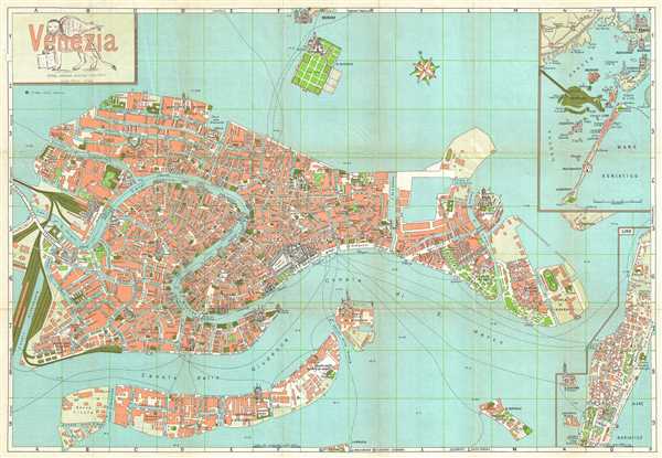
Venezia.
1961 (undated) 19 x 27 in (48.26 x 68.58 cm) 1 : 8000
1961 (undated) 19 x 27 in (48.26 x 68.58 cm) 1 : 8000
Description
This is a 1961 Ettore Augusto Adriano Vincitorio tourist map of Venice, Italy. The map depicts the entire city of Venice, from the train station to the Isola di S. Elena and from the Zattere ai Gesuati to the Quartiere Grimani. The map also depicts the Cimitero S. Michele as well as the northern half of Lido. The city buildings are depicted in a neutral color, while the blue of the lagoon and the canals and the green of the parks and churches stand out. Important buildings are drawn in profile, such as the Piazza San Marco, several of the cathedrals, and the train and bus stations. There is an inset map at the upper right corner which depicts the region, including Venice, Lido, and several other islands in the lagoon. Regional sites are depicted in profile.
On the verso there is a brief text about Venice in Italian, French, and English, as well as an index of locations. This map was published by Ettore Augusto Adriano Vincitorio in 1961 in Milan.
On the verso there is a brief text about Venice in Italian, French, and English, as well as an index of locations. This map was published by Ettore Augusto Adriano Vincitorio in 1961 in Milan.
Source
Ettore Augusto Adriano Vincitorio, 'Venezia, Nuova Guida Toponomastica Monumentale'.
Condition
Very good. Wear along original fold lines. Backed on archival tissue for stability.
References
OCLC 41472303.