This item has been sold, but you can get on the Waitlist to be notified if another example becomes available, or purchase a digital scan.
1941 Fisher Map of the Border Lakes (Vermilion, Trout Lake) Minnesota
VermilionPelican-fisher-1941$75.00

Title
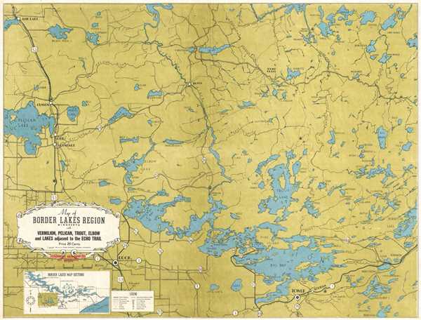
Map of Border Lakes Region Minnesota with Vermilion, Pelican, Trout, Elbow, and Lakes Adjacent to the Echo Trail.
1941 (dated) 16.5 x 22 in (41.91 x 55.88 cm) 1 : 125000
1941 (dated) 16.5 x 22 in (41.91 x 55.88 cm) 1 : 125000
Description
This is a 1941 W. A. Fisher Company map of the border lakes region of Minnesota of the vicinity around Lake Vermilion, Trout Lake, and Pelican Lake. The map depicts the region from Pelican Lake to Burntside Lake and from Loon Lake to Tower, Minnesota and State Highway 35. Within Lake Vermilion, various islands, bays, and points are labeled. Numerous lakes, rivers, and streams are illustrated, along with several trails. Distinctions are drawn between U.S. highways, state highways, and county roads. The quality of each road is noted as well, varying from paved highways to gravel roads and poor motor roads. The towns of Cusson, Orr, Glendale, and Cook are also labeled. Railroads, lookout stations, and campgrounds are also illustrated. A legend containing the different notations utilized on the map and a diagram of the border lakes map sections are located in the lower left corner, below the title cartouche.
This map was published by the W. A. Fisher Company in 1941, and appears to have been distributed (more likely sold) at Fisherman's Headquarters in Ely, Minnesota.
This map was published by the W. A. Fisher Company in 1941, and appears to have been distributed (more likely sold) at Fisherman's Headquarters in Ely, Minnesota.
Condition
Very good. Blank on verso.