This item has been sold, but you can get on the Waitlist to be notified if another example becomes available, or purchase a digital scan.
1863 Spangenberg Map of the Battle of Vicksburgh, Mississippi, Civil War
Vicksburgh-spangenberg-1863$250.00

Title
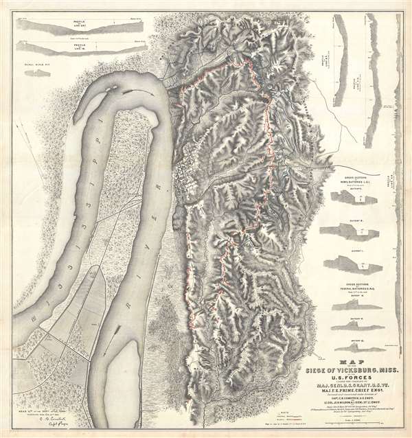
Map of the Siege of Vicksburg, Miss. By the U.S. Forces Under the Command of Genl. U.S. Grant, U.S. Vls. Maj. F.E. Prime, Chief Engr. Surveyed and constructed under the direction of Capt. C.B. Comstock, U.S. Engr.s and Lt. Col. Js. H. Wilson . . . Drawn by Chs. Spangenberg.
1863 (dated) 29 x 27.5 in (73.66 x 69.85 cm) 1 : 15840
1863 (dated) 29 x 27.5 in (73.66 x 69.85 cm) 1 : 15840
Description
This is a rare c. 1863 separate issue Charles Spangenberg Civil War map of the Siege of Vicksburg (May 18, 1863 - July 4, 1863). This map, considered one of the most attractive Civil War maps, is based upon a manuscript map drawn by military engineer Charles Spangenberg shortly after the siege. It covers Vicksburg and the surrounding hills as well as the full bend of the Mississippi River. To the right of the map there are various cross sections illustrating the Confederate and Union fortifications.
Siege of Vicksburg
The Siege of Vicksburg (May 18, 1863 - July 4, 1863) was a major military action in the American Civil War. During the campaign, Union commander Ulysses S. Grant crossed the Mississippi River south of Vicksburg at Bruinsburg with the Army of the Tennessee and drove northeast, winning battles at Port Gibson, Raymond, and Jackson. By May 14, he had forced Confederate Forces under John C. Pemberton into a defensive position around Vicksburg – the last major Confederate stronghold on the Mississippi River. Pemberton was under orders from Lee to hold Vicksburg at all costs and despite depleted forces, established a defensive perimeter and batteries around Vicksburg. Outmanned and out maneuvered, Pemberton's only hope was reinforcement from the Confederate Army of the West, which never materialized. After weeks of bloody siege warfare, Pemberton sued for peace on July 3rd and formally surrendered on July 4th. The capture of Vicksburg completed the second part of Grant's Anaconda Plan, cutting off Confederate communication with the Trans Mississippi and is considered, along with Lee's defeat at Gettysburg, a major turning point in the war.
This map is commonly dated 1863 due to the date appearing in the lower left quadrant. That date, however, refers to the Spangenberg manuscript, which survives at the Library of Congress. Most likely this map was issued shortly after the war, probably in 1865. There are several variants, including a reduced version that was issued in the 1880s. The present example, on fine heavy stock, is the original printing prepared in New York by engraver Joseph Schedler. Of curious note, the scale on the map, 1:15740 is wrong, with the actual scale coming it at 1:17000.
CartographerS
Charles Spangenberg(fl. c. 1862 - 1872) was a topographical draftsman active in the mid to late 19th century. Spangenberg served with the Union Army during the American Civil War (1861 - 1865). His name is attached to at least one important Civil War manuscript maps, of the Battle of Vicksburg, as well as published maps of multiple other battles. After the war, he was active in New York City, where he drew several maps for the New York Parks Commission. More by this mapmaker...
Joseph Schedler (April 22 1813 - December 12, 1887) was a New York based engraver, printer, lithographer, and globe maker active from about 1850 to at least 1889. Schedler was born in Germany and immigrated to the United States, a Forty-Eighter fleeing the German Revolutions of 1848-1849. He was active from at least 1850 when he partnered with fellow German immigrant, the landscape artist, painter, and engraver, Theodore August Liebler (1830 – 18??), to found the lithography firm of Schedler and Liebler, 129 William Street. The firm completed engraving work for J. H. Colton as early as 1852 but probably dissolved by 1854. Schedler filed a patent in 1878 for a crystallotype machine, a device the employed electrotyping to print textured crystalline surfaces. He is best known today as a globe maker. Joseph Schedler's globes won prizes at the Paris International Exhibition in 1867, the American Institute Fair in 1869 and the Vienna International Exhibition in 1873. From at least 1876 records suggest he relocated to Jersey City, New Jersey. Schedler's son, Herman, was also a globe maker, and inherited his father's business sometime around 1877, producing globes will to about 1901. Learn More...
Army Corps of Topographical Engineers (fl.1838 - 1863) refers to the an elite branch of the U.S. Army created on July 4, 1838 to perform civil mapping and survey work throughout the United States. The origins of the Corps of Topographical Engineers can be traced back to the American Revolutionary War, where General George Washington recognized the need for accurate surveys pursuant to military action. Shortly following the war, in 1779, a civilian engineering corps was created by act of Congress. Identified in 1802 by Thomas Jefferson, the "Corps of Engineers," which was based at West Point, the group participated in the War of 1812 and in later in the fortification of New Orleans. It was not until 1838, however, that a separate group of "Topographical Engineers" was formally recognized. This elite group, consisting only of officers, most of whom were trained in surveying and engineering by the esteemed Andrew Ellicott at West Point, never numbered more than 36 individuals - the best and brightest. This small but determined group played a central role in the mapping and exploration of the American West. Few branches of the military can boast such a distinguished alumni. Their names resonate throughout the map of the west and include John Charles Fremont, Zebulon Pike, George Meade, Kemble Warren, William Amiel Weeks, A. B. Gray, Randolph B. Marcy, James H. Simpson, Howard Stansbury, John W. Gunnison, William Ludlow, and Robert S. Williamson. The onset of the American Civil War brought an abrupt end to the surveying activity of the Topographical Engineers. Many of the most prominent engineers went on to distinguished military careers on both sides of the War Between the States. The Army Corps of Topographical Engineers itself was folded into the Corps of Engineers on March 31, 1863. Though the Army Corps of Engineers continues to do military and civil survey work to this day, the elite club of adventures that formed the Topographical Engineers were no more. Learn More...
Condition
Very good.
References
Rumsey 3858.000. Library of Congress, G3984.V8S5 1863 .S59. OCLC 1039347512. Stephenson, R. W., Civil War Maps; an Annotated List of Maps and Atlases in Map Collections of the Library of Congress, #285.