1869 Whitehead Map of Victoria, Australia, During the Victoria Gold Rush
Victoria-whitehead-1869$1,500.00

Title
Whitehead's Map of Victoria, with Alphabetical Key, 1869.
1869 (dated) 19.5 x 29.5 in (49.53 x 74.93 cm) 1 : 1150000
1869 (dated) 19.5 x 29.5 in (49.53 x 74.93 cm) 1 : 1150000
Description
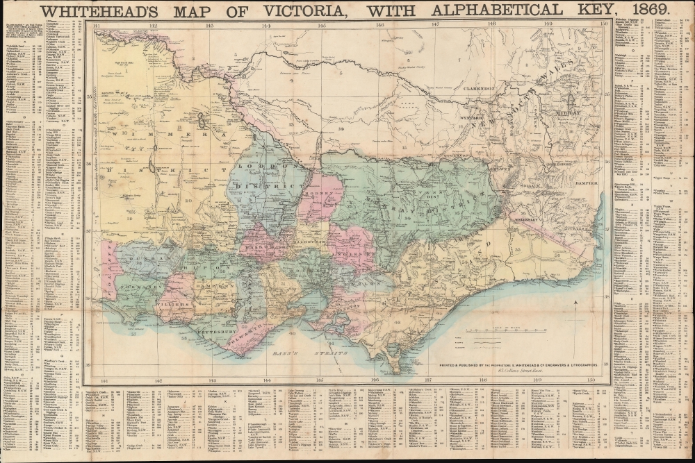
This is an 1869 Whitehead map of Victoria, Australia. The map is an early edition of one of the most successful cartographic enterprises of the Victoria Gold Rush Era. It also includes manuscript annotations marking gold diggings - 'x' marks the spot!
A Closer Look
Coverage embraces from the border between Victoria and South Australia to New South Wales and from New South Wales to Bass's Straits and Wilson's Promontory. Cities, towns, villages, and smaller settlements are labeled throughout and indexed in the borders. Individual dig sites are identified in Loddon and elsewhere. A series of manuscript 'X's appear in Wimmera District (situated on the map's left side) and Rippon District, which could indicate the claims of a prospector and, if so, a case when 'X' truly marks the spot! Roads, railroads, and telegraph lines are noted. Other annotations comment on vegetation and physical geography.The Victoria Gold Rush
The Victoria Gold Rush (c. 1851 - 1869) was inaugurated with the announcement that gold was discovered in Loddon District. Fortune-seekers from all over the world began pouring into Victoria. Hundreds of overnight towns sprang up. Recognizing a political and demographic sea change, Port Phillip District was permitted to secede from New South Wales to create the Colony of Victoria. Melbourne had a population of around 29,000 in 1851, which grew to over 500,000 by 1861, and then to 700,000 by 1869. Gold production in Victoria exceeded all other gold-producing regions, with the exception of California, with its highest annual yield reaching 3,053,744 troy ounces in 1856. Between 1851 and 1896 a total of 61,034,682 ounces of gold were extracted from mines in Victoria.Publication History and Census
This map was printed and published by Edward Whitehead and Company in 1869, making it an early edition in one of the most successful series of regional maps of Australia ever produced. Even so, this map is rare, with only four examples cataloged in the OCLC, all of which are in Australia: the University of Queensland, the State Library of New South Wales, the National Library of Australia, and the State Library of Victoria. It is also rare on the private market, with only a half-dozen examples from the entire run of the series appearing at auction in the last two decades.Cartographer
Edward Whitehead (fl. 1864 - 1897) was a printer and publisher active in Melbourne during the latter half of the 19th century. Whitehead founded his printing business at 67 Collins Street East in 1864 and, though not focused on maps, began publishing his eponymous series of map of Victoria in 1867. Whitehead saw an opportunity to produce highly accurate and detailed convenient folding maps of Victoria that incorporated an incredibly detailed index of place names for the newly-arriving immigrants and fortune seekers who flooded Victoria during the Victoria Gold Rush. His series of map of Victoria became one of the most successful and most profitable regional maps of Australia ever produced. More by this mapmaker...
Condition
Very good. Even overall toning. Foxing. Light wear along original fold lines. Dissected and mounted on linen in twenty-one panels. Some loss at fold intersections.
References
OCLC 948645527.