This item has been sold, but you can get on the Waitlist to be notified if another example becomes available.
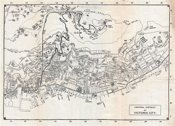
1925 Map of Hong Kong Central District and Victoria Peak
VictoriaPeakHongKong-unknown-1925$600.00

Title
Central District, of Victoria City.
1925 (undated) 10.5 x 15 in (26.67 x 38.1 cm) 1 : 8800
1925 (undated) 10.5 x 15 in (26.67 x 38.1 cm) 1 : 8800
Description
A very rare c. 1925 bi-lingual map of the Central District and Victoria Peak, Hong Kong. Oriented to the South, the map covers from Centre Street to Kennedy Street, and from Victoria Gap to Victoria Harbor. The map offers excellent street level detail naming various commercial wharfs and piers, as well as streets, parks, and important buildings – most identified in both Chinese and English. At the map extends southward towards the Peak, it switches entirely to English but becomes more detailed identifying numerous buildings and private residences. Named private residences include Richmond House, Tantallon, Altadena, Cragside (demolished 1974), the Cottage, and midlevel residences such as Hazeley, Fung Shui, Belvedere, and Altadena, among many others. It also identifies Peak locations such as the Formosa Peak Hospital, the Mount Austin Barracks, the Mountain Lodge, Bishop's Lodge, the Peak Hotel, etc. The map is undated, but based upon the content we have loosely dated it to 1925 - 1930. We have found no other reference to this map in any collection, public or private.
Condition
Very good condition. A few minor verso reinforcements on original fold lines. Blank on verso. Light soling right margin.