1851 Tallis and Rapkin Map of Victoria, Australia (with Gold Deposits)
VictoriaPortPhillip-tallis-1851$400.00

Title
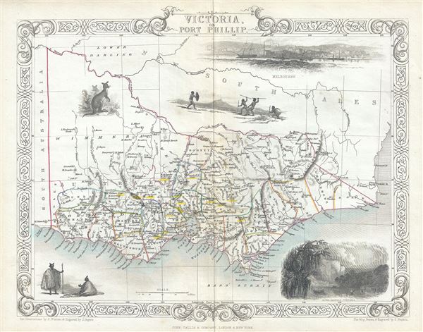
Victoria or Port Phillip.
1851 (undated) 10.5 x 14 in (26.67 x 35.56 cm) 1 : 2977920
1851 (undated) 10.5 x 14 in (26.67 x 35.56 cm) 1 : 2977920
Description
This is a scarce 1851 map of Victoria or Port Phillip, Australia by John Tallis. The map covers Victoria from Discovery Bay east past Melbourne to Mallacoota (Mallagoota). It also extends a considerable distance inland despite the region being only tenuously mapped. Victoria on this map is identified as 'Australia Felix' (the early name given to the lush green pastures of western Victoria). This map was issued in the same year as Victoria became an independent colony separate from New South Wales in July, 1851. This year also marked the beginning of the Australian gold rush, which would attract a large number of international immigrants, tripling its population within the next 20 years. The gold digging sites are marked in yellow throughout.
The map includes beautiful illustrations by H. Warren depicting, Melbourne, and the River Glenelg, a kangaroo and indigenous people or Aborigines. The whole has the highly decorative presentation and elaborate border distinctive of Tallis maps. This map was issued as part of the 1851 edition of John Tallis and Company's The Illustrated Atlas, And Modern History of the World.
The map includes beautiful illustrations by H. Warren depicting, Melbourne, and the River Glenelg, a kangaroo and indigenous people or Aborigines. The whole has the highly decorative presentation and elaborate border distinctive of Tallis maps. This map was issued as part of the 1851 edition of John Tallis and Company's The Illustrated Atlas, And Modern History of the World.
Cartographer
John Tallis and Company (1838 - 1851) published views, maps, and atlases in London from roughly 1838 to 1851. Their principal works, expanding upon the earlier maps of John Cary and Aaron Arrowsmith, include an 1838 collection of London Street Views and the 1849 Illustrated Atlas of the World. The firm’s primary engraver was John Rapkin, whose name and decorative vignettes appear on most Tallis maps. Due to the embellishments typical of Rapkin's work, many regard Tallis maps as the last bastion of English decorative cartography in the 19th century. Although most Tallis maps were originally issued uncolored, it was not uncommon for 19th century libraries to commission colorists to "complete" the atlas. The London Printing and Publishing Company of London and New York bought the rights for many Tallis maps in 1850 and continued issuing his Illustrated Atlas of the World until the mid-1850s. Specific Tallis maps later appeared in innumerable mid to late-19th century publications as illustrations and appendices. More by this mapmaker...
Source
Tallis, J. and F., The Illustrated Atlas, And Modern History Of The World Geographical, Political, Commercial & Statistical, 1851.
Condition
Very good. Minor wear along original centerfold. Minor spotting. Blank on verso.
References
Rumsey 0466.053. Phillips (Atlases) 804.