This item has been sold, but you can get on the Waitlist to be notified if another example becomes available, or purchase a digital scan.
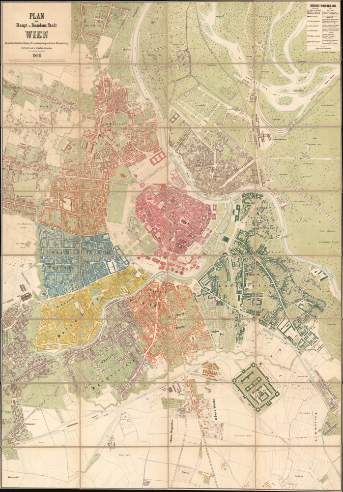
1866 Zettl Urban Planning Map of Vienna (building of the Ringstrasse)
Vienna-zettl-1866$2,000.00


Title
Plan der Haupt-u. Residenz Stadt Wein mit der neuen Bezirkseintheilung, Strassenbenennung under Häuser-Nummerirung.
1866 (dated) 56.75 x 39.5 in (144.145 x 100.33 cm) 1 : 5760
1866 (dated) 56.75 x 39.5 in (144.145 x 100.33 cm) 1 : 5760
Description
A rare and significant 1866 official planning map of Vienna (Wein) drawn by Ludwig Zettle, one of the civil engineers working on the development of the Ringstrasse and the expansion of the city beyond its historic walls. The work represents a transitional moment, both for Vienna and for the Austrian Empire as a whole. One year after this map was issued, the Hapsburg Empire was reorganized as the constitutional Austro-Hungarian Monarchy. Likewise, the deconstruction of Vienna's walls, the expansion of the city, and the integration of the existing suburbs are evidence of an ongoing democratization of Austria and Europe in general.
A Closer Look
This large map is expansive in its coverage of Vienna, embracing not just the historic center but also the 9 evolving suburbs and country beyond, each color-coded. Lots throughout are individually numbered, with major buildings laid out and projected construction ghosted in. The map includes parks with details extending to individual trees. Most significantly, this map illustrates the ongoing work on Vienna Ringstrasse, a project with which this map's maker, Zettl, was deeply involved. Likewise, the map offers a comprehensive overview of new suburban districts then being built, ghosting in new streets, civil buildings, parks, and more. For most Wieners, this is the first time these new parts of the city were committed to print.Vienna Ringstrasse
The construction of the Vienna Ringstrasse, which began in 1857 but was not completed until the 1890s, represents one of the most significant urban development projects of the 19th century, transforming Vienna into a showcase of grandeur and architectural innovation. Emperor Franz Joseph I (1830 - 1916) initiated this monumental endeavor to replace the outdated city walls and fortifications that had circumscribed Vienna's inner city with a splendid boulevard. To some extent, the project reflected the ongoing Hausmann Renovations in Paris, which made the city more accessible and grandiose but also served as a deterrent to revolutionary activity by allowing for easy military movement. As the Revolutions of 1848 proved, Austria was not immune to revolutionary sentiment. Moreover, as the city grew beyond its medieval walls, the Ringstrasse served to consolidate the dense historic center and the growing suburbs. This ambitious project further strove to reflect the empire's wealth, power, and cultural sophistication. The Ringstrasse encircles the historic Innere Stadt district and is adorned with opulent palaces, government buildings, cultural institutions, and public parks. Esteemed architects were commissioned to design buildings in a variety of historicist styles, including Neo-Gothic, Neo-Renaissance, and Neo-Baroque, contributing to the Ringstrasse's reputation as a symbol of the city's cosmopolitan ethos and architectural majesty.Publication History and Census
The civil engineer and architect Ludwig Zettl compiled this map. Although published in 1866, Zettl most certainly completed it in the prior year when employed with the Vienna Building Commission and City Expansion Commission - the organizations planning the Ringstrasse. We see no examples in the OCLC, but have identified holdings at the Wein Museum and at the Wienbibliothek im Rathaus. No history on the market.Cartographer
Ludwig Zettl (May 5, 1821 - April 14, 1891) was a Bohemian-Austrian architect and civil engineer active in the second half of the 19th century. Zettl was born in the Czech town of Poděbrady. He studied first at the Prague Polytechnikum, then, from 1843 - 1844, at the Vienna Polytechnische Institut. Afterward, he worked as an intern at the Vienna Staatsbaudepartement while studying architecture at the Akademie der Bildenden Künste Wien (Vienna Academy of Fine Arts). The internship proved valuable, as Zettl's connections yielded design contracts from 1850 onwards for state hospitals and prisons - the work for which he is most famous. By 1859, he was an Ingenieur I. Klasse (First Class Imperial Engineer). From 1859 to 1865, he was a member of the Vienna Building Commission and, as a technical representative of the ministry, a member of the City Expansion Commission. His plans greatly influenced the construction of the Wiener Ringstrassenzone, one of the world's most spectacular boulevards. His work earned him numerous accolades, including the Franz-Joseph-Orden (Franz-Joseph Order), the Ordens der Eisernen Krone (Order of the Iron Crown), and in 1883, a knighthood. More by this mapmaker...
Condition
Very good. Even overall toning. Light foxing in areas. Laid on original linen - which remains stable. Accompanies original marbled slipcase.
References
Wien Museum, #19473. Wienbibliothek im Rathaus, urn:nbn:at:AT-WBR-131247.