This item has been sold, but you can get on the Waitlist to be notified if another example becomes available.
1967 Civic Education Service Map of Vietnam During the Vietnam War
Vietnam-civiceducation-1967$212.50

Title
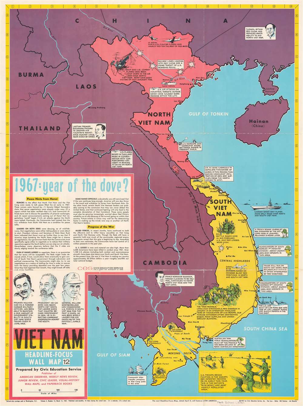
Vietnam. Headline-Focus Wall Map 12.
1967 (dated) 36.5 x 26.75 in (92.71 x 67.945 cm) 1 : 1900800
1967 (dated) 36.5 x 26.75 in (92.71 x 67.945 cm) 1 : 1900800
Description
This is a 1967 Civic Education Service pictorial map of Vietnam during the Vietnam War. Pictorial vignettes illustrate American, South Korean, and Australian forces fighting in South Vietnam, along with American bombing raids and North Vietnamese antiaircraft guns in North Vietnam. Text boxes provide short summaries of events. Text in the lower-left summarizes Vietnam in early 1967 with an emphasis that North Vietnam and the United States could soon enter peace talks.
The Vietnam War
The Vietnam War, known in Vietnam as the Resistance War Against America or simply the American War, raged between November 1, 1955, and April 30, 1975, when Saigon fell to the North Vietnamese. A complicated conflict with an even more complicated history and legacy, the Vietnam War pitted the North Vietnamese, led by Ho Chi Minh, against the South Vietnamese. The South Vietnamese were supported by the United States, while the Soviet Union and China supported the North Vietnamese. American anti-communist dogma and fear that 'if one country fell to Communism, then more would fall' drove participation in the far-off civil war. As the conflict grew, American involvement became increasingly overt. Finally, in 1964, American ground troops were sent into combat. In 1968, U.S. troop strength in Vietnam reached its maximum at 549,500 soldiers. The same year saw the Tet Offensive, the most successful North Vietnamese campaign against American forces, and a waning of American home front support. U.S. forces withdrew in January 1973, and Saigon fell to the North Vietnamese on April 30, 1975.Publication History and Census
This map was created and published by the Civic Education Service as Volume 4, Number 12 and dated March 13, 1967. We note a single example cataloged in OCLC, at the University of Washington. An example is also part of the David Rumsey Map Collection.Cartographer
The Civic Education Service (fl. c. 1939 - 1945, 1963 - 1972) was a publishing firm based in Washington, D.C. that produced maps and other visual material for academic purposes. Our research has led us to believe that an organization known as the Civic Education Service existed from c. 1939 - c. 1945 (during World War II) and from c. 1963 - c. 1972. We have been unable to determine if this is the same organization that was closed for almost twenty years, or if the organization that published maps and other educational materials in the 1960s and 1970s was unrelated to the Civic Education Service that published books, maps, and other materials during World War II. More by this mapmaker...
Condition
Good. Wear along original fold lines. Verso repairs to fold separations and at fold intersections. Some loss at all four fold intersections.
References
Rumsey 8372.000. OCLC 36083099.