
This item below is out of stock, but another example (left) is available. To view the available item, click "Details."
Details
1846 Bradford Map of Virginia (including West Virginia)
1846 (dated) $400.00
1838 Bradford Map of Virginia
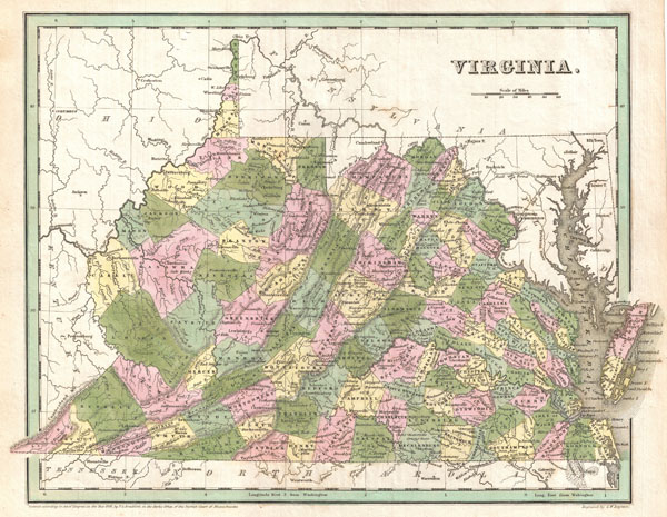
Virginia-bradford-1838$200.00

Title
Virginia.
1838 (dated) 11.5 x 15 in (29.21 x 38.1 cm)
1838 (dated) 11.5 x 15 in (29.21 x 38.1 cm)
Description
A fine example of T. G. Bradford's c. 1838 map of Virginia. This map covers all of what is today Virginia and West Virginia as well as the entire Chesapeake Bay and adjacent parts of Ohio, Pennsylvania North Carolina and Maryland. Cartographically sophisticated Bradford's map incorporates political and topographical data, naming cities, towns, rail lines, mountains, swamps, and rivers. Color coding at the county Level. Though dated 1838, this map is most likely from the 1841 edition of Bradford's Atlas. Exhibits fine coloration as well as G. W. Boynton's fine and elegant engraving.
Cartographer
Thomas Gamaliel Bradford (1802 - 1887) was born in Boston, Massachusetts, where he worked as an assistant editor for the Encyclopedia Americana. Bradford's first major cartographic work was his revision and subsequent republishing of an important French geography by Adrian Balbi, Abrege de Geographie published in America as Atlas Designed to Illustrate the Abridgment of Universal Geography, Modern and Ancient. Afterwards Bradford revised and expanded this work into his own important contributions to American cartography, the 1838 An Illustrated Atlas Geographical, Statistical and Historical of the United States and Adjacent Countries. Bradford's cartographic work is significant as among the first to record Texas as an independent nation. In his long career as a map publisher Bradford worked with William Davis Ticknor of Boston, Freeman Hunt of New York, Charles De Silver of Philadelphia, John Hinton, George Washington Boynton, and others. We have been able to discover little of Bradford's personal life. More by this mapmaker...
Source
Bradford, T., A General Atlas Of The World, With A Separate Map Of Each Of The United States Of America., 1841.
Condition
Very good condition. Blank on verso.
References
Rumsey 4453.027. Phillips (Atlases) 6092-29.