This item has been sold, but you can get on the Waitlist to be notified if another example becomes available, or purchase a digital scan.
1638 / 1662 Blaeu Map of the American Coast from Virginia to Florida
VirginiaeFloridae-blaeu-1638$1,250.00

Title
Virginiae Partis australis, et Floridae partis orientalis, interjacentiumque regionum Nova Descriptio.
1638 (undated) 15 x 19.5 in (38.1 x 49.53 cm) 1 : 2300000
1638 (undated) 15 x 19.5 in (38.1 x 49.53 cm) 1 : 2300000
Description
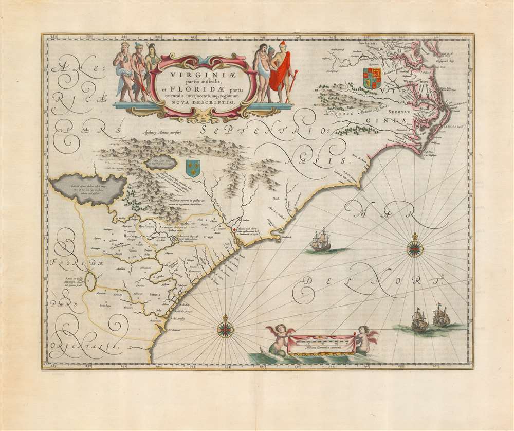
This is Willem Blaeu's beautiful map of Virginia and Florida, engraved in 1638 and appearing here in a superb example of the 1662 Atlas Maior edition, printed for Joan Blaeu's mammoth masterpiece atlas. This classic Dutch map, which encompassed the Carolinas and what would become Georgia and part of Florida, has been called 'the most correct map of this area yet to appear.' (Cumming)
The Map and its Sources
In terms of its scope, Blaeu's work covers the same region presented in the 1606 Jodocus Hondius Virginia Item et Floridae, but it improves greatly in the detail of the coastline. While the Hondius relied on the geographic models presented in the John White and Le Moyne maps of the end of the 16th century, Blaeu's map applied to this region the new cartographic data provided in the far superior, c. 1631 charts of Hessel Gerritz - most notably improving the delineation of the Outer Banks of the Carolinas, and the mouth of Chesapeake Bay. While many of the place names still derive from earlier maps, there are important advances: the settlement in 1621 of Newport News appeared on Blaeu's map for the first time, for example. Areas in the interior still appear to rely heavily the 1591 Le Moyne map - in particular the large Appalachian lake advertising the presence of native-gathered silver.A Long Tale of French and English Colonial Rivalry
The contesting claims to this stretch of American coast by the English and French not only appear in this map, but are inherent to the map's earliest precedents. Despite the much-improved coastlines after Gerritz, the core of the map's Virginia/Florida division has its roots in the two De Bry maps of these regions, and these were expressly maps of an English Colony (Virginia) and the French efforts to colonize further south (Florida). Both of these two regions bear coats of arms associating them with the two relevant colonizing powers. Elements such as the doomed fortress built by Laudonnière in 1562 in French Florida (and destroyed in 1565 by Pedro Menéndez de Avilés) further advertise the map's lineage.Classic Dutch Decorative Elements
The engraving epitomizes Blaeu's clear and legible style, while not neglecting the decorative elements which characterize his finest maps. Mountains and forests are rendered pictorially. The elegant cartouche is flanked by six Native American figures. The English coat of arms is displayed in the region of Virginia, whilst the French arms are shown reflecting that nation's efforts to colonize Florida in the 1560s. The sea areas are embellished with two fine compass roses, and three sailing ships. A banner displaying the scale in German miles is suspended between a pair of bat-winged, fish-tailed mer-putti.Close Copies by Fierce Competitors
The publication of this map in the 1638-40 French issue of Blaeu's Appendix puts it ever-so-narrowly ahead of the cartographically virtually identical map printed by Blaeu's primary competitor, Jansson, in 1639. The two maps are very frequently mistaken for one another, due to the lack of printer's imprint on either. There are telltales which identify the Blaeu clearly. First, the tribal names 'Powhatan.' and 'Secotan.' in the region of Virginia are printed followed with full stops, the punctuation lacking in the Jansson. There is as well an error in the Blaeu not present in his competitor's map: in the lower right of the Blaeu, the sequence of longitude reads '298, 299, 200' whilst the Jansson map has this corrected to '298, 299, 300.' We are aware of examples of the Jansson on the market now, misidentified as Blaeu.Publication History and Census
This map was engraved by Willem Blaeu, first appearing in the 1638 French edition of his Appendice. Thereafter it appeared in every edition of the Blaeu Atlas Novus, and as well in Joan Blaeu's Atlas Maior. There are two states of this plate that have been identified, of which this is the second (the left-hand mer-putti holding the scale cartouche has a fish-tail visible behind him and to the left which the first state lacks.) The verso text of this second-state example corresponds typographically to the 1662 Latin edition of the Atlas Maior, which corresponds as well to the superb paper quality and the broad margins present here. The separate map, in its many editions, is well-represented in institutional collections although it should be noted that the map is frequently misidentified as the Jansson, and vice-versa. There are eight examples in OCLC corresponding to the Atlas Maior.Cartographer
Joan (Johannes) Blaeu (September 23, 1596 - December 21, 1673) was a Dutch cartographer active in the 17th century. Joan was the son of Willem Janszoon Blaeu, founder of the Blaeu firm. Like his father Willem, Johannes was born in Alkmaar, North Holland. He studied Law, attaining a doctorate, before moving to Amsterdam to join the family mapmaking business. In 1633, Willem arranged for Johannes to take over Hessel Gerritsz's position as the official chartmaker of the Dutch East India Company, although little is known of his work for that organization, which was by contract and oath secretive. What is known is his work supplying the fabulously wealthy VOC with charts was exceedingly profitable. Where other cartographers often fell into financial ruin, the Blaeu firm thrived. It was most likely those profits that allowed the firm to publish the Theatrum Orbis Terrarum, sive, Atlas Novus, their most significant and best-known publication. When Willem Blaeu died in 1638, Johannes, along with his brother Cornelius Blaeu (1616 - 1648) took over the management of the Blaeu firm. In 1662, Joan and Cornelius produced a vastly expanded and updated work, the Atlas Maior, whose handful of editions ranged from 9 to an astonishing 12 volumes. Under the brothers' capable management, the firm continued to prosper until the 1672 Great Amsterdam Fire destroyed their offices and most of their printing plates. Johannes Blaeu, witnessing the destruction of his life's work, died in despondence the following year. He is buried in the Dutch Reformist cemetery of Westerkerk. Johannes Blaeu was survived by his son, also Johannes but commonly called Joan II, who inherited the family's VOC contract, for whom he compiled maps until 1712. More by this mapmaker...
Source
Blaeu, J., Atlas Maior, (Amsterdam: Blaeu) 1662.
In 1662 Joan Blaeu published his masterwork, which has been described as 'the greatest and finest atlas ever published' (Verwey, 1952): his monumental, eleven-volume Atlas Maior. This contained nearly six hundred maps, more than two hundred in excess of the Blaeus' mainstay the Atlas Novus. The former work already being renowned for the quality and beauty of its maps, Blaeu not only added copious material but improved the sophistication of his work: many of the newly-added maps utilized larger-sized presses and sheets, and the artistry applied to the engravings was often far superior to that of the earlier maps in the atlas - many of which by now were 30, and some more than 50 years old. Blaeu's Atlas Maior was published from 1662 to 1672, consisting of some 594 maps compiled into upwards of 9 volumes with some editions containing as many as 12 volumes. This triumphant work's publishing life was cut violently short when, in 1672, the Blaeu's mammoth workshop was destroyed by fire; surviving stock would be sold at auction between 1674 and 1677, occasionally appearing under the imprint of later Dutch printers such as Pieter Schenk and Pieter Mortier. The maps added to the Atlas Maior, owing to their tragically short publishing life, are among the hardest-to-find of the Blaeu maps.
Condition
Excellent. Generous margins. Minor mend, far from printed area. Latin text on verso. Fine original color.
References
OCLC 158815049. Van der Krogt, P. C. J., Koeman's Atlantes Neerlandici, 9400:2 variant b. Burden, P., The Mapping of North America, #253 state 2. Cumming, W., The Southeast in Early Maps, #41.