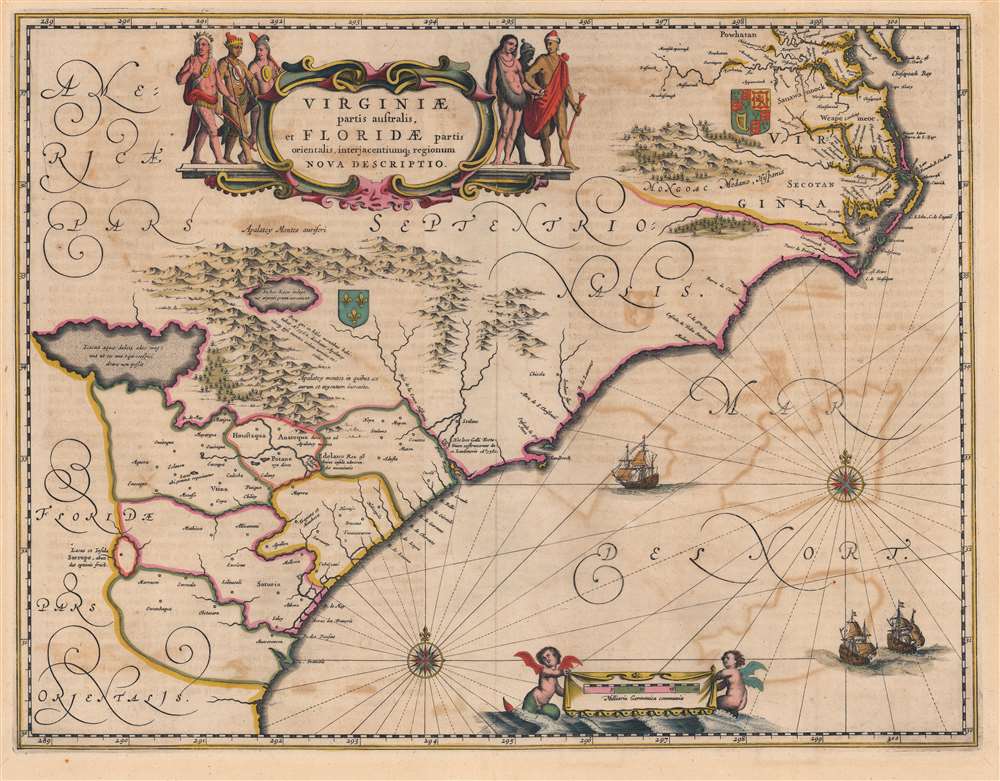
1644 Jansson Map of Carolina, Georgia, Florida, Virginia
VirginiaeFloridae-jansson-1644$2,000.00

Title
Virginiae Partis australis, et Floridae partis orientalis, interjacentiumque regionum Nova Descriptio.
1644 (undated) 15.25 x 20 in (38.735 x 50.8 cm) 1 : 2400000
1644 (undated) 15.25 x 20 in (38.735 x 50.8 cm) 1 : 2400000
Description
This is a beautiful c. 1644 Jan Jansson map of Virginia and Florida. This classic Dutch map, encompassing the Carolinas and the area that would become Georgia and part of Florida, was derived from that of Willem Blaeu, which has been called 'the most correct map of this area yet to appear' (Cumming). Blaeu's map was sufficiently authoritative for Jansson to make an extremely faithful copy. Both cartographers' maps would enjoy a long print life.
The Map and its Sources
In terms of its scope, the map covers the same region presented in the 1606 Jodocus Hondius Virginia Item et Floridae, but improves greatly in the detail. While the earlier Hondius relied on the geographic models presented in the late 16th century John White and Le Moyne maps, the present map includes the new cartographic data provided in the far superior, c. 1631 charts of Hessel Gerritz - most notably improving the delineation of the Outer Banks of the Carolinas, and the mouth of Chesapeake Bay. While many of the place names still derive from earlier maps, there are important advances. The settlement in 1621 of Newport News appeared on Blaeu's 1638 version of this map for the first time, for example. Areas in the interior still appear to rely heavily the 1591 Le Moyne map - in particular the large Appalachian lake advertising the presence of native-gathered silver.A Long Tale of French and English Colonial Rivalry
The contesting claims to this stretch of American coast by the English and French not only appear in this map, but are inherent to the map's earliest precedents. Despite the much-improved coastlines after Gerritz, the core of the map's Virginia/Florida division has its roots in the two De Bry maps of these regions, and these were expressly maps of an English Colony (Virginia) and the French efforts to colonize further south (Florida). Both regions bear coats of arms associating them with the relevant colonizing power. Elements such as the doomed fortress built by Laudonnière in 1562 in French Florida (and destroyed in 1565 by Pedro Menéndez de Avilés) further advertise the map's lineage.Classic Dutch Decorative Elements
The engraving exhibits a clear and legible style, while not neglecting the decorative elements which characterize the finest maps of the Dutch Golden Age. Mountains and forests are rendered pictorially. The elegant cartouche is flanked by six Native American figures. The English coat of arms is displayed in Virginia, whilst the French arms reflect efforts to colonize Florida in the 1560s. The sea areas are embellished with two fine compass roses, and three sailing ships. A banner displaying the scale in German miles is suspended between a pair of bat-winged, fish-tailed mer-putti.Close Copies by Fierce Competitors
The publication of this map in the 1639 French issue of the Jansson/ Hondius atlas puts it ever-so-narrowly behind the cartographically virtually identical 1638 map printed by Jansson's primary competitor, Blaeu. The two maps are frequently mistaken for one another, due to the lack of printer's imprint on either. There are nonetheless telltales which identify the Jansson clearly. First, the tribal names 'Powhatan' and 'Secotan' in the region of Virginia lack full stops, the punctuation present in the Blaeu. There is as well an error in the Blaeu not present in his competitor's map: in the lower right of the Blaeu, the sequence of longitude reads '298, 299, 200' whilst the Jansson map has this corrected to '298, 299, 300.'Publication History and Census
This map was engraved by Jan Jansson, first appearing in the 1639 French edition of the Nouvel Atlas. Thereafter it appeared in every edition of the Jansson atlases, all in a single state. The present example dates from a c. 1644 German edition of Jansson's Novus Atlas.Cartographer
Jan Jansson or Johannes Janssonius (1588 - 1664) was born in Arnhem, Holland. He was the son of a printer and bookseller and in 1612 married into the cartographically prominent Hondius family. Following his marriage he moved to Amsterdam where he worked as a book publisher. It was not until 1616 that Jansson produced his first maps, most of which were heavily influenced by Blaeu. In the mid 1630s Jansson partnered with his brother-in-law, Henricus Hondius, to produce his important work, the eleven volume Atlas Major. About this time, Jansson's name also begins to appear on Hondius reissues of notable Mercator/Hondius atlases. Jansson's last major work was his issue of the 1646 full edition of Jansson's English Country Maps. Following Jansson's death in 1664 the company was taken over by Jansson's brother-in-law Johannes Waesberger. Waesberger adopted the name of Jansonius and published a new Atlas Contractus in two volumes with Jansson's other son-in-law Elizée Weyerstraet with the imprint 'Joannis Janssonii haeredes' in 1666. These maps also refer to the firm of Janssonius-Waesbergius. The name of Moses Pitt, an English map publisher, was added to the Janssonius-Waesbergius imprint for maps printed in England for use in Pitt's English Atlas. More by this mapmaker...
Source
Jansson, J., Novus Atlas, (Amsterdam: Janssonius) 1644.
Condition
Very good. Verso repairs to centerfold separations.
References
OCLC 226394300. Burden, P., The Mapping of North America, #254. Cumming, W., The Southeast in Early Maps, #42. Van de Krogt 9400: 1B.