
1606 Hondius Map of Florida, Carolina, and Virginia

This item has been sold.
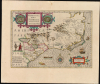
Virginiae Item et Floridae Americae Provinciarum, nova Descriptio.
Foundational Map of the Southeast.
- Digital Map Information
- Suitable for large format printing
- Full resolution TIFF file
- ICC color profile embedded
- Delivered instantly via download link
Foundational Map of the Southeast.
This is a beautiful, original color example of Jodocus Hondius's long-lived and influential map of the American southeast: the region spanning from northern Florida to the Chesapeake Bay. By combining in one map Theodore De Bry's 1590 Virginia after John White, and his 1591 Florida after Jacques le Moyne, Hondius' map incorporated in one sheet the most detailed and state-of-the-art firsthand depictions available of the explored parts of the North American east coast. The map's content would be reproduced with virtually no change on maps throughout the 17th century, and elements found on this map would continue to appear on maps well beyond. '...its influence, both direct and indirect, extended into the middle of the eighteenth century' (Cumming).A Closer Look
Hondius' map spans from the Spanish colony of St. Augustine northwards, past the Outer Banks of the Carolinas, to encompass the Chesapeake Bay and beyond in the north. The map is a synthesis of two landmark North American maps of the previous century, the 1591 Jacques Le Moyne map of the French colony in northern Florida, and the 1590 John White map of the Virginia colony. These two regions are shown in detail, but are exaggerated in size, with the effect of shrinking the coastline of present-day Georgia and South Carolina. To the interior, the Appalachian Mountains are depicted evocatively (and imaginatively). The map is embellished with depictions of native villages (in medallions flanking the cartouche). In the lower left, a 'King and Queen' of the Florida natives are depicted. Native fauna, in the form of two deer and a turkey, appear near the center of the coastline. The sea area, exhibiting Jodocus Hondius' characteristic engraving, is graced with a beautiful compass rose, two sea monsters, a pair of sailing ships, and a native canoe.The Legacy of a 16th Century French Attempt to Colonize Florida
The southwest part of the map presents, with some distortions, the north part of Florida based on Jacques Le Moyne's 1591 mapping of the region. His map was the result of the disastrous French attempt to settle Florida between 1552 and 1565, when they were ultimately driven out by the Spaniards of St. Augustine. Le Moyne was part of this expedition, and between his firsthand experience and report from indigenous Floridians he was able to produce an impressive and surprisingly accurate early map of the southeast. The De Bry - Le Moyne map identified several major lakes in the interior of Florida, all of which are noted here. Hondius's interpretation of Le Moyne's lakes would introduce some distortions - for example, in the placement of the River May and Lake Apalachy, and an erroneous conflation of the River May with the Savannah River.The Mysterious Waterfall Lake
Another curious and striking element drawn directly from the Le Moyne map is the curious lake fed by an enormous waterfall. To our knowledge, there are but two maps that depict this lake, this being the second. A note near the lake and falls indicates that the natives of this land found grains of silver in its waters (a feature which goes a long way to explain its retention in later maps). The retention of these lakes in Hondius' maps ensured that they would be in turn enshrined in the maps of Jansson, Laet, Janszoon, Blaeu, Allard, Ogilby, Speed, Homann, and others well into the 18th century, becoming one of Hondius' most tenacious legacies.One of the Earliest Maps to depict and name the Appalachian Mountains
This map is also one of the earliest maps to depict and name the Appalachian Mountains, here identified as Apalatcy Montes. A note asserts the mountains to be rich in gold and silver. (Later 19th-century discoveries in the Carolinas indeed led to a minor gold rush).Preserving the First English Colonial Attempt
To the east and north of Port Royal, the former site of the failed 1552 French colony, Hondius draws most of his cartography from John White's map of 1590. That map, which is the first to accurately detail the Grand Banks, was drawn by White following Sir Walter Raleigh's mysterious and ill-fated 1585 attempt to colonize Roanoke Island. Hondius's map takes far fewer liberties with White's work than with Le Moyne's, following closely on the cartography of the older map, despite including Spanish names not present on the White-De Bry. Hondius also re-orients the White-De Bry map, which had been oriented to the west instead of north, as here.A Persistent Distortion of the American Coastline
Another noteworthy characteristic of this map is the eastward distortion of the Virginia-Carolina coast - quite possibly related to the attempt to force the two separate sources together, absent the intervening coastline. This eastward-reaching Virginia is not isolated to this map: Hondius's 1606 America also features a nearly peninsular Virginia.At the extreme north of the present map is an unnamed body of water; an incomplete coastline leaves open the possibility that this might be a lake. Given the broader context of Hondius' placement of Virginia both here and on America, however, the ambiguous body of water p is best construed as part of a bay on the Atlantic coast, rather than a separate lake.
Publication History and Census
This map was engraved for the first, 1606 Jodocus Hondius edition of the Gerardi Mercatoris Atlas sive Cosmographicae. It remained in the Hondius atlases until it was replaced by a new map in 1639. This example corresponds typographically to the 1638 Latin-text edition of the atlas. Happily, by this time the format of the Hondius atlases had grown larger, affording the present map its unusually generous margins; the paper quality had also improved, with the result that this example is brighter and free of the browning typical of earlier editions of the Hondius atlas. While this map is well represented in institutional collections and appears on the market regularly, original color examples of this quality have grown increasingly difficult to find.Cartographers
Jodocus Hondius (October, 14 1563 - February 12, 1612) was an important Dutch cartographer active in the late 16th and early 17th centuries. His common name, Jodocus Hondius, is actually a Latinized version of his Dutch name, Joost de Hondt. He is also sometimes referred to as Jodocus Hondius the Elder to distinguish him from his sons. Hondius was a Flemish artist, engraver, and cartographer. He is best known for his early maps of the New World and Europe, for re-establishing the reputation of Gerard Mercator, and for his portraits of Francis Drake. Hondius was born and raised in Ghent. In his early years, he established himself as an engraver, instrument maker, and globe maker. In 1584, he moved to London to escape religious difficulties in Flanders. During his stay in England, Hondius was instrumental in publicizing the work of Francis Drake, who had circumnavigated the world in the late 1570s. In particular, in 1589, Hondius produced a now-famous map of the cove of New Albion, where Drake briefly established a settlement on the west coast of North America. Hondius' map was based on journals and eyewitness accounts of the trip and has long fueled speculation about the precise location of Drake's landing, which historians have not yet firmly established. Hondius is also thought to be the artist of several well-known portraits of Drake, now in the National Portrait Gallery in London. In 1593, Hondius returned to Amsterdam, where he remained until his death. In 1604, he purchased the plates of Gerard Mercator's Atlas from Mercator's grandson. Mercator's work had languished in comparison to Ortelius' rival atlas, Theatrum Orbis Terrarum. Hondius republished Mercator's work, adding 36 additional maps, including several he himself produced. Despite adding his own contributions, Hondius, recognizing the prestige of Mercator's name, gave Mercator full credit as the author, listing himself as the publisher. Hondius's new edition of Mercator revived the great cartographer's reputation and was a great success, selling out after a year. Hondius later published a second edition, as well as a pocket version called the Atlas Minor. The maps have since become known as the 'Mercator/Hondius series'. Between 1605 and 1610, Hondius was employed by John Speed to engrave the plates for Speed's The Theatre of the Empire of Great Britaine. Following Hondius' death in 1612, his publishing work in Amsterdam was continued by his widow and two sons, Jodocus II and Henricus. Later, his family formed a partnership with Jan Jansson, whose name appears on the Atlasas co-publisher after 1633. Starting with the 1606 Latin edition, about 50 editions of the Atlas were published in the main European languages. In the Islamic world, the atlas was partially translated by the Turkish scholar Katip Çelebi. The series is sometimes called the 'Mercator/Hondius/Jansson' series because of Jansson's later contributions. Hondius is credited with several important cartographic innovations, including the introduction of decorative map borders and contributions to the evolution of 17th-century Dutch wall maps. Hondius's work was essential to Amsterdam's establishment as the center of cartography in Europe in the 17th century. Further Details...
Gerard Mercator (March 5, 1512 - December 2, 1594) is a seminal figure in the history of cartography. Mercator was born near Antwerp as Gerard de Cremere in Rupelmonde. He studied Latin, mathematics, and religion in Rupelmonde before his Uncle, Gisbert, a priest, arranged for him to be sent to Hertogenbosch to study under the Brothers of the Common Life. There he was taught by the celebrated Dutch humanist Georgius Macropedius (Joris van Lanckvelt; April 1487 - July 1558). It was there that he changed him name, adapting the Latin term for 'Merchant', that is 'Mercator'. He went on to study at the University of Louvain. After some time, he left Louvain to travel extensively, but returned in 1534 to study mathematics under Gemma Frisius (1508 - 1555). He produced his first world map in 1538 - notable as being the first to represent North America stretching from the Arctic to the southern polar regions. This impressive work earned him the patronage of the Emperor Charles V, for whom along with Van der Heyden and Gemma Frisius, he constructed a terrestrial globe. He then produced an important 1541 globe - the first to offer rhumb lines. Despite growing fame and imperial patronage, Mercator was accused of heresy and in 1552. His accusations were partially due to his Protestant faith, and partly due to his travels, which aroused suspicion. After being released from prison with the support of the University of Louvain, he resumed his cartographic work. It was during this period that he became a close fried to English polymath John Dee (1527 - 1609), who arrived in Louvain in 1548, and with whom Mercator maintained a lifelong correspondence. In 1552, Mercator set himself up as a cartographer in Duisburg and began work on his revised edition of Ptolemy's Geographia. He also taught mathematics in Duisburg from 1559 to 1562. In 1564, he became the Court Cosmographer to Duke Wilhelm of Cleve. During this period, he began to perfect the novel projection for which he is best remembered. The 'Mercator Projection' was first used in 1569 for a massive world map on 18 sheets. On May 5, 1590 Mercator had a stroke which left him paralyzed on his left side. He slowly recovered but suffered frustration at his inability to continue making maps. By 1592, he recovered enough that he was able to work again but by that time he was losing his vision. He had a second stroke near the end of 1593, after which he briefly lost speech. He recovered some power of speech before a third stroke marked his end. Following Mercator's death his descendants, particularly his youngest son Rumold (1541 - December 31, 1599) completed many of his maps and in 1595, published his Atlas. Nonetheless, lacking their father's drive and genius, the firm but languished under heavy competition from Abraham Ortelius. It was not until Mercator's plates were purchased and republished (Mercator / Hondius) by Henricus Hondius II (1597 - 1651) and Jan Jansson (1588 - 1664) that his position as the preeminent cartographer of the age was re-established. Further Details...
Source
Hondius, H., Gerardi Mercatoris Atlantis Novi Pars Tertia, (Amsterdam: Hondius) 1636-1638.
Condition
Excellent. Generous margins and a bold strike. Original outline color. Visible centerfold and few marginal specks.
References
OCLC 45464553. Cumming, W., The Southeast in Early Maps, no. 26 and plate no. 2. Boston Public Library, Leventhal Collection, G3870 1633 .H66. Williams andand Johnson #3. Burden, P., The Mapping of North America, #151. Koeman, C., Atlantes Neerlandici. Bibliography of Terrestrial, Maritime and Celestial Atlases and Pilot Books, Published in the Netherlands up to 1880, vol. 2, p. 282 no. 141. Van der Krogt, P., Koeman's Atlantes Neerlandici, 9400:1A. Goss, J., The Mapping of North America: Three Centuries of Map-Making 1500-1860, no. 23. Lowery, W., The Lowery Collection, 100.