This item has been sold, but you can get on the Waitlist to be notified if another example becomes available, or purchase a digital scan.
1932 French Service Hydrographique Chart and Map of the Virgin Islands
VirginIslands-depotdelamarine-1960$200.00

Title
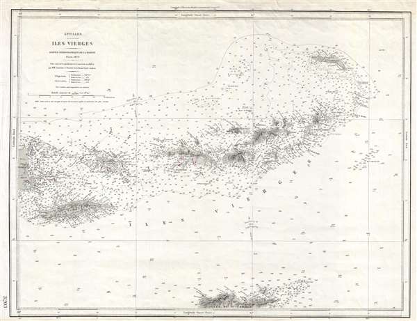
Antilles. Iles Vierges.
1960 (dated) 19 x 25 in (48.26 x 63.5 cm) 1 : 288000
1960 (dated) 19 x 25 in (48.26 x 63.5 cm) 1 : 288000
Description
An uncommon French Dépôt de la Marine nautical chart or maritime map of the Virgin Islands. The map covers the entirety of the Virgin Islands from Porto Rico to I. Anegada and extends as far south as St. Croix. This map was first issued in 1873 and is most likely based upon British Admiralty Charts. The latest update noted in 1932, but notes on the map suggest additional updates as late as 1960. Necker Island, the paradise owned by British billionaire Richard Branson, is noted. Represents Dépôt des Cartes et Plans de la Marine chart no 3203.
Cartographer
Dépôt des Cartes et Plans de la Marine (fl. 1720 - present), often called the Dépôt de Marine, was a French hydrographic mapping organization founded in 1720 under Charles-Hercule of Albert de Luynes (1674 - 1734). Much like the U.S. Coast Survey, the British Admiralty, and the Spanish Deposito Hydrografico, the Dépôt was initiated as a storehouse and distribution center of existing nautical and marine charts. Eventually the Dépôt initiated its own mapping activities in an attempt to improve and expand upon existing material. Some of the more prominent cartographers and hydrographers associated with the of Dépôt des Cartes were, Philippe Buache, Jacques-Nicholas Bellin, Giovanni Rizzi-Zannoni, Rigobert Bonne, and Jean Nicolas Buache. More by this mapmaker...
Condition
Good. Lower margin extended.